foothillscrewzone
Member
Can you compare with 00z?
Can you compare with 00z?

Thats .5 qpf. at 18-20:1 ratio, that would net you roughly 7.5-8 inches, minimumWow that’s not encouraging. Perhaps it may not be as consistent and good as we thought it was. Did a great job last storm though
Sent from my iPhone using Tapatalk
Thats .5 qpf. at 18-20:1 ratio, that would net you roughly 7.5-8 inches, minimum


Not sure but if it shows 0.50 liquid on you then shows 4-6 inches of snow that's 10:1 and everyone has said it won't be 10:1 ratiosDidn’t bouncy corn state that while it says 10:1 google actually processes using dynamic ratios
This is very bullish, maybe they are seeing more potential than we are. However, I would forecast RAH to be in the 5-8" range so its within my forecastRAH updated totals (may be automated NBM output but regardless, I think this is very bullish)
It says 10:1, but I added a slightly dynamic ratio where very cold temps get 12:1.. but we're looking at ratios of 20:1 in some areas.Didn’t bouncy corn state that while it says 10:1 google actually processes using dynamic ratios
not at all. but brad p posted it earlier so maybe it's not as bad as i think it isIs the HRRR reliable towards the end of its 48hr rum?
On this release RAH bumped Raleigh to 9" of expected snow. 11am had it at 8" of expected snowThis is very bullish, maybe they are seeing more potential than we are. However, I would forecast RAH to be in the 5-8" range so its within my forecast
High Resolution Rapid Refresh. It runs updated to current conditions every hour. It’s value is more inside 12 hourswhat even is the hrr lmao
No, that's 2 cases!Is the HRRR reliable towards the end of its 48hr rum?


It's almost like they're doing more than living and dying by the latest NAM, HRRR, or GRAF. These folks went to school for a reason. Anyone can hug a model. Some mets don't help themselves by posting individual runs (for good or ill) on social media.On this release RAH bumped Raleigh to 9' of expected snow. 11am had it at 8" of expected snow


Any chance they showed it further southeast?
It's almost like they're doing more than living and dying by the latest NAM, HRRR, or GRAF. These folks went to school for a reason. Anyone can hug a model. Some mets don't help themselves by posting individual runs (for good or ill) on social media.
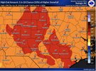
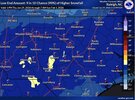
Meteorology v/s ModelologyI’ll be curious to read the RAH afternoon discussion because I’m genuinely confused what they are seeing that we aren’t. That low end map is mind boggling to me
Maps must be automated based on NBM since they only mention 2 to 6 in latest discussion from 2pm.I’ll be curious to read the RAH afternoon discussion because I’m genuinely confused what they are seeing that we aren’t. That low end map is mind boggling to me
Not sure, a family member sent that to me.Any chance they showed it further southeast?
The AFD as of 2:05 pm says 2-6".I’ll be curious to read the RAH afternoon discussion because I’m genuinely confused what they are seeing that we aren’t. That low end map is mind boggling to me

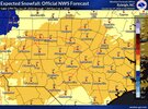
Not bad for 1pm Sat. About half-way thru the storm and before the surface LP really kicks
Somebody mentioned the "stacked low" on this thread earlier in response to my post about the potential fujiwhara effect of the developing coastal. Could have some decent yieldsThe AFD as of 2:05 pm says 2-6".
View attachment 191333
this is so far off from the 9" the NWS is forecasting for the Triangle currently. I personally think this is a more realistic bet (2-6 in.) but am surprised to see them so divergentThe AFD as of 2:05 pm says 2-6".
View attachment 191333