packfan98
Moderator
6z euro looks much better for the Georgia folks so far. Still running.


Holy smokes... that'll wake you up in the morning!!! Best run of the whole storm for the Upstate and NE Georgia!And the love continues to the SC folks next!
View attachment 191099

Dang didn’t expect to see that this morning. Wonder if we can keep that up until go time?And the love continues to the SC folks next!
View attachment 191099

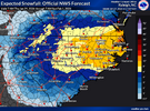
Winter Storm Warning


I just realized all these AI clown maps are 10:1..So you can add 50% to this map above. 4-6 should actually be 6-9. Thats 15;1 ratio. not out of the question for it to sniff 18:1 / max 20:16z AI solid. 2-3” for Raleigh…4-6” towards Charlotte-GSO-AVL.
View attachment 191095
Issues watches at 1am.. Waiting for the grids to update if changing to a warning.Dang they just issued a watch a few hours ago. Must be a typo because it's still a watch.
I’m sure they are leaning towards climatology. Also they may not be sold on how far south the ULL is digging?I don’t understand why nws gsp really believes the north of I40 in the piedmont sees the best chance of high totals. I think the further south you go the better chance
Sent from my iPhone using Tapatalk
I dont think ive ever seen the euro give me that much snow at this time rangeWinners and losers with this run.
View attachment 191103
My jaw dropped when I saw this run for western folks. I always imagined the ceiling for places like ATL at 2-4 inches since the Canadian and RGEM were the most aggressive... The EURO of all models has now raised the high end (4-6 inches) which is pretty wild in my opinion. Maybe it is picking up the upper level feature better than before and accounting for those higher-end totals, but man that seems so far-fetched that I would take even this run with 5 grains of salt.Winners and losers with this run.
View attachment 191103
I’m sure they are leaning towards climatology. Also they may not be sold on how far south the ULL is digging?


Yessir!
Good to see Euro throwing a bone to NE Alabama.Winners and losers with this run.
View attachment 191103
This is a "if you build it, they will come" look QPF-wise over here. Winners/losers pattern with banding still seems likely in my mind, but boy you can get some big totals from this
They might a little, but often in the past, they have waited for an event to start to begin raising totals.I expect GSP to start inching totals up across all of the western Carolinas and NE Georgia
For hr68, I would think the euro. However it is one of the more southern solutions. I think I would go blend 70% euro and 30% nam.
Historically, this storm`s setup is most like the December 24, 1989
and early March 1980 storms. Both of these historic events produced
12+" of snow for Eastern North Carolina with accumulations from
the March 1980 storm nearing 24" in some areas. While there`s
potential for this weekend`s snow accumulations to be comparable
to these past events, keep in mind that we`re still more than
48 hours out from when the heaviest snow is expected to fall,
which means there`s still room for adjustments (up or down) in
the accumulation forecast.