I don't even know what to say...this start Friday evening on the AIFS
6hr precip panels
View attachment 189699
10-14 days of lows in the teens/low 20s and our newly formed glacier may actually kill the fire ants.
I don't even know what to say...this start Friday evening on the AIFS
6hr precip panels
View attachment 189699

Western Carolina’s looks to be losing it. Great look for eastern nc and the coast though!
Sent from my iPhone using Tapatalk

Locked in already!
Please stop making this comment about something 6 days awayWestern Carolina’s looks to be losing it. Great look for eastern nc and the coast though!
Sent from my iPhone using Tapatalk
Looks awfully similar to the weather next. Just a little less to the west.Holy moly!
View attachment 189703
It’s really only 4 days away at least from the start of the event. But yeah, agreed.Please stop making this comment about something 6 days away
I remember this map about 5 days before this last stormHoly moly!
View attachment 189703


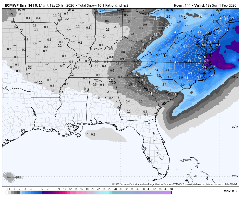
All hail King Euro! If this map were to verify this one storm would produce the equivalent of four average winter snowfalls for Raleigh.Holy moly!
View attachment 189703

Euro AI has the better wave pass. Farther south / better tilt. Since this is the Machine Learning Mauler Thread, I'm going with the AI version here
View attachment 189707

This is a crazy test for it — if it wins here and every other model folds over the next 4 days or if it’s just crazy sauce.Honestly don’t know why we’re even wasting all this bandwidth on lesser models.
SnowGod WeatherNEXT has already spoken its gospel.
Sent from my iPhone using Tapatalk

All hail King Euro! If this map were to verify this one storm would produce the equivalent of four average winter snowfalls for Raleigh.

It sure seems like everything is just coalescing around weathernext.AIFS mean went down a tad but the probabilities of 1/3” increased including back further west into WNC/SC. Interesting


Still have time for a NW trend lol.
Thankfully the Euro AI has more love for the Midlands and Upstate.
Tidal flooding and some large driftsSingle Digits while it's snowing. View attachment 189706View attachment 189705
Is snow that far southeast over open ocean possible? I assume the water temps have some effect.
What are your thoughts about S.C. in this setup?This is a great looking setup, just a classic miller a event for nc synoptically. +PNA, strong west-based -NAO, big cold high diving down the Plains, deep TN valley trough, and reasonably strong subtropical jet is usually how you’re supposed to do it.
I also really like the nice healthy snow pack we’ve got to the NW of NC now after this storm. That should help keep the baroclinic zone reasonably suppressed to benefit nc if we were to get some synoptic shifts that favor a north trend somehow. It’s hard to push a big low way to the north when it’s being met with cold and stable low level air mass reinforced by deep snow cover. Also will be very helpful with low level cold air transport
Dont forget the Canadian!Give me the jma or spire. Course i aint compalining about any of them.


The Canadian did well with the past event.


