Looking like freezing drizzle until late afternoon.Is central NC dryslotted at this point? HRRR showing only 0.03 further accumulation in Raleigh before the squall line.
-
Hello, please take a minute to check out our awesome content, contributed by the wonderful members of our community. We hope you'll add your own thoughts and opinions by making a free account!
You are using an out of date browser. It may not display this or other websites correctly.
You should upgrade or use an alternative browser.
You should upgrade or use an alternative browser.
Wintry January 23rd-27th 2026
- Thread starter SD
- Start date
Dust flying around in Chapin.
rusrius
Member
23.9 degrees here with that snowy dandruff falling
NCSnowFan777
Member
Nice Sleet accumulation with some snow mixed in here in Durham, NC!

Last edited by a moderator:
Darklordsuperstorm
Member

Ron Burgundy
Member
When you go to get ready for an ice storm but your tailgate instincts take over…

chuckhendo
Member
I’ve never seen snow this small before. It’s dancing around - very cool23.9 degrees here with that snowy dandruff falling
CNCsnwfan1210
Member
Just dropped from 28 to 27 degrees in the past hr in SW Wilson county.
Sent from my iPhone using Tapatalk
Sent from my iPhone using Tapatalk
Man what if this line coming is all sleet? I mean… that would be absolutely bonkers.
WolfpackHomer91
Member
Not sure this was seen …. It’s still sleeting here moderately. Thought it was pouring rain but opened the door an its pingers

Sent from my iPhone using Tapatalk

Sent from my iPhone using Tapatalk
Would be really nice if could stay sleet
praying for it to be up here, already mainly beenMan what if this line coming is all sleet? I mean… that would be absolutely bonkers.
Would love itMan what if this line coming is all sleet? I mean… that would be absolutely bonkers.
Iceagewhereartthou
Member
I'm noticing the core of this wedge is centered just SE of I-85 in the upstate. Still a lot of mid to lower 20s there to the midlands. NW of 85 has risen pretty significantly to upper 20s. We'll have to see what that means for the bigger batch this evening, as some of those areas may go above freezing.
Attachments

LovingGulfLows
Member
- Joined
- Jan 5, 2017
- Messages
- 1,499
- Reaction score
- 4,100
Temp here isn't rising fast enough before the line arrives. Been stuck at 30-31 now for an hour or so. Going to have to prepare for a 2nd round of ice at least at the start...this is crazy.
EDIT: Meant to say rising fast enough.
EDIT: Meant to say rising fast enough.
Same here. I asked my good friend Chad G.P. Tee about this and here’s what he sent me:
Why rain can occur in wedge areas with surface temps in the upper 20s
- Warm advection aloft with a shallow cold layer near the surface: The surface is cold (upper 20s °F), but the air above the shallow boundary layer is warmer. If the temperature profile is: surface near or just below freezing, a rapid warm layer a few hundred to a couple thousand feet thick above, and then cooler air aloft, precipitation can fall as rain through the warm layer and remain rain at the surface if the surface layer is not too cold or if the cold air is shallow enough that rain doesn’t have time to cool and freeze on contact.
- Temperature profile above the surface determines precipitation type: If the layer of subfreezing air at the surface is thin and the temperature just above the surface is above freezing, raindrops can reach the surface as rain or as drizzle. If the cold layer is shallow enough and the surface temperature is just below freezing, you may still get rain if the raindrops don’t have enough time to warm and refreeze (or if the surface warms slightly with solar input or ground warming).
- Boundary layer mixing and heating: Surface winds and mixing can bring slightly warmer air to the lowest few hundred feet, lifting the surface temperature a degree or two above freezing during precipitation. If the surface is in the upper 20s but warms to near 32°F at the very surface due to radiative cooling constraints breaking during daytime or due to frictional heating, rain can reach the ground.
- Ground temperature and melting layer: Rain can survive as rain if the cold surface layer is not deep enough to freeze the falling droplets before they reach the ground, especially if the ground itself is not cold enough to induce rapid freezing of water on contact.
- Temporal evolution: In a wedge, the temperature profile can evolve during the event. Initially there may be freezing rain or sleet, but as warm air advection persists at mid-levels, the low-level temperature can rise or the warm layer can thicken, producing rain even if surface temps stay in the upper 20s.
Tony @dsaur has posted many times about the ice buildup being so bad despite temps being right at or only just below 32 for the bulk of the severe 1/1973 icestorm. Also, for the two icestorms of 1/2000 that I saw, the temps were mainly 30-31 for the bulk of them and that was cold enough for ice to easily buildup.
I was curious. So, I just looked back at the old 850 mb maps. A key difference between those three and today’s at ATL are the 850s. For the 1/1973 storm, they were largely in the +3 to +4C range. For the two in 1/2000, they were mainly +3 to +5 for much of them with ~+7 for the max of the 1st one (late). In stark contrast, the 850s for today’s ZR have been a much warmer +9 to +11.
So, at ~4K feet above the ground, 850s were only 37-39F in the big 1/1973 icestorm and mainly 37-41F for the two icestorms in 1/2000. But today, they were way up at 48-52F!
So, despite similar 2m temps to 1973 and 2000, the ~11F warmer 850s (4K feet above the ground) made it much harder for the ZR to accrue efficiently today vs 1/1973 and 1/2000. This is in hindsight as most of us (including myself) didn't know how much was actually going to accrue as many others and I were getting concerned last night as the large area of precip on radar was moving in.
Edit: the good news is that 850s are even warmer (up to +12C to +13C/54-55F) for this afternoon’s precip. So, I’d think that anyone in the ATL area still at or just below 32 wouldn’t have much icing.
Opinions?
Last edited:
Whats timing, 3pm?Storm is far from over. That last squall is predicted to bring us over 0.25" itself here in central NC. That combined with the wind is insane
coldspringsfarm
Member
Lots of variables at play. Daytime sun angle can cause ground/roof/etc to warm above the air temp, the relatively warm rain can fall fast enough that the rate of freezing is inefficient, the act of the rain freezing releases latent heat causing freezing efficiency to suffer the closer you get to 32F.I guess i just dont understand how the temp is 28 here and the rain is falling on ice/sleet and puddling? I would assume at 28 rain falling would on top of ice would freeze but we have more like slush currently
rburrel2
Member
I don’t think this is entirely true because just northeast of Atlanta saw lots of sleet. So if rain drops cooled enough to form sleet, they were clearly supercooled and borderline forming sleet in Atlanta.Tony @dsaur has posted many times about the ice buildup being so bad despite temps being right at or only just below 32 for the bulk of the severe 1/1973 icestorm. Also, for the two icestorms of 1/2000 that I saw, the temps were mainly 30-31 for the bulk of them and that was cold enough for ice to easily buildup.
I was curious. So, I just looked back at the old 850 mb maps. A key difference between those three and today’s at ATL are the 850s. For the 1/1973 storm, they were largely in the +3 to +4C range. For the two in 1/2000, they were mainly +3 to +5 for much of them with ~+7 for the max of the 1st one (late). In stark contrast, the 850s for today’s ZR have been a much warmer +9 to +11.
So, at ~4K feet above the ground, 850s were only 37-39F in the big 1/1973 icestorm and mainly 37-41F for the two icestorms in 1/2000. But today, they were way up at 48-52F!
So, despite similar 2m temps to 1973 and 2000, the ~11F warmer 850s (4K feet above the ground) made it much harder for the ZR to accrue efficiently today vs 1/1973 and 1/2000. This is in hindsight as most of us (including myself) didn't know how much was actually going to accrue as many others and I were getting concerned last night as the large area of precip on radar was moving in.
Edit: the good news is that 850s are even warmer (up to +12C to +13C/54-55F) for this afternoon’s precip. So, I’d think that anyone in the ATL area still at or just below 32 wouldn’t have much icing.
Opinions?
If true, the rain drop temperature is the same, doesn’t matter how warm 850mb was, it could have been 100 degrees. Just so long as the rain drops had adequate time to cool to freezing, or supercooled below freezing.
Ron Burgundy
Member
SVR T storm warning in Montgomery and ZR radar returns in Macon 

Have to say the NAM seems to have done quite well with the spotty precip and showing more sleet than ZR like other models had.
Looks like 3:30-4:00We are in a lull here. When’s this big line supposed to arrive and how long will it last?
WolfpackHomer91
Member
Storm is far from over. That last squall is predicted to bring us over 0.25" itself here in central NC. That combined with the wind is insane


Bradley seems worried
Sent from my iPhone using Tapatalk
packfan98
Moderator
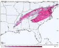
Ok. Interesting news from the hrrrr. The latest run is picking up on the squall line having sleet in it. Makes me think that the super cold regions may get all sleet. That would be pretty cool.


As he / we should be. It also looks after dark, which will help with any ice accrual (no daytime sun angle, which I would think affect accrual efficiency some, especially when you get in the 28F+ temperature range).

Bradley seems worried
Sent from my iPhone using Tapatalk
Our best hope is that it is sleet, and if it is it will be truly awesome. Light sleet is kind of lame, especially compared to snow, but heavy sleet is legitimately cool!
Last edited:
TigerSnow
Member
Hoping we can be all sleet. Might help us all outOk. Interesting news from the hrrrr. The latest run is picking up on the squall line having sleet in it. Makes me think that the super cold regions may get all sleet. That would be pretty cool.
View attachment 189073View attachment 189075
ATLHokie
Member
Y'all in the Carolinas get to watch us in N GA try it first.... may give it away... who knows.Ok. Interesting news from the hrrrr. The latest run is picking up on the squall line having sleet in it. Makes me think that the super cold regions may get all sleet. That would be pretty cool.
View attachment 189073View attachment 189075
iGRXY
Member
I’m sitting at 20. Spartanburg is 22. It’s still low 20’s along and east of Highway 25 in greenvilleI'm noticing the core of this wedge is centered just SE of I-85 in the upstate. Still a lot of mid to lower 20s there to the midlands. NW of 85 has risen pretty significantly to upper 20s. We'll have to see what that means for the bigger batch this evening, as some of those areas may go above freezing.
That's very interesting. I've been hearing the column wouldn't be cold enough for sleetOk. Interesting news from the hrrrr. The latest run is picking up on the squall line having sleet in it. Makes me think that the super cold regions may get all sleet. That would be pretty cool.
View attachment 189073View attachment 189075
packfan98
Moderator
There may be enough dynamics that it might be a hail/sleet thing? Wacky stuff!That's very interesting. I've been hearing the column wouldn't be cold enough for sleet
So this will be ZR/IP as it crosses into Upstate and NC????? That would be insane!! 
CNCsnwfan1210
Member

Measured 1/4 inch of ice accrual on the top side of the branch, hardly any ice on the bottom side. Temp down to 27 now approaching 1 pm, down from 28 in the past hour in SW Wilson county NC
Sent from my iPhone using Tapatalk
But, but the Euro said we would be in the mid-30s for it.So this will be ZR/IP as it crosses into Upstate and NC????? That would be insane!! View attachment 189083

I’m sitting around 24. I like my odds hereI’m sitting at 20. Spartanburg is 22. It’s still low 20’s along and east of Highway 25 in greenville
Mannnnn. This line of storms is literally about 25 minutes from hitting and I am stuck at 30.4.
It has to warm up and quick.
Sent from my iPhone using Tapatalk
It has to warm up and quick.
Sent from my iPhone using Tapatalk
WolfpackHomer91
Member
Ok. Interesting news from the hrrrr. The latest run is picking up on the squall line having sleet in it. Makes me think that the super cold regions may get all sleet. That would be pretty cool.
View attachment 189073View attachment 189075
Yea, getting more sleet now moderately …. I have a glaze of ICE overall that’s it, roughly 1” of SN/IP. I’d almost say if you’ve been sleet this entire time you’ll stay sleet, If not you’ll switch but Idk
Sent from my iPhone using Tapatalk
Wow 


So this will be ZR/IP as it crosses into Upstate and NC????? That would be insane!! View attachment 189083
