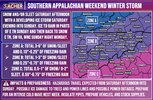
I think you made the right call, although cutting a vacation short is a call I've never had to make so I can imagine how difficult that must be! You may very well have been fine coming back on Saturday, but it's definitely a risk and it's really hard to forecast the exact starting time at this juncture!Thanks, my friend!
My wife and I would normally just take the flight we had originally scheduled and not really sweat it. Because who doesn’t mind being stranded on a tropical Caribbean island with great food. LOL
But our parents are aging—my mother lives alone after my father died—and we’re the only household within our extended family with a wholehouse generator. So we have people relying on us.
We went ahead and checked in for tomorrow’s flight. Our big concern is—even if the arrival of the winter mess is delayed in NC—there’s no guarantee that the airline won’t have to juggle equipment around due to upstream delays and cancellations elsewhere in the system. This is a big storm of course and they could cancel Saturday’s flight regardless of conditions at CLT.
-
Hello, please take a minute to check out our awesome content, contributed by the wonderful members of our community. We hope you'll add your own thoughts and opinions by making a free account!
You are using an out of date browser. It may not display this or other websites correctly.
You should upgrade or use an alternative browser.
You should upgrade or use an alternative browser.
Misc General Banter Thread
- Thread starter Rain Cold
- Start date
Every 30 minutes i check i hear something different for ATL lmaoFortunately for Atlanta I think temps will be in the low 30s instead of the 20s and that makes a difference.
When people mention Atlanta, its a 100 mile diameter swath with various elevations. I am going to take the hi-rez models with a grain of salt until they are inside of 54 or 60 hours. The globals are pretty much in alignment now that the freezing line gets close to the Alabama line down to central Georgia, and over toward Augusta. Where the CAD breaks on Sunday is unknown at this time and shouldn't be assumed. High temperatures Sunday could be anywhere from 35 to 60 south and west of town, TBD.Every 30 minutes i check i hear something different for ATL lmao
Noles1812
Member
In a power outage with single-digit nights, your primary options are to either use temporary insulation and alternative heat sources or, most effectively, to drain the water from your plumbing system.
Option 1: Temporary Measures
If you still need access to water and the outage is expected to be short, try these steps:
Option 2: Draining the System (Most Effective for Prolonged Outages)
If the power outage is prolonged and temperatures remain extremely low, the safest method is to drain the plumbing system completely to prevent bursting pipes:
Option 1: Temporary Measures
If you still need access to water and the outage is expected to be short, try these steps:
- Insulate exposed pipes: Wrap any exposed pipes in unheated areas (attics, crawl spaces, garages, under sinks) with towels, blankets, or even newspaper and plastic wrap to provide a temporary barrier against the cold.
- Open cabinets: Open kitchen and bathroom cabinet doors to allow warmer internal air (from alternative heat sources) to circulate around the pipes within the walls.
- Use alternative heat sources safely: If you have a fireplace, wood stove, or a safe, well-ventilated kerosene/propane heater, use it to warm the central living space, allowing some warmth to reach vulnerable areas. Never use open-flame devices near pipes or in enclosed areas without proper ventilation due to fire and carbon monoxide hazards.
- Let faucets trickle (if you still have running water): A slow, steady stream (about the width of a pencil, not just a drip) from the faucet farthest from the main water supply can keep water moving and help prevent ice blockages. Collect the running water in buckets for later use to save water.
Option 2: Draining the System (Most Effective for Prolonged Outages)
If the power outage is prolonged and temperatures remain extremely low, the safest method is to drain the plumbing system completely to prevent bursting pipes:
- Locate and shut off the main water valve: This stops all new water from entering the house.
- Drain the pipes: Start at the top of the house and open all faucets (hot and cold) and flush all toilets several times. This allows the water in the lines to drain out.
- Drain the water heater: If you have an electric water heater, turn off its power supply first. For a gas heater, turn off the gas supply line. Then, drain the tank through its drain valve.
- Protect drains and toilet bowls: Pour a small amount of non-toxic plumbing antifreeze into drains and toilet bowls to prevent the water remaining in the traps from freezing.
Coming from 35 years of flying experience. (Was a crew member for 15)Thanks, my friend!
My wife and I would normally just take the flight we had originally scheduled and not really sweat it. Because who doesn’t mind being stranded on a tropical Caribbean island with great food. LOL
But our parents are aging—my mother lives alone after my father died—and we’re the only household within our extended family with a wholehouse generator. So we have people relying on us.
We went ahead and checked in for tomorrow’s flight. Our big concern is—even if the arrival of the winter mess is delayed in NC—there’s no guarantee that the airline won’t have to juggle equipment around due to upstream delays and cancellations elsewhere in the system. This is a big storm of course and they could cancel Saturday’s flight regardless of conditions at CLT.
Here's some tips. Go ONLINE first. While you are online or chat, stand in line at the ticket counter. Have MULTIPLE options going at the same time.
Airlines are all about asset positioning. If a big storm (hurricane of ice) Airlines are about financial loss mitigation. So, they move the assets OUT of the storm. Meaning, they ground them, or more than likely move them. The key is to keep the grid moving outside of the storm as much as possible.
If I had a penny for each time I've heard "Well, it's not snowing in San Diego!". Right, but...the plane has been moved to a) avoid the storm and potential damage to a very expensive plane AND to keep the infastructure moving and READY when it's all over.
Final point. Example: CLT. No way does American try to keep most of their assets in CLT, because they lose all potential revenue with a locked down airport. Locked down planes etc.
So, if your flight is cancelled....it's because the entire web of all the airlines trying to protect and recover quick.
Hope that helps any newbies looking to fly.
Drizzle Snizzle
Member
I think its pretty much a guarantee that places like Carrollton and Newnan will be well above 32 at some point on Sunday.When people mention Atlanta, its a 100 mile diameter swath with various elevations. I am going to take the hi-rez models with a grain of salt until they are inside of 54 or 60 hours. The globals are pretty much in alignment now that the freezing line gets close to the Alabama line down to central Georgia, and over toward Augusta. Where the CAD breaks on Sunday is unknown at this time and shouldn't be assumed. High temperatures Sunday could be anywhere from 35 to 60 south and west of town, TBD.
Im in walton closer to athens so ill just assume ill see some type of freezing precip at this pointWhen people mention Atlanta, its a 100 mile diameter swath with various elevations. I am going to take the hi-rez models with a grain of salt until they are inside of 54 or 60 hours. The globals are pretty much in alignment now that the freezing line gets close to the Alabama line down to central Georgia, and over toward Augusta. Where the CAD breaks on Sunday is unknown at this time and shouldn't be assumed. High temperatures Sunday could be anywhere from 35 to 60 south and west of town, TBD.
NoSnowATL
Member
I have parents in Walnut Grove, they picked up a generator this morning. .5-.75 ice looks doable.Im in walton closer to athens so ill just assume ill see some type of freezing precip at this point
You are in the category of how much, not if. You are also in the category of possibly not reaching freezing Sunday before the winds shift to the NW. It will be interesting to see how this low pressure battles the CAD, and how far it gets before the full transfer to the coast. Its a great game for everyone to watch.Im in walton closer to athens so ill just assume ill see some type of freezing precip at this point
Welp, just got my notice to support shelter and warming certer ops here.
I've never wanted to see the NAM more correct, sorry to those that negatively impacts
Frosty has got the green light.
Ready, but hope I don’t need it.

Sent from my iPhone using Tapatalk
Ready, but hope I don’t need it.

Sent from my iPhone using Tapatalk
BHAMWX
Member
we needed you on Monday !I wanted to update the Alabamians. Fixed the map for us.
View attachment 187639
Yes. All of us. Til my last breath
rburrel2
Member
This slayed me. My wife was not amused though.Yes. All of us. Til my last breath
rburrel2
Member
Don’t take the baitWe buying the LR NAM?? Gives me two bouts of light snow!??View attachment 187696View attachment 187695
My brain is mush right now
Makeitsnow
Member
lol i should say so. Walton will be hit hard.Im in walton closer to athens so ill just assume ill see some type of freezing precip at this point
Bigedd09
Member
It’s the gfs but dang. That front thump of snow went way south

Sent from my iPhone using Tapatalk

Sent from my iPhone using Tapatalk
TWC says minor glaze in Atlanta and whatever model they use doesn’t take the city below 32. Kinda head scratching with all the modeling and their own building sitting right in the crosshairs.
Loganville Winter
Member
In Walton myself near the border of Gwinnett and Barrow. I think it’s possible we get some sleet to minimize the ZR if trends continue.lol i should say so. Walton will be hit hard.
trackersacker
Member
bah, those were supposed to be OUR jet streaks!This guy is the GOAT in the Chicago area! View attachment 187704
Drizzle Snizzle
Member
I don't see any Forecast Highs for Atlanta below 32 next week. The coldest I see is Monday at 32 and then warming in to the mid to upper 40s by Wednesday.Yeah, because it brings the Arctic down. Highs below freezing all week in Atlanta with lows in the single digits some nights. Ouch! Especially if power is knocked out Sunday.
GeorgiaGirl
Member
..oh gosh if the GFS has been on the ball here. It shows me struggling to get above freezing for pretty much the entirety of Sunday. If it’s too warm by a degree or two, I could end up being mainly freezing rain.  (and as is, the run is a disaster here)
In the meantime, my NWS has now bumped my projected high to 54 for Sunday. I’m scratching my head a little here. Even if the warmer ideas work out, I don’t see it getting warmer than the 40’s until maybe early Monday morning.
In the meantime, my NWS has now bumped my projected high to 54 for Sunday. I’m scratching my head a little here. Even if the warmer ideas work out, I don’t see it getting warmer than the 40’s until maybe early Monday morning.
ducketta27
Member
Not a troll, sorry if I offended anyone. Here for the science. ThanksI suspect he/she is a troll.
AJ1013
Member
I love snow but I'm glad I live in a place where freezing rain is impossible. I've experienced that crap once and it was enough for me.
SimeonNC
Member
My job scheduled me for Sunday lol
LongRanger
Member
There's so many different forecast they don't nobody have a clue what it's gonna do
WolfpackHomer91
Member
Funny story I saw last night people said it may take up to 4 runs to get True data from that Recon….. 36hrs to Kickoff that’s basically 4 model Suites, everyone go measure 100 miles North on the map ….. 4 small 25 mile bumps and that’s what you’ll get.
Edit : 0Z/12Z mean more imo
Sent from my iPhone using Tapatalk
Edit : 0Z/12Z mean more imo
Sent from my iPhone using Tapatalk
blueheronNC
Member
Got my generator today but now I need to figure out how to get my gas furnace to draw from it instead of the home circuit since I’ll be running extension cords everywhere (no backfeed inlets)
I went to Ace earlier to get batteries and some lady was buying sleds
I don't want ice but I also I kinda hope the GFS verifies just so this clown has to eat crow
This guys behavior is truly unhinged and embarrassing. I’m not exactly sure why Bam exists when our tax dollars pay for the NOAA, and advertisers pay for local broadcasting.I don't want ice but I also I kinda hope the GFS verifies just so this clown has to eat crow

