WEATHERBOYROY
Member
If that were to go a lot faster it might help bring western areas back into the mix?
nah, want it slower. need to give time for the trof to neutral tilt instead of helping push it out. that piece i circled in just one part of the picture though; there's a lot more stuff going on up there to push the trof too fastIf that were to go a lot faster it might help bring western areas back into the mix?

somehow both historic and disappointing lol. takes talent to get that comboMan the EPS/Euro is absolutely dialed in to portions of the Panhandle of FL, GA & the low country of SCView attachment 184244
No, we want it slowerIf that were to go a lot faster it might help bring western areas back into the mix?
want the lp to the north to go faster and be in south dakota instead of Canada. not a faster moving trough!...that would tilt the trough more negative and help supply northern moisture......thats one of the main features missing that we had over last weekend.nah, want it slower. need to give time for the trof to neutral tilt instead of helping push it out. that piece i circled in just one part of the picture though; there's a lot more stuff going on up there to push the trof too fast


Looks like Half of NC is in the 2-412z WeatherNext with another increase for the Carolinas on the clown map, with minor tick down in GA. 6z on top, 12z bottom
View attachment 184265
View attachment 184266
I would be intrigued to know why its doing this, bc I said before I am wary of both its 2m's and snow output. I suppose more of its members are catching onto further NW and wetter solutions, as its been ticking 850s and 2ms warmer over the last day or so of runs, but I am surprised that is resulting in a notable snow mean increase12z WeatherNext with another increase for the Carolinas on the clown map, with minor tick down in GA. 6z on top, 12z bottom
View attachment 184265
View attachment 184266
That is actually still in a reasonable spot for folks in the upstate and ATL areas getting at least some light snow should a ~25-50 mile NW shift happen. Not a bad look when compared to yesterday.12z WeatherNext with another increase for the Carolinas on the clown map, with minor tick down in GA. 6z on top, 12z bottom
View attachment 184265
View attachment 184266


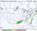
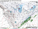
Are we cherry picking the CMC? What was the euro showing?Found some interesting images here. Radar image is from Dec 8 2017. Model is CMC. Given the setup this is not exactly entirely impossible. Snow amount wise very far fetched but seen crazier things happen before.View attachment 184267View attachment 184268
This isn't cherry picking the CMC this is looking at close analogs in comparison to some models. General trend on every model today besides a couple has been a NW trend. FGEN is most likely being underdone on models. I am not the only one that has been saying this. Models are notorious for underdoing how much slope ascent you actually need for QPF rates. Bottom line here is 00z runs are going to be important as we get more recon sampling today. Side note, CMC was actually the first model late in the trends to show amped up and everyone threw it away because of it.Are we cherry picking the CMC? What was the euro showing?
I definitely find it interesting that the CMC, known to have a cold and snowy bias (last year is a good example) that trends back to reality right as we reach short range territory is doing the opposite where it started off cold and dry, then added the moisture, and is now showing the overlap of cold air and moisture instead of doing it the other way around like usual.Found some interesting images here. Radar image is from Dec 8 2017. Model is CMC. Given the setup this is not exactly entirely impossible. Snow amount wise very far fetched but seen crazier things happen before. If you look at the rain/snow line. It lines right up where the moisture line is on CMC. FGEN could possibly be underdone even on CMC. More than likely wherever this band sets up there is going to be a decently large snow band on the NW side. Hince the NW ticks.View attachment 184267View attachment 184268
NW trend is likely to continue depending on what data we get tonight from sampling by recon. Hope for the bestI definitely find it interesting that the CMC, known to have a cold and snowy bias (last year is a good example) that trends back to reality right as we reach short range territory is doing the opposite where it started off cold and dry, then added the moisture, and is now showing the overlap of cold air and moisture instead of doing it the other way around like usual.
The Euro was not suppressed at all.Are we cherry picking the CMC? What was the euro showing?
This isn't cherry picking the CMC this is looking at close analogs in comparison to some models. General trend on every model today besides a couple has been a NW trend. FGEN is most likely being underdone on models. I am not the only one that has been saying this. Models are notorious for underdoing how much slope ascent you actually need for QPF rates. Bottom line here is 00z runs are going to be important as we get more recon sampling today. Side note, CMC was actually the first model late in the trends to show amped up and everyone threw it away because of it.
Im in the half to 1 inch area so a 25 mile shift would mean a lot one way or the other. Dancing on a razors edge here and the rest of north central gaThat is actually still in a reasonable spot for folks in the upstate and ATL areas getting at least some light snow should a ~25-50 mile NW shift happen. Not a bad look when compared to yesterday.
GDOT has some snow plows well north of this line btw as a precaution.

so far all rainlong range HRRR doesn't get it done for anyone


trends with hrr should continue to just be completely random until we get inside 24 expect anything