packfan98
Moderator

Unless its rate driven, that's a cold rain look.


Imo it's likely a cold rain unless this thing gets into GA, AL and MS where the best temps are. Maybe the far edge gets snow in a less amped scenerio? But CF stalling over the mountains isnt good for the carolinas. Normally overrunners only succeed with CAD and there just isnt one in this scenerio.Unless its rate driven, that's a cold rain look.
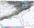
AUG/CAE/CLT/RDU folks with a bone here. Is that a meso-low over Pickens county in SC?

it showed up early in the run, probably noise; but would throw a fly in the ointmentAUG/CAE/CLT/RDU folks with a bone here. Is that a meso-low over Pickens county in SC?
It would have to happen, and happen 100+ miles to the west, to see any meaningful impact....but definitely something to hold on to if you're willing to suffer another 24 hours.Forget the surface depiction for a moment. See that little 'tail' trying to tuck under at the base of our trough? Just a smidge more of this, and Happy Hour would be jumping. The obituary might want to hold off for a bit longer for some.
View attachment 184288
I might as well. We've been glued to every run for what, a week now? lol.It would have to happen, and happen 100+ miles to the west, to see any meaningful impact....but definitely something to hold on to if you're willing to suffer another 24 hours.
The ai models all showed the same strip of accums similar to this nam run up from cola towards RDU, something agreement possibly?
Yes, it wouldn't take much for you to see something nice.I might as well. We've been glued to every run for what, a week now? lol.
Here on the east side of Atlanta, unlike this latitude in Alabama, a minor shift is all I need.
Just confirming- this circled area is what you're referring to when you say "tail", right? We're about out of straws to grasp.Forget the surface depiction for a moment. See that little 'tail' trying to tuck under at the base of our trough? Just a smidge more of this, and Happy Hour would be jumping. The obituary might want to hold off for a bit longer for some.


i do think the verifying snow map will look something like this- a child's blanket that they've been dragging around since they were 23k NAM isn't as pretty towards the south on accums:
View attachment 184290
But if the 12k worked as depicted, I believe it actually works, while it's not IMBY, I did get a sounding that is 34/33 nearby with heavier looking precip and while I'm not the greatest at determining sounding, that would be rate driven snow.
I can certainly buy some wet snow occurring back over the Triad/Greensboro atea and along/NW of I-85 in central NC.
Low-level thermals are very questionable from the Triangle area and points east + south, even on the NAM
Yes. It's a meso feature that the NAM cooked and is the type of small feature that can show up at the last minute in a situation as close as this.Just confirming- this is circled area is what you're referring to when you say "tail", right? We're about out of straws to grasp.View attachment 184291
I figured as much- and agree-if that can wind up a smidge or 2, it would be a game changer.Yes. It's a meso feature that the NAM cooked and is the type of small feature that can show up at the last minute in a situation as close as this.
I can certainly buy some wet snow occurring back over the Triad/Greensboro area and along/NW of I-85 in central NC.
Low-level thermals are very questionable from the Triangle area and points east + south, even on the NAM


That’s in theory a fairly long duration event for C NC. In theory.
Do you still personally think northeast georgia is in a good spot?
Idk man, we can hope. I said it before, weird that the NAM suite has the colder thermals, usually it's the other way around. If it was sniffing the warm nose, we'd know it would be right but snow, forget it
Yeah, I think models are underdoing QPF rates and possibly even the vorts tilt, just don't really have a way to know for sure until closer to the event.If you can get the precip there, it’s cold enough. Would be a shame if we wasted this setup in places like Atlanta
Genuine question as someone who is trying to make sense of these models: is there a time frame where these short-range models are weighed more heavily in a forecast than the globals?
If you can get the precip there, it’s cold enough. Would be a shame if we wasted this setup in places like Atlanta
Come on over and help us reel in a few flakesSeems like my trip to Augusta ga this weekend will be the right place
Aiken is actually exactly where I’m going. Am concerned about temps, but we will seeCome on over and help us reel in a few flakes
Feel like we are going to sure waste it over here from Birmingham south and what a bummer. We will pray for some magically neutral to negative tilt or a very poor forecasted precip shield. That SREF was a nice footprint but we need NW trends from now until verification. Sure hope some of our southern counties can score if we can’t.