Unfortunately a radiational cooling night is a good bit more likely to undercut model temps vs what we will be seeing on sunday morning IMOThe models were largely too warm for this morning’s lows:
Actual lows
NC:
Charlotte 19
Asheville 15
RDU ~20
GSO ~15
FAY 18
SC:
GSP 16
CAE 17
GA:
AHN 17
MCN 17
SAV 22
6Z Models: NAM, GFS, Euro had 20s at all of these and thus were mainly 5-10 too warm though Asheville was close
6Z NAM lows:
View attachment 184192
6Z Euro lows:
View attachment 184193
Icon was slightly colder and thus was close on some though even it was a few degrees too warm at others of these.
Implications, if any, for the 2m progs for the upcoming threat?
-
Hello, please take a minute to check out our awesome content, contributed by the wonderful members of our community. We hope you'll add your own thoughts and opinions by making a free account!
You are using an out of date browser. It may not display this or other websites correctly.
You should upgrade or use an alternative browser.
You should upgrade or use an alternative browser.
Jan. 17-18, 2026 SE Winter Weather Threat
- Thread starter RBR71
- Start date
FWIW could get some changes from the American models tonight with TEAL71 & 72 flying obs missions. I think it would be ingested for the 00z suite.
Tsappfrog20
Member
I will say Raleigh is at least preparing they have brined the major interstates. I know 540 and 440 have been brined!
Sent from my iPhone using Tapatalk
Sent from my iPhone using Tapatalk
Dunkman
Member
There was brine on some secondary roads near the airport on my drive to work in Greensboro this morning.
I will say Raleigh is at least preparing they have brined the major interstates. I know 540 and 440 have been brined!
Sent from my iPhone using Tapatalk
First positive trend of the day: We need to keep the base of the longwave trough ticking west right up through verification at this time-stamp to stand a chance.
packfan98
Moderator
EastmanGAWX
Member
For those who dispute snow being rare in the lower half of Georgia, I’ll give you this case example. I’m 38 years old and have lived in Eastman, GA the vast majority of my life (outside of college and some work experience) and accumulating snowfalls have happened exactly six times. The dates are 12/23/1993, 1/03/2002, 2/12/2010, 1/29/2014, 1/17/2018, and 1/21/2025. Of these storms, only four produced at least one inch. If I get any type of snow, this will be the first time in my life experiencing winters with consecutive snow falls.
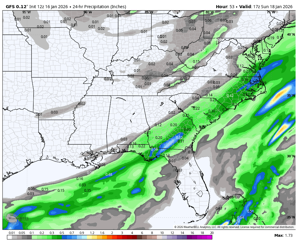
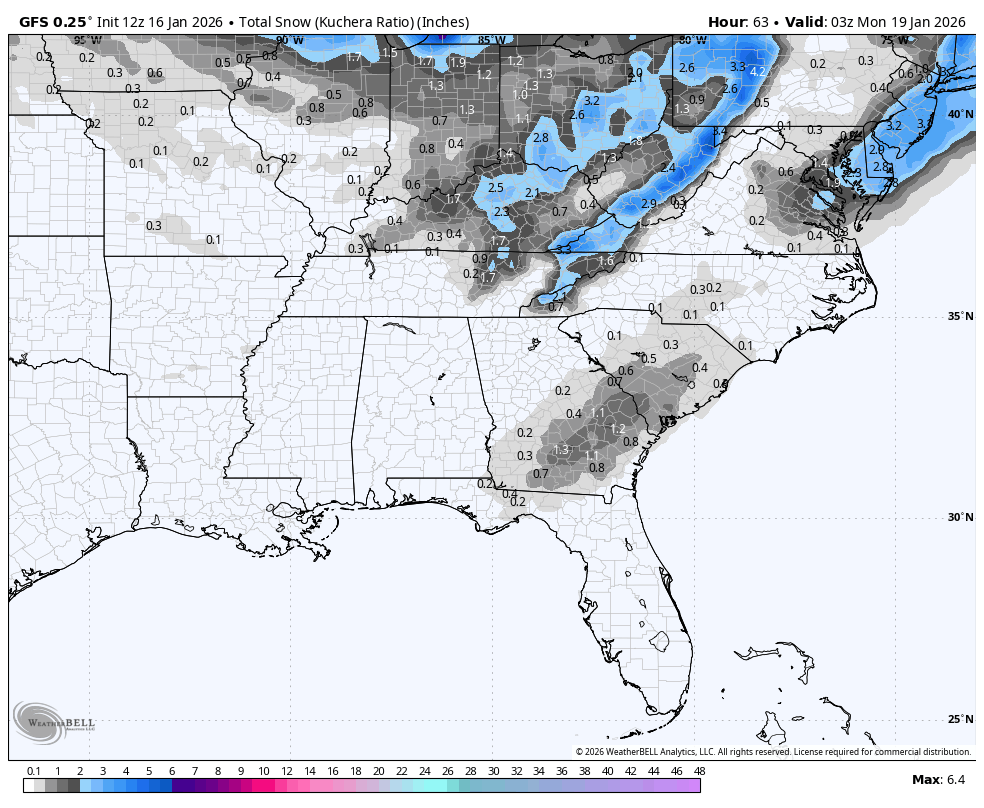
Snow to the coast on the GFS.

packfan98
Moderator
Almost seems like the timing of the start of the event is unchanged but the system is starting to become prolonged on some guidance. 


HailCore
Member
Where there are highs, lows are not far off. When there are lows, highs are not far off. I think its safe to say we had a fair share of lows overnight and this morning, so here's to starting some positive trends as we go into the afternoon, evening, and potentially into Saturday.
Baby steps, yes. Hopium, yes. But I'll grab onto any guidance that slows this down a tad.

NBAcentel
Member
Another thing that’s kinda wrecking the setup is this piece of northern stream, it’s pushing the frontal part of the vort more ahead, reducing spacing for positive vorticity advection. If that energy could shear some or head further NE embedded in the vort, better 

12z GFS is a bit of an improvement vs 06z IMO, though it’s obviously a shell of its former runs. Splitting hairs though.
This has evolved into a late blooming coastal that will hit the NE...really too bad...if it could have bloomed a little quicker and slowed down a smidge. Lot of "ifs" needed though...

Baby steps, yes. Hopium, yes. But I'll grab onto any guidance that slows this down a tad.
View attachment 184200
Huge movement of that Vort over Canada.
Something to cling to until the Doctor is in the house:

The Canadian model suite has really looked better for us over the last few runs. Of course, they showed zilch before so a dusting or non-accumulating snow is a marked improvement.Something to cling to until the Doctor is in the house:
View attachment 184206
Makeitsnow
Member
Canadian likes georgia this morning. Again a good but more of this is snow than shown. But its an outlier.


Good catch. I was myopically focused on the base of the trough. Seems like a rather large movement for an AI model, regardless of its relatively low-scale versus other AI.Huge movement of that Vort over Canada.
CNCsnwfan1210
Member
Def starting to get the look of a coastal snow for the mid Atlantic and NE
Sent from my iPhone using Tapatalk
I'm trying to dust off the ole brain from 2017 but I think I recall RGEM being one of the first ones to denote the axis of snow shift maybe I'm miss remembering or hopiumCanadian likes georgia this morning. Again a good but more of this is snow than shown. But its an outlier.
View attachment 184207
HailCore
Member
15Z Rap not any better than 09Z unfortunately. Further east overall and does not spit out snow for anybody along the SE coast

Mahomeless
Member
- Joined
- Oct 17, 2023
- Messages
- 900
- Reaction score
- 2,158
It won’t matter if the trough stays that positively tilted.First positive trend of the day: We need to keep the base of the longwave trough ticking west right up through verification at this time-stamp to stand a chance.View attachment 184195
tbh it’s a tick or two away from that boundary lighting up blue. Need this thing to really blossom and throw moisture back into the cold dome. Not skirt SW to NE around it. A lil blocking would have went a long way
Got to try to extend and give more time for that to happen so that does help but your right additional dynamics need to occurIt won’t matter if the trough stays that positively tilted.
I disagree. Every tick west allows more time for overrunning to get going as CAA is occurring and, more time for the vort to tilt more neutral. Of course, I'm referring to Georgia.It won’t matter if the trough stays that positively tilted.
New GRAF:
carolinaman
Member
Harnett County already brined all the major roads yesterday afternoon. 95, 401, 421, 55, 210, etc. If it's an all rain event at least it'll wash it off the roadsI will say Raleigh is at least preparing they have brined the major interstates. I know 540 and 440 have been brined!
Sent from my iPhone using Tapatalk

Tsappfrog20
Member
Allan’s First Map is out

Sent from my iPhone using Tapatalk

Sent from my iPhone using Tapatalk
UKMET is a little further east, and other than some trivial snow in South Georgia, a nothingburger. Portends badly for Dr. No's entrance.
LongRanger
Member
It's not gonna move NW as long as it's positive Tilted. Just not gonna happenI disagree. Every tick west allows more time for overrunning to get going as CAA is occurring and, more time for the vort to tilt more neutral. Of course, I'm referring to Georgia.
12z GEFS was a pretty nice jump NW. Grasping for straws here but it was noticeable. Someone with the weather bell graphics can post. Surprised it had not been posted yet.