SimeonNC
Member
Looking at some of the soundings for the CLT area, sleet might end up being a factor, which would be cool in a setup like this since mixed precip isn't a huge thing with Miller A's

I’m honestly worried just about precip, which, in my area has been drastically less than model forecasted for months!Looking at some of the soundings for the CLT area, sleet might end up being a factor, which would be cool in a setup like this since mixed precip isn't a huge thing with Miller A's
20/59 corridor in AL is going to get absolutely smoked if this continues. Precip continues to rise and shift NW (and its still way underdone), the neutral tilt continues to inch west with each run, and shorter range guidance is all on board.....saddle up!

Normally it plays catch up on moisture feed in these situations. I would watch for an increased moisture fetch on all levels in the next few runs and then see how that plays out at the surface.But doesn’t the NAM overdo things sometimes?
Sent from my iPhone using Tapatalk
I don't think precip is the worry here.I’m honestly worried just about precip, which, in my area has been drastically less than model forecasted for months!


I'm driving back to Montgomery from Gulf Shores that morning, so I'm probably in for a messy trip.20/59 corridor in AL is going to get absolutely smoked if this continues. Precip continues to rise and shift NW (and its still way underdone), the neutral tilt continues to inch west with each run, and shorter range guidance is all on board.....saddle up!
View attachment 183732
And it appears that the ICON really loves warm sfc temps and just completely kills snow in GA lol

The ICON looks exactly like the name at H5 through 51
Interesting they ain't buying the Euro solution.Welp. I guess the NWS already liking the amped scenario cause they have totals up through Sunday.. Swell.
View attachment 183733View attachment 183734
I disagree. A complete miss to the east is still quite likely and the worst case scenarioHere's my thoughts on the storm for the CLT area for anyone who cares.
Worst Case Scenario(as of right now): Mostly rain with a brief changeover at the end from NW to SE.
Best Case Scenario: 1-3" inches of snow across the metro, obviously less in SE areas and more in NW areas.
Interesting they ain't buying the Euro solution.

Since I already made a gif for it, I thought I would drop it here too. I saw some of y'all drawing some similarities to Dec 2017 so here is the radar loop for that event for comparison:


It's trending towards that in my opinion. That's kinda what the AIFS has been showing consistently.The worst case for everyone is the system isn't amped up & the temperature issue remains. Someone has to score.

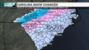
 Not sure of anyone posted this one
That's very true. A good point. The AI guidance has shown that since the beginning.It's trending towards that in my opinion. That's kinda what the AIFS has been showing consistently.
 Not bad
View attachment 183745Not sure of anyone posted this one
Not for meThe latest one backed way off on the idea of an amped solution (and honestly now looks like cold chasing moisture to me).
Agree... unfortunately... It's really difficult to imagine a mix between the Euro/GFS solutions... If you were to imagine it though, it'd look similar to the latest ICON or the AI models (with widespread temperature issues).The worst case for everyone is the system isn't amped up & the temperature issue remains. Someone has to score.
You don't wanna see the latest runNot for me