• Hello, please take a minute to check out our awesome content, contributed by the wonderful members of our community. We hope you'll add your own thoughts and opinions by making a free account!

Pattern January Joke

I try and stay out of the fray when the model runs are coming in and let the PBP guys do work. I'm happy that we are seeing proof of life with the pattern over the next 10 days. As @Ross said, it's a sticky wicket. It can work, but it might be hard. The best thing (and this IS a good thing) is that we are solidly in the game, and there are paths to victory. The ONLY thing we can do is wait. But at least it is finally good to have something to track besides a D10+ day pattern. The time for sleep is over.
In all honesty, Historical footprint would say 2,5 are most realistic should a big dog play out jmo
 
I haven't had much time to keep up with things today but looking at the latest posts, I like where we are at for January 15-16 and a potential MLK day storm. We have the moisture feed we need to fuel wintry precipitation in play and maybe, just maybe, enough cold air in place to produce some winter precipitation fun and games for many of us. I know there is going to be a lot of excitement and some sleepless nights during the next few days provided we don't get the rug pulled from under us. The signals are there according to the models and with a tweak here and there, we might be in business. Let's drop that 540 line further south and increase the QPF for all of us.
 
Slight risk of hazardous cold all the way to the coast View attachment 182050
Risk of heavy snow showing up View attachment 182052
Exciting to see these maps as of my memory is correct, the two times this map included the SE US last year days in advance ended up turning into the Jan 10 and 21 storms. It’s possible I’m forgetting another timeframe that did not work out, but I distinctly remember these maps calling for it a ways away.
 

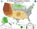
This 6-10 day, which has a notable BN temps signal, includes the 4 day period of 1/15-18, the main threat period for the 2 possible SE winter storms. Here’s the precip outlook showing mainly NN in the SE, which is wetter than the period since Dec 18th many areas (although wet is forecasted prior to this):

IMG_6882.gif

NN precip in mid Jan is more than sufficient when combined with midwinter BN temps to produce significant wintry precip. NN precip for what this 6-10 covers in the interior SE is ~0.65” on avg. If 0.65” were to fall as mainly wintry precip during this period, that could be quite impactful while also making a lot of wintry precip lovers quite happy.
 
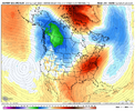
yall gotta stop worrying about clown maps and qpf charts when something like this shows up:

View attachment 182045
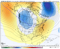
Verbatim, looks like many of us need it to go neutral earlier and dig just a bit more. First time in forever we've seen that kind of look though; hopefully somebody can cash in over the next couple weeks.
 
1767992596021.png1767992553203.png
Definitely seems like we will have some sort of warm up after the two threats. However I wonder if the mean trough trends itself more to the east as we get closer in time. That has been the trend this winter so far. Would love your thoughts @Webberweather53 or @griteater for the 25th of Jan thru the 5th of Feb.
 
The main wintry threat period for the SE is 1/15-18 as of now. How are the indices looking?

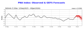
moderate +PNA: favorable and is the single most important index
IMG_6867.png

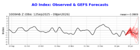
AO: starts neutral and drops to mod. -AO; not as important to have like +PNA but probably helping
IMG_6868.png

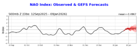
NAO: neutral to weak +NAO, which is a neutral factor as -NAO not that important per ATL/GSO/RDU winter storm NAO history that I’ve posted about
IMG_6869.png

EPO: starts off neutral and then drops to solid -EPO: favorable for 2nd storm

WPO: negative, which can’t hurt

MJO: all models have phase 6; I’ll try to post more about the implications soon in a separate post
 
The main wintry threat period for the SE is 1/15-18 as of now. How are the indices looking?

moderate +PNA: favorable and is the single most important index
View attachment 182059

AO: starts neutral and drops to mod. -AO; not as important to have like +PNA but probably helping
View attachment 182060

NAO: neutral to weak +NAO, which is a neutral factor as -NAO not that important per ATL/GSO/RDU winter storm NAO history that I’ve posted about
View attachment 182061

EPO: starts off neutral and then drops to solid -EPO: favorable for 2nd storm

WPO: negative
, which can’t hurt

MJO: all models have phase 6; I’ll try to post more about the implications soon in a separate post
The MJO phase 6 is a weak one during this period which, while not ideal, is not the end of world for our wintry precipitation chances.
 
All models are forecasting Jan 15-18th, the period for which there are now 2 SE winter storm threats, to be in phase 6. During La Niña, there have been 24 periods of phase 6 in Jan. How were temps and how much wintry precip fell at GSP?

1975 13-15th: MB/T
1976 9-22nd: MB/T
1985 1-2nd: MA/0
1989 29-31st: MA/0
1999 30-31st: NN/0.7”
2000 18-20th: BN/T
2006 24-29th: AN/0
2008 5-7th: MA/0
2009: 1-2nd: BN/0
2009 6th: MA/0
2009 9-11th: NN/0
2011 1-2nd: MA/0
2011 7-17th: MB/6.5”
2012 1-7: NN/0
2012 11-17: NN/0
2012 27-31: AN/0
2017 7th: MB/1.9”
2017 12th: MA/0
2018 29-31st: NN/0
2021 22-24th: AN/0
2021 27-31st: NN/T
2022 18-21st: BN/T
2022 29th: MB/0
2025 3-4th: BN/0

I’ll hone in on the wintry precip during the 9 B to MB temps periods (bolded) since that’s what’s expected Jan 15-18th:

Wintry precip: T, T (longest), T, 0, 6.5” (2nd longest), 1.9”, T, 0, 0

So, during the cold La Niña Jan phase 6 periods, GSP got wintry precip 6 times out of 9 (67%). Although most (4) were traces, two had sig. to major snow.

@weather bubba
 
Last edited:
first storm: i doubt there's enough time for it to curl negative in time to threaten the board. but the shortwave is sharp and robust enough to trend towards some frizzard/nodes of precip under the best dynamics, wherever that unfolds. who knows- maybe we do squeeze a coastal out of it- but if were to transpire then I'd want to see some ensemble buzz towards that solution by now. can't afford any shifts east with the wave train

second storm: better chances. slightly weirder . it looks like a fropa on modeling, which is typically not how we score. the euro showed it going negative tilt too soon which put us on the warm side. valid concern. ensembles were promising
 
Back
Top