accu35
Member

So it’s better actually. Sorry guys for my negative nonsense
i don't think that storm 1 being meh is a death knell for storm 2 but it will make staving off warmer temps on storm 2 more difficultSo basically if we don’t snow with first system then second doesn’t work?
It is 42 on this frame in CLTView attachment 182073
So it’s better actually. Sorry guys for my negative nonsense

Thank you!! It also looks to be a trailing artic behind that could make things interestingi don't think that storm 1 being meh is a death knell for storm 2 but it will make staving off warmer temps on storm 2 more difficult
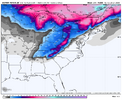
The southern front edge of that is snow via evaporative cooling, warm nose in the middle and ridging happening in the Carolina’s will most likely prevent onset snow, the Arctic front behind will have to get the job done by changing it from rain over to snow.

Agreed just posted this on another board.Ole Mid South special. Went to a CMC look from earlier.
Crashed the column at the end!The southern front edge of that is snow via evaporative cooling, warm nose in the middle and ridging happening in the Carolina’s will most likely prevent onset snow, the Arctic front behind will have to get the job done by changing it from rain over to snow.
3 degrees in Nashville at hr 231 lolCrashed the column at the end!


What happened? Did this thing ignite off the coast or something?Wait a minute!
View attachment 182075
Yes. The fate of the trailing system rests with the orientation of the upper air trough more than on how much cold air is left behind by the first system.Ole Mid South special. Went to a CMC look from earlier.
Not for us in the Upstate and Central Midlands of SC. But again, model run changes will occurs. It's close enough for a short road trip. Signal is strong! That's the positive take away for my area. Looks like NC is solid with this threat.Last minute save!
View attachment 182079
Thats unlikely
Wait a minute!
View attachment 182075
I don’t know how many times over the last few winters we lost #2 because #1 was a flop. For instance, you get a system cut too much to the north and you miss out and because it cut your second system goes too far to the south. Or just whatever. It’s infuriating.Without the first wave going bonkers its going to be harder to lock in cold for wave 2. That is just how it goes, need first wave to do crazy things!
We must believe!Yeah my bad it turned out great for the Carolinas. I guess my comment was a little Atlanta biased haha needed it tug and go neutral tilt a bit quicker! Great run though


Imagine if the base of the H5 trof was in pensacola-Tallahassee area, instead of Yazoo City Mississippi in this frame. Wed get NE GOA bomb set off with a pivot off GA coast.18z euro probably isn’t gonna cut it. We need that embedded piece of northern stream to dig further southwest and try to drop it more towards the base of the H5 trof. As long as that feature stays north, it’s a cold frontal passage with a bloomer off the coast. If that digs more, it generates precipitation while cold air advection is occuring through upper level processes, and it would be a colder setup VS just relying on the digging pacific oriented energy. Dream scenario here is digging it further southwest and cutting it off, similar to the 12z GFS. View attachment 182080


First storm right?Looking at the 18Z AIFS, the AIFS is definitely on the eastern side of its ens envelope. To me it looks like the ens is slowly heading the right direction. Also even with a poor 18z euro run, the EPS didn’t look much changed to meView attachment 182087View attachment 182085View attachment 182086


It's going to take something truly special to get upstate SC into a major snowstorm. I see Atlanta, Columbia, and even Charleston getting hit big before we do.Not for us in the Upstate and Central Midlands of SC. But again, model run changes will occurs. It's close enough for a short road trip. Signal is strong! That's the positive take away for my area. Looks like NC is solid with this threat.