Yep, especially with the HP placement. Even if it's transient (sliding)That’s a classic look for a major winter storm.
-
Hello, please take a minute to check out our awesome content, contributed by the wonderful members of our community. We hope you'll add your own thoughts and opinions by making a free account!
You are using an out of date browser. It may not display this or other websites correctly.
You should upgrade or use an alternative browser.
You should upgrade or use an alternative browser.
Pattern January Joke
- Thread starter SD
- Start date
Mahomeless
Member
- Joined
- Oct 17, 2023
- Messages
- 900
- Reaction score
- 2,158
CMC is way more plausible with storms 1 and 2 than the GFS is with them. Storm 1 500mb vort is virtually incapable of happening the way it is depicted on the GFS.
jetstream30
Member
We need a good report from the Dr. this afternoon.
Of course, the GFS is way better for east Apps folks. But I would take the canadian output in a heartbeat. Would end up being a major sleet storm for many from Atlanta to Norfork. Then we'd be overtaken by a very cold airmass. Winter at its finest. The one thing for certain, we've got things to track the next few days.
99/100 That cold angle won’t do it to the east. That cold air is going to have to settle in prior. That’s why a good whiff on storm #1 that winds up offshore, bombs to the NE and pulls high pressure in behind it may be a big help when #2 starts crawling our way
NBAcentel
Member
GEFS isn’t great at all
WolfpackHomer91
Member
This will be splendid when Panthers up 21-20 on Packers in a Blitzing Winter storm next Sunday
Sent from my iPhone using Tapatalk
LukeBarrette
im north of 90% of people on here so yeah
Meteorology Student
Member
2024 Supporter
2017-2023 Supporter

That’s a February 1989 look
rburrel2
Member
With a ridge spike like that and a fresh dry cold shot laid out in behind the first vort drop… gonna be tough to screw up the 2nd storm I think.

Iceagewhereartthou
Member
Meh, nothing but late bloomers, dry slots, and warm bubbles. If you're West of the Apps; North of I-40, above 2000 ft, East of I-77 then pay attention. If you're not....

Stormlover
Member

MichaelJ
Member
Way too early to be cashing in chips but I think if you split the difference between the Canadian and the GFS as far as track,, it could be the final solution but I am not taking bets on it
rburrel2
Member
Um, ok. Cooking with grease here. Pretty rare to see an 850 mean that cold at that range with precip in the mix. (Also had a wave of precip before this one with below freezing 850s)

WolfpackHomer91
Member
FWIW …. Ik every storm is different, but in Feb 2014 didn’t that scenario break off the first piece and on Monday it snowed like Southern NC and Upper SC to the coast then gave more of its energy to the 2nd and the big one came Weds Night into Thursday? I only mention it bc of the systems being 3 days apart as currently depicted. Of course idk the 500 charts ect
Sent from my iPhone using Tapatalk
Sent from my iPhone using Tapatalk
12 GEFS 24 hours ago through 192 had only 2 of 30 members with 0.5”+ SN somewhere in E Carolinas: members 7 and 17 and moreover, neither reached 2” anywhere:

12z GEFS today through 168 is notably more bullish with three times as many members (6) with 0.5”+ SN somewhere in E Carolinas (members 4, 18, 21, 27, 29, 30) and with half of those 6 reaching 4”+ for the max:

12z GEFS today through 168 is notably more bullish with three times as many members (6) with 0.5”+ SN somewhere in E Carolinas (members 4, 18, 21, 27, 29, 30) and with half of those 6 reaching 4”+ for the max:
CJ likes what he saw at 12z. This one might be DOA 
packfan98
Moderator
Looks like the 12 suite of ensembles for the GFS and GFS AI went colder and drier for both systems compared to 6z. We've seen the cold press ease with past systems and give the lows more room to blossom. Still time.
It was just yesterday that the main concern was boundary layer temps. (still is IMBY) I like the colder trend, and we'll work on either a well-titled vort and/or overrunning later.Looks like the 12 suite of ensembles for the GFS and GFS AI went colder and drier for both systems compared to 6z. We've seen the cold press ease with past systems and give the lows more room to blossom. Still time.
CltNative90
Member
Charlotte actually saw accumulating snow 3 days in a row with that one, 4 days if you count the trace on 2/10. First system was Tuesday morning and afternoon and mainly hit S of 85. The main system arrived Wednesday late morning and continued overnight transitioning to sleet and freezing drizzle, with the ULL pivoting through Thursday morning topping everything off with a surprise extra few inches of snow.FWIW …. Ik every storm is different, but in Feb 2014 didn’t that scenario break off the first piece and on Monday it snowed like Southern NC and Upper SC to the coast then gave more of its energy to the 2nd and the big one came Weds Night into Thursday? I only mention it bc of the systems being 3 days apart as currently depicted. Of course idk the 500 charts ect
Sent from my iPhone using Tapatalk
- Joined
- Jan 23, 2021
- Messages
- 4,604
- Reaction score
- 15,203
- Location
- Lebanon Township, Durham County NC
Remember that vividly on day one of the storm. It snowed all day and struggled to accumulate but it did break through eventuallyCharlotte actually saw accumulating snow 3 days in a row with that one, 4 days if you count the trace on 2/10. First system was Tuesday morning and afternoon and mainly hit S of 85. The main system arrived Wednesday late morning and continued overnight transitioning to sleet and freezing drizzle, with the ULL pivoting through Thursday morning topping everything off with a surprise extra few inches of snow.
Dr. No's cousin is a dud for all outside of the mountain upslope folks out to ten days.

Euro might give it a go East of the apps on the first system

NCWeatherNow
Member
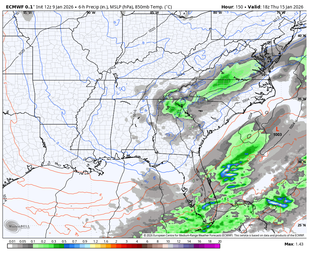
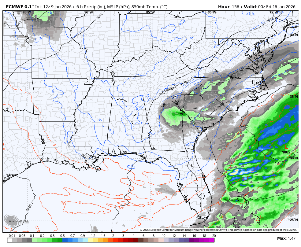
Hes a weenieCJ likes what he saw at 12z. This one might be DOA View attachment 182016

LongRanger
Member
I love how he now mentions the meteorology policeCJ likes what he saw at 12z. This one might be DOA View attachment 182016
 He's been Hammered so much lately he can't stand it. CJ is a
First one digs good, second one is coming in behind it. Gonna be an interesting run.


LukeBarrette
im north of 90% of people on here so yeah
Meteorology Student
Member
2024 Supporter
2017-2023 Supporter
Surface maps are not loading yet but both solid looks at this rangeFirst one digs good, second one is coming in behind it. Gonna be an interesting run.
View attachment 182020View attachment 182021
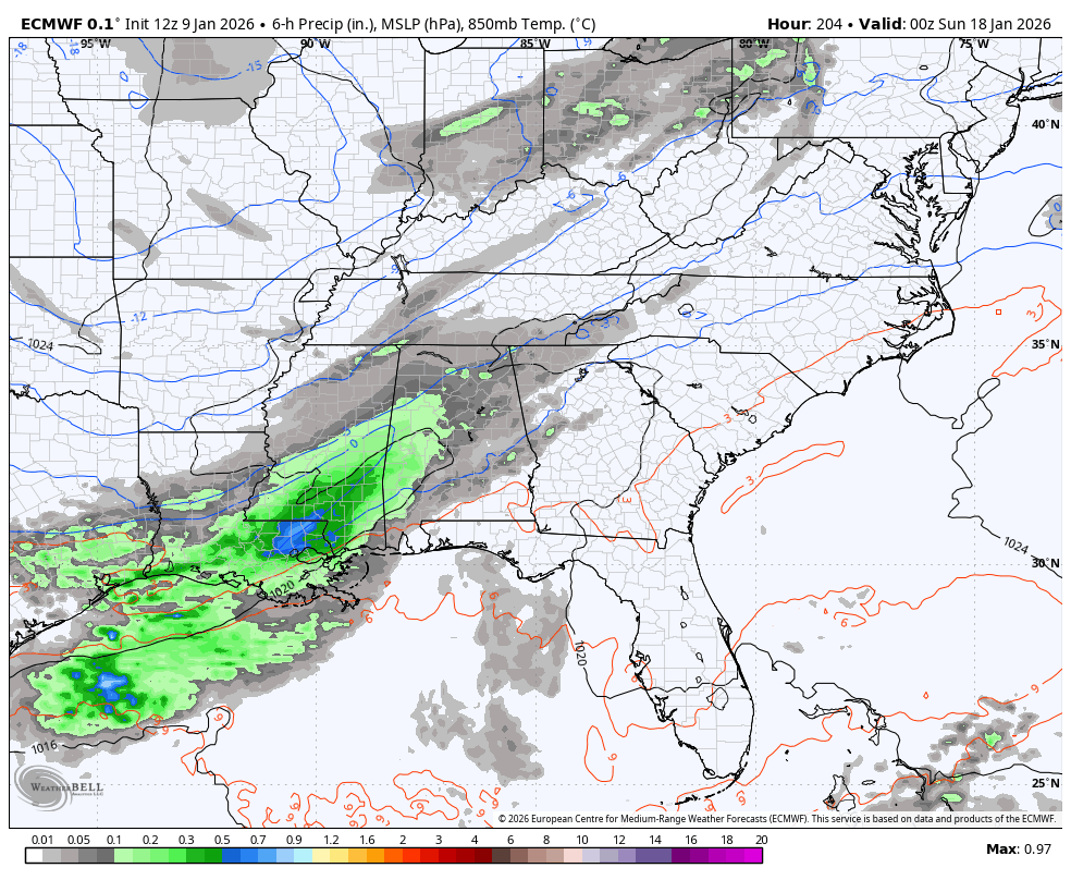
Euro popping off something significant 9-10 days out.
.png")
NBAcentel
Member
Looks like the euro snows 


LukeBarrette
im north of 90% of people on here so yeah
Meteorology Student
Member
2024 Supporter
2017-2023 Supporter

Probably mor of an interior look for Euro on second storm but wow it really amplifies
wow
Member
Looking at the 500 maps, that's a winner right there. Storm 1 looks like Jan 2000 and storm 2 looks like Jan 1996
packfan98
Moderator
Looks like about .25" of precip with the first system and .4" with the second for my backyard. Let's get these surface maps to load...
accu35
Member
I guess I’m gonna have to prescribe to weatherBell. Those maps are fast
packfan98
Moderator
packfan98
Moderator
Cold looking run. Maybe some good ratios?
broken025
Member
So we have AI vs non-AI
Dang those are some deep 850’s
jetstream30
Member
Are all three major models now showing some version of a storm with the second wave?
packfan98
Moderator
Round 2 going to be big...