We are so back to tracking Barney cold and dry (* ducks and hides…I know some hate that but I’m good with it - I’ve seen enough rain and 40 degrees in my lifetime lol)

It’s good to see that the pattern might have some staying power and offer a couple of chances like Griteater mentioned earlier as a possibility.

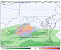
The ‘unintended benefit’ of the poleward jet is the NPac Low > Strat stretching so at least there’s thatLooks like the biggest forcing mech heading forward is gonna be that Rossby wave that backs up around 150E into mid Jan, you can see it getting going towards the end of the EPS. favors a equatorward shift of the pac jet but not exactly telling on how far it extends per say, it’s still kinda hard to see a coherent MJO signal on modeling/ens other then convection wisely distributed here and there. For next week it seems like what killed our look is actually to much pacific jet And poleward shifted at that from the +EAMT event. Not shocking honestly, a lot of the times after a +EAMT event you start out with a extension and poleward shifted jet before it shifts equatorward View attachment 180585View attachment 180586View attachment 180587
You can also see how it’s killing our threat next week, the trend to an earlier break is pushing the trough further east in the western US, raising heights out in the eastern US. Small sacrifice for a bigger cause I guessThe blueprints to the western ridge is already in the day 7-8 range, the associated break in the pacific is already beginning next week around this time, you can actually see it improving. It’s also making next weeks “threat” go to zilch View attachment 180610
Depends on if the small sacrifice was the only one we were gonna get this year. Then it becomes a large sacrifice.You can also see how it’s killing our threat next week, the trend to an earlier break is pushing the trough further east in the western US, raising heights out in the eastern US. Small sacrifice for a bigger cause I guess
vodka cold western ridge right there. Lol View attachment 180607View attachment 180608
Honestly even if we did go through we the look, temp anoms wasn’t very great, cold/thermos was definitely gonna be a issue with it, and while there was a few good analogs, most of them weren’t great for us, but rather the mid-Atlantic/lower NE. Not saying it couldn’t have happened, and it still could if something changes, but the look wasn’t very cold. I’d rather take a chance with some western US/alaskan ridgingDepends on if the small sacrifice was the only one we were gonna get this year. Then it becomes a large sacrifice.
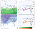
Yeah the Weeklies looked solid mid month, but thereafter, it looked like they were waving bye-bye to winter as the pattern retroed west. Hopefully Asia can help us out though with a bit of +EAMT momentum to extend things post mid monthDoing another one of these… Jan temp forecast. far more difficult and more likely to bust then December given there’s not really a true MJO driving this. which December did have a MJO progression before it fell apart, making it a rather easier forecast. first week of Jan could skew warm due to the jet extending poleward, but gonna go out on a limb that eventually -EPO driven cold will take over anoms by week 2.5-4 of Jan, and the reason for the warmer lower SE is because I do believe there will be some retrogression in the NPAC which could end Jan warmer unless we find another way to reinforce a jet extension, and when you warm up ahead of a Arctic temp gradient, they tend to be rather warm. Think coldest period will be mid month (wk 3) for the SE View attachment 180601
Thats honestly not a bad look considering the trends of the block..will maybe retrograde a bit and be just cold enough to not suppress a wave and bring us joy.We are so back to tracking Barney cold and dry (* ducks and hides…I know some hate that but I’m good with it - I’ve seen enough rain and 40 degrees in my lifetime lol)
View attachment 180609
Hopefully not if you like having electric power. Duke Energy came very close to losing the grid in the Carolinas on Christmas Eve 2022. The TVA also had a lot of trouble that dayJanuary 2014 says hello.


Looks good! How about that SW energy???Western ridging gaining traction on the GEFSAI ensView attachment 180618 View attachment 180615View attachment 180616
Find out in 378 hours!Looks good! How about that SW energy???

You must have some secret access....where you get it so early??Before anyone even posts it, the end of the ECAI does not resemble the ENS mean so there.


GEFS looking better….going super -AO and hemispheric ridgeThis is just a bit concerning View attachment 180626View attachment 180627

I do recall the +TNH being aggravating with not driving cold far enough south during portions of the 13-14 and 14-15 winters (with -NAO lacking). And when it does break farther south, hard to sync cold with storms too.....but again, I prefer getting more cold air in here and worry about storms laterThis is just a bit concerning View attachment 180626View attachment 180627
We are always going to dance with the SER in this pattern. Id be more concerned if the ridge axis was leaking west out west.This is just a bit concerning View attachment 180626View attachment 180627
Same, and if you remember last January there was a point when models way oversold the SE ridge resistance just 7-10 days out and the storm ended up dumping snow in the Gulf.View attachment 180630I do recall the +TNH being aggravating with not driving cold far enough south during portions of the 13-14 and 14-15 winters (with -NAO lacking). And when it does break farther south, hard to sync cold with storms too.....but again, I prefer getting more cold air in here and worry about storms later

Coming back to this. Even though the ECAI was a bit west with the western ridge going up, it was nice and aggressive here with the Pac Jet extension....looks good here.Before anyone even posts it, the end of the ECAI does not resemble the ENS mean so there.


????@LukeBarrette will you stop
These are valuable remindersSame, and if you remember last January there was a point when models way oversold the SE ridge resistance just 7-10 days out and the storm ended up dumping snow in the Gulf.View attachment 180630View attachment 180633
Brother it’s the 18z Euro life comes at you fast????
Where did this come from
View attachment 180592View attachment 180593View attachment 180594Something that *might* have some merit is what Bam has been talking about with the -AAM/MJO correlation and in the traditional sense phase 6 is warm, but they’re argument is in January the -AAM/MJO combo feeds the cold pattern because it enhances the EPO. Hoping that’s the outcome here.
Additionally, they were talking about the brief warmup ahead of the main cold pattern given Indian Ocean convection. They’ve done pretty well lately.
Appreciate the research man. I can’t argue with documentation. And absolutely I would rather 8, 1, 2.I did the analysis of the 15 Jans with phase 6 during La Niña (1975-2025)
Year….# phase 6 days…avg anomaly
1975…3…-8
1976…13…-9
1989…3…+8
1999…3…+2
2000…3…-4
2006…6…+3
2008…3…+8
2009…6…+1
2011…12…-7
2012…19…+1
2017…2…0
2018…3…-2
2021…8…-1
2022…4…-9
2025…2…-5
—————
91 total days that averaged ~-2
3 MBN
3 BN
6 NN
1 AN
2 MAN
BAMwx said that the phase 6 MJO/-AAM analogs had this at ~-6 to -7. So, I believe based on the above analysis that this is a good bit overdone and should be ~-2. Granted, it came in cool on average with the -2 anomaly, which to me is admittedly a bit counterintuitive. And 1975, 1976, 2011, and 2022 came in quite cold during their Jan phase 6 days showing it would be doable. But one can see that only 6 of the 15 (40%) Jans during phase 6 were in BAMwx’s cold vicinity.
I’d still much rather it go 8-1-2.
Any comments?
I did the analysis of the 15 Jans with phase 6 during La Niña (1975-2025)
Year….# phase 6 days…avg anomaly
1975…3…-8
1976…13…-9
1989…3…+8
1999…3…+2
2000…3…-4
2006…6…+3
2008…3…+8
2009…6…+1
2011…12…-7
2012…19…+1
2017…2…0
2018…3…-2
2021…8…-1
2022…4…-9
2025…2…-5
—————
91 total days that averaged ~-2
3 MBN
3 BN
6 NN
1 AN
2 MAN
BAMwx said that the phase 6 MJO/-AAM analogs had this at ~-6 to -7. So, I believe based on the above analysis that this is a good bit overdone and should be ~-2. Granted, it came in cool on average with the -2 anomaly, which to me is admittedly a bit counterintuitive. And 1975, 1976, 2011, and 2022 came in quite cold during their Jan phase 6 days showing it would be doable. But one can see that only 6 of the 15 (40%) Jans during phase 6 were in BAMwx’s cold vicinity.
I’d still much rather it go 8-1-2.
Any comments?
Love this look! Warm AK is always a win!This is just a bit concerning View attachment 180626View attachment 180627


Love this look! Warm AK is always a win!
Bingo!!How can we torch at the same time as AK?
Sent from my iPhone using Tapatalk
Man I was thinking the same thing yesterday!Bingo!!
One will be wrong! I hope it’s our torch!
This is a lot like chasing the 2018 new years pattern change to cold! Just slightly later
Looks like the models cant play catchup with the pattern. I am not as versed as some here and Im confused by whats being displayed.Bingo!!
One will be wrong! I hope it’s our torch!
This is a lot like chasing the 2018 new years pattern change to cold! Just slightly later
Alaska not torching lolHow can we torch at the same time as AK?
Sent from my iPhone using Tapatalk