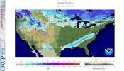
It’s called WinterRed map enthusiasts in shambles View attachment 178427
- some random guy on Facebook or Twitter
It’s called WinterRed map enthusiasts in shambles View attachment 178427
The trough has been too far east lately or no? I feel a retrograde would help out some imoWith the SOI taking going forward and more westerly wind bursts forecasted, any -EAMT should be on the weaker side. As Grit said, we'll have to wait til Dec 15th -20th or so for +EAMT chances that'll add momentum to the Pacific jet!
Arctic blast backing off for the Southeast. Been the trend since last night. I wonder if we reverse this over the coming days.
This is the first time in awhile we've ticked in the opposite direction for cold in the medium term. Might just be delayed though.
View attachment 178430

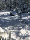
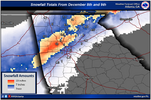
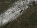
Yes I believe it was 8 years ago Monday night (8th going into the 9th). I was staying at a hotel in Carrollton visiting family. I drove down from Indiana and was so excited ! I measured 8 inches. There was about a foot not far away in Bremen !8 years ago today. The biggest surprise snow I’ve ever seen. Woke up expecting maybe a slushy inch or 2, ended up with 11 inches of concrete. It just kept snowing for 12 hours straight. Pure bliss. Hope to experience something similar again someday soon
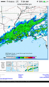
Check out that radar. When I woke up and saw this I knew we had a chance to overperform
View attachment 178468
View attachment 178470
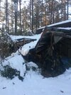
Roof of the shop out back collapsed from the weight
View attachment 178473View attachment 178472View attachment 178471View attachment 178474
See a lot of GFS forecasted torch LR this a.m.
Lets see how well the GFS that just ran at 6z NAILS DOWN the proceeding 24 hours. Hot off the press at 6z Monday, as snow is breaking out to our west.
View attachment 178483
It does?? It looks like 60° to me for Christmas
Yea I feel like we’re done through Christmas. Only positives are that there’s fresh deep cold in Canada and very good snow cover. We just have to to hope that cold drops in our direction post-Christmas. Mjo still looks good in the long range, so maybe that tips the odds in our favor for the end of the year.Nothing spells loosing like a monster LP parked up off the coast of Alaska / swallowing The NE Pacific, sitting there spinning its wheels. a Positive PNA, monster ridge up the west coast of US/Canada is always Numero UNO. Everything else, mjo, nao etc is fodder without proper ridging out there. Hope the models are off LR this a.m. in how they place, align everything. If not, are goose gets cooked from next weekend through Christmas.
Trof just anchors in place off Alaska on every ensemble and op. What a 180.
Yeah, it's hard to believe such a sudden 180 in LR, but there's something to it if they're all headed that way. Just figures headed into climo for us. Hopefully it doesn't last for a month, but it'll probably be 2-3 weeks anyway. IDKNothing spells loosing like a monster LP parked up off the coast of Alaska / swallowing The NE Pacific, sitting there spinning its wheels. a Positive PNA, monster ridge up the west coast of US/Canada is always Numero UNO. Everything else, mjo, nao etc is fodder without proper ridging out there. Hope the models are off LR this a.m. in how they place, align everything. If not, are goose gets cooked from next weekend through Christmas.
Trof just anchors in place off Alaska on every ensemble and op. What a 180.
Thats Christmas eveIt does?? It looks like 60° to me for Christmas
I know that and it's the LR GFS and so will Christmas Day. Mark my wordThats Christmas eve
CFS Latest run is awesome for my area post Christmas and as we flip into new year. But that can and will change a lot, long ways out. My area has been rewarded so far, thanks to CAD. Way below normal 8 days into Dec. so no complaints. Just hate to punt Dec 15-24. Have to see what evolves past that.Yea I feel like we’re done through Christmas. Only positives are that there’s fresh deep cold in Canada and very good snow cover. We just have to to hope that cold drops in our direction post-Christmas. Mjo still looks good in the long range, so maybe that tips the odds in our favor for the end of the year.
Let the game of kickin ole can down the road begin . lolBuzz your girlfriend woof at those LR models.
This is what I want for Christmas. Only December snow I want or care about.8 years ago today. The biggest surprise snow I’ve ever seen. Woke up expecting maybe a slushy inch or 2, ended up with 11 inches of concrete. It just kept snowing for 12 hours straight. Pure bliss. Hope to experience something similar again someday soon
Check out that radar. When I woke up and saw this I knew we had a chance to overperform
View attachment 178468
View attachment 178470
Roof of the shop out back collapsed from the weight
View attachment 178473View attachment 178472View attachment 178471View attachment 178474
CFS Latest run is awesome for my area post Christmas and as we flip into new year. But that can and will change a lot, long ways out. My area has been rewarded so far, thanks to CAD. Way below normal 8 days into Dec. so no complaints. Just hate to punt Dec 15-24. Have to see what evolves past that.
Good news is , if history repeats itself, the day 10-15 stuff will reverse back 180. Weve seen the models suck us into doom an gloom repeatedly advertising torch, only to correct themselves. Amazing how affected we are in the winter by what evolves off the coast of Alaska, NE Pacific
The same people clinging to the long range GFS must have missed the hurricane it had threatening south Florida yesterday morning.
