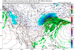
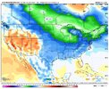
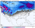
Do you think we’re looking at more climo favored areas this time around or is it possible to see some crazy stuff like the gulf had last year again?Predicting the future is hard in any business or hobby, but I have higher than normal confidence that the Dec 15 to Jan 15 period is going to be active and fun in here. Get the load testing done early boys!
View attachment 176660
-
Hello, please take a minute to check out our awesome content, contributed by the wonderful members of our community. We hope you'll add your own thoughts and opinions by making a free account!
You are using an out of date browser. It may not display this or other websites correctly.
You should upgrade or use an alternative browser.
You should upgrade or use an alternative browser.
Wintry Winter 25-26 Winter Battle Zone
- Thread starter SD
- Start date
Everyone should be in playDo you think we’re looking at more climo favored areas this time around or is it possible to see some crazy stuff like the gulf had last year again?
Boom! Let's see if we can bump that up to fantastic in the next week or two. Might as well shoot the moon!Predicting the future is hard in any business or hobby, but I have higher than normal confidence that the Dec 15 to Jan 15 period is going to be active and fun in here. Get the load testing done early boys!
View attachment 176660

There’s an option in there in an extreme scenario to take it all the way to the ground…flatlinedBoom! Let's see if we can bump that up to fantastic in the next week or two. Might as well shoot the moon!
View attachment 176661
This December nina coastal going to hit like Crack
Thats it. Go big or Go home! Worse that can happen is you will be wrong and fit in with everyone else in LR forecasting lol.There’s an option in there in an extreme scenario to take it all the way to the ground…flatlined
Im encouraged with this news coming from you. I value your opinion on LR outlooks as much as anyone. You always do your homework and call it like you see it, as well as include the caveats as to what could screw the pooch as things progress along. We all appreciate your post, research,thoughts on here.
I would love to see a good old fashioned southern slider sometime this winter with a goo wide swath of accumulations 4”+ from N AL to N GA to the western and central Carolinas. It’s been too long since we’ve seen thatThere’s nothing that gets me more excited than watching the Euro start to show a storm forming in Texas and seeing that snow line well south and coming this way. And not fizzle out the closer it gets.
Marion Berry?This December nina coastal going to hit like Crack
BrickTamland
Member
Yeah, I remember when that used to happen, too.There’s nothing that gets me more excited than watching the Euro start to show a storm forming in Texas and seeing that snow line well south and coming this way. And not fizzle out the closer it gets.
BrickTamland
Member
My washer can handle extra big loads.Boom! Let's see if we can bump that up to fantastic in the next week or two. Might as well shoot the moon!
View attachment 176661
BrickTamland
Member
The Nike Therma Fit pants are very cozy.Time to go pants shopping!
You must have been bored as s#!+ since 1988.There’s nothing that gets me more excited than watching the Euro start to show a storm forming in Texas and seeing that snow line well south and coming this way. And not fizzle out the closer it gets.
Iv seen plenty in fantasy land. That’s all I have to hold me over.You must have been bored as s#!+ since 1988.
CNCsnwfan1210
Member
Apparently, AI GFS and GEFS has rolled out today on weathermodels.com
Sent from my iPhone using Tapatalk
Sent from my iPhone using Tapatalk
Predicting the future is hard in any business or hobby, but I have higher than normal confidence that the Dec 15 to Jan 15 period is going to be active and fun in here. Get the load testing done early boys!
View attachment 176660
My own feeling is that the combo of a weak SPV in late Nov/early Dec along with a weak to moderate MJO since that’s on average when it’s coldest (preferably slow moving <1.5 amp phase 8 followed by slow moving near or inside COD phases 1 followed by 2 and 3) combined with Nina climo would give a good chance at a cold dominated E US 12/15-1/15. A lot is up to the MJO, which has struggled to get into phase 8 at all in Dec since 2010.
Last edited:
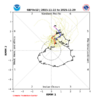
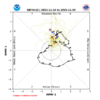
Strong run (18z) of the GFS with the SPV. Gets the 10mb zonal wind down to 0 m/s (SSW) at day 9, -16 m/s at day 16 (1st two images)
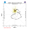
In the lower stratosphere, it gets the 100mb zonal wind down to 3 m/s ( 3rd image). In the NASA MERRA2 data, it looks like the lowest value recorded at 100mb in the late November timeframe since 1979 is around 2 m/s
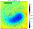
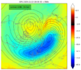
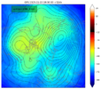
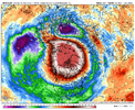
In the lower stratosphere, it gets the 100mb zonal wind down to 3 m/s ( 3rd image). In the NASA MERRA2 data, it looks like the lowest value recorded at 100mb in the late November timeframe since 1979 is around 2 m/s


Last edited:
That's a lot of red!Strong run (18z) of the GFS with the SPV. Gets the 10mb zonal wind down to 0 m/s (SSW) at day 9, -16 m/s at day 16 (1st two images)
In the lower stratosphere, it gets the 100mb zonal wind down to 3 m/s ( 3rd image). In the NASA MERRA2 data, it looks like the lowest value recorded in the late November timeframe since 1979 is around 2 m/s
View attachment 176668
View attachment 176669
View attachment 176670
View attachment 176672
MRKEVIN7575
Member
Goes to show you how difficult it can be to get a ssw event to try to manifestThat's a lot of red!
Brent
Member
It was 90 degrees in this state today.... One of the hottest days ever in November
Really hard to talk about winter anytime soon
Really hard to talk about winter anytime soon
Mack's got a rockin clouds and flowers disco going on in the Banter thread that might be worth checking out!It was 90 degrees in this state today.... One of the hottest days ever in November
Really hard to talk about winter anytime soon
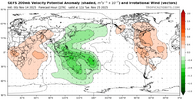
I like the look of this MJO wave. These images on TTidbits for the GEFS come out a day later (Nov 14 run shown here), but in the NOAA CPC MJO updates, they will refer to this as a Wave 1 pattern where you have one -VP zone (upper-level divergence / uplift / enhanced convection) extending here from the Maritime Continent to the W Pacific, and you have one +VP zone (upper-level convergence / subsidence / reduced convection) extending from E Pacific to Africa to W Indian Ocean. This is on Nov 25.My own feeling is that the combo of a weak SPV in late Nov/early Dec along with a weak to moderate MJO since that’s on average when it’s coldest (preferably slow moving <1.5 amp phase 8 followed by slow moving near or inside COD phases 1-2-3) combined with Nina climo would give a good chance at a cold dominated E US 12/15-1/15. A lot is up to the MJO, which has struggled to get into phase 8 at all in Dec since 2010.
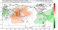
Fast forward to Dec 19 in the forecast, and you still have the Wave 1 pattern, but with uplift now in the E Pacific to Africa, and subsidence in W Indian Ocean to W Pacific.
And that matches with a Wave 1 MJO Phase 8 look as seen here from the JMA MJO VP composites.
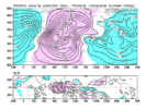
Bottom line: what I feel gives more confidence than normal with the long-range forecast is that this MJO wave is moving methodically / slowly, and in a Wave 1 pattern which should be more reliable with teleconnections. And it is quite normal for the MJO to have a slowdown as it moves thru the Maritime Continent and W Pacific. That slowdown is ongoing and will continue over the next 2 weeks, though forecasts are quite consistent that this Wave 1 pattern will continue pushing east thereafter. If this were a chopped up, Wave 2 pattern with multiple areas of uplift and multiple areas of subsidence across the tropics, which does happen at times, this would lead to less confidence in the MJO's influence on the pattern.
Iceagewhereartthou
Member
I LOVE this but I am feeling about the same as a snow enthusiast in SC as I am as a Gamecock fan. We just find new ways to crush hopes and break hearts every time. The parade always goes down somebody else's street. The sun always shines on a different dog. The stars always align for someone else. The only thing to count on is pain. Hope only leads to more pain. I need a hug.Predicting the future is hard in any business or hobby, but I have higher than normal confidence that the Dec 15 to Jan 15 period is going to be active and fun in here. Get the load testing done early boys!
View attachment 176660
trackersacker
Member
Was just thinking the other day about when you used to do these. Love to see it!Predicting the future is hard in any business or hobby, but I have higher than normal confidence that the Dec 15 to Jan 15 period is going to be active and fun in here. Get the load testing done early boys!
View attachment 176660
Don't worry. We good.I LOVE this but I am feeling about the same as a snow enthusiast in SC as I am as a Gamecock fan. We just find new ways to crush hopes and break hearts every time. The parade always goes down somebody else's street. The sun always shines on a different dog. The stars always align for someone else. The only thing to count on is pain. Hope only leads to more pain. I need a hug.
In the meantime, enjoy the INCREDIBLY nice weather through early December.
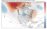
Webberweather53
Meteorologist
lexxnchloe
Member
LC throws hot water on a cold Dec, but gives hope for Jan-Mar
There will be a transient cold intrusion through the eastern two-thirds of North America November 28 - December 5. Then a new subtropical high appears close to the Bermuda position, and starts the warming process all over again. Another cold frontal passage is possible through the northern third of half of the U.S. in the second week of December, but most of the predictive schemes have backed off on the idea of a cold December. I am confident that set-up will change for January, February, and maybe the first week of March, a reaction to the rise of SST anomaly in the equatorial Pacific Basin (likely a positive neutral ENSO in the spring). This should be a well-defined "second half" or "back loaded" winter, when the powerful southern branch jet stream wears down the positive 500MB height anomaly in the southwestern Atlantic Ocean. For now, except for the occasional Alberta Clipper or Colorado/Trinidad "A" storm, it is a normal to warm prediction from Texas and the lower Great Plains through the Mississippi Valley to the Eastern Seaboard.
There will be a transient cold intrusion through the eastern two-thirds of North America November 28 - December 5. Then a new subtropical high appears close to the Bermuda position, and starts the warming process all over again. Another cold frontal passage is possible through the northern third of half of the U.S. in the second week of December, but most of the predictive schemes have backed off on the idea of a cold December. I am confident that set-up will change for January, February, and maybe the first week of March, a reaction to the rise of SST anomaly in the equatorial Pacific Basin (likely a positive neutral ENSO in the spring). This should be a well-defined "second half" or "back loaded" winter, when the powerful southern branch jet stream wears down the positive 500MB height anomaly in the southwestern Atlantic Ocean. For now, except for the occasional Alberta Clipper or Colorado/Trinidad "A" storm, it is a normal to warm prediction from Texas and the lower Great Plains through the Mississippi Valley to the Eastern Seaboard.
Prepared by Meteorologist LARRY COSGROVE on
Saturday, November 15, 2025, 2022 at 11:30 P.M. CT
Saturday, November 15, 2025, 2022 at 11:30 P.M. CT
Should be fun to see who’s wrong and who’s right.LC throws hot water on a cold Dec, but gives hope for Jan-Mar
There will be a transient cold intrusion through the eastern two-thirds of North America November 28 - December 5. Then a new subtropical high appears close to the Bermuda position, and starts the warming process all over again. Another cold frontal passage is possible through the northern third of half of the U.S. in the second week of December, but most of the predictive schemes have backed off on the idea of a cold December. I am confident that set-up will change for January, February, and maybe the first week of March, a reaction to the rise of SST anomaly in the equatorial Pacific Basin (likely a positive neutral ENSO in the spring). This should be a well-defined "second half" or "back loaded" winter, when the powerful southern branch jet stream wears down the positive 500MB height anomaly in the southwestern Atlantic Ocean. For now, except for the occasional Alberta Clipper or Colorado/Trinidad "A" storm, it is a normal to warm prediction from Texas and the lower Great Plains through the Mississippi Valley to the Eastern Seaboard.
Prepared by Meteorologist LARRY COSGROVE on
Saturday, November 15, 2025, 2022 at 11:30
MRKEVIN7575
Member
Im assuming with the mjo moving very slow, it will delay it getting colder than first thought in first half December. Delayed but not denied hopefully
Was thinking about this when looking at the maps last night. We’re going from a +EPO (warm, not snowy Canada) to a -PNA (cold, snowy Canada) to hopefully a better pattern down this way down the line. It’s the right way to get to the end goal (I know you’ve mentioned this in a prior post). It’s much better than going from +EPO to trying to quickly turn it wintry down hereA slow, methodical pattern change is the right way to do this in the long run.
Snow cover should build and fill in to our north as this -PNA pattern persists at the end of Nov into the beginning of Dec.
We’re setting ourselves up nicely down the road
View attachment 176687
tennessee storm
Member
Don’t go in cod? Who knowsIm assuming with the mjo moving very slow, it will delay it getting colder than first thought in first half December. Delayed but not denied hopefully
Webberweather53
Meteorologist
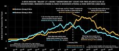
I remember sharing this graph during the 2023-24 Nino winter.
Snowfall-wise on the East Coast, bigger La Niña winters usually do most of their damage (relative to El Niños) in late Dec and early January. Though this year isn’t a stronger Nina per say, we’ve been basically following the typical Nina theme this year
Don’t see why this year won’t try to follow the same overall trend

View attachment 176686Looks better. Faster progression through 7.
It’s consistent with the prior run, which is fine with me:
Yesterday’s extended EPS:
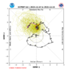
Today’s extended EPS:

Drizzle Snizzle
Member
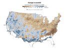
The southern parts of Georgia and Alabama seem to be doing well the last few years !This is pathetic. Biggest departure in the nation along 85 from Atlanta to Charlotte. Matches perfectly with my own personal measurements and have only roughly 30% of normal snowfall since 2018. So areas west of here, we arent just complaining to complain. It's a legit dumpster fire here.
View attachment 176689


