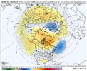
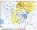
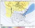
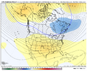
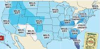
Ain’t no way the SE in the forecast gets more snow then NYC.BAM Weather had a free webinar today. I couldn't listen to it, but here's their forecast.
View attachment 176048
View attachment 176049
View attachment 176050
-
Hello, please take a minute to check out our awesome content, contributed by the wonderful members of our community. We hope you'll add your own thoughts and opinions by making a free account!
You are using an out of date browser. It may not display this or other websites correctly.
You should upgrade or use an alternative browser.
You should upgrade or use an alternative browser.
Wintry Winter 25-26 Winter Battle Zone
- Thread starter SD
- Start date
Looking at those temperature maps, they look promising for December and January. I hope we can score before February if this forecast pans out. Below normal precipitation is one feature that comes with the territory with a weak La Nina in place.BAM Weather had a free webinar today. I couldn't listen to it, but here's their forecast.
View attachment 176048
View attachment 176049
View attachment 176050
SnowNiner
Member
We have a slowdown of the MJO in Phase 5
View attachment 176042
But that was forecasted and may be good news depending on how you want to view Dec-Jan. I think the JMA has a good middle of the road forecast here of the MJO getting into lower amp Phase 7 by mid-Nov.
View attachment 176043
Similar on the Euro Wk as it shows a slow trek in Phase 7 thereafter into early Dec.
View attachment 176045
A good target in my mind would be a slow trek thru phases 7-8-1-2-3 from late Nov to early-mid Jan. We had that type of slow trek in Dec-Jan 2021-2022 (Nina with very similar -QBO structure as this winter / low amp MJO toward the end), albeit a little later then (early Dec to late Jan)
View attachment 176046
View attachment 176047
Expected turn, but painful to watch. Really hope it keeps going 8-2 and doesn't stay on the right, as that seems to me the biggest driver of our colder patterns of late. Convection in the pacific, the jet alignment makes all the difference. Any red flags that would make it stay in the maritime?
BAM Weather had a free webinar today. I couldn't listen to it, but here's their forecast.
View attachment 176048
View attachment 176049
View attachment 176050
I'd take that in a heartbeat if we could get it in reality. What's funny is that no matter the variable, every winter February is now the first month of spring.....always. That's the only month they're higher confidence on. lol.
Yeah so these are just saying that they expect more snow compared to normal in parts of the SE, with NYC below normal snowfall...not actual snowfall amounts.Ain’t no way the SE in the forecast gets more snow then NYC.
Some people rail on BAM, but they are good forecasters from what I've seen over the past few years. Do they get a little excited? Yes, but hey, so do we in here. That's all part of it. No forecaster in the world gets it right all the time
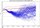
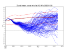
After a tick rise in the Strat PV strength chart yesterday, there was a fall today, centered around Nov 25-26. Bottom line, we want it weaker than normal (dark red line is normal), especially in the lower strat around 100mb (not shown here as this is for the upper strat at 10mb, but in this type of setup, and with the models favoring some level of high latitude blocking going forward, the upper strat and lower strat should be somewhat similar in behavior)

Webberweather53
Meteorologist
La Niña is living on borrowed time.
The only reason the extreme -IOD event we're currently seeing is going to collapse is because all of the warm water is about to get flushed into the tropical west pacific at depth over the next month or two in this MJO event's westerly wind burst. Another solid subsequent MJO burst over the West Pacific later in the winter would lead to rapid onset of El Nino conditions this spring.
A more rapid shift towards El Niño is probably the one wild card we could play that would have the potential to significantly alter the outcome of the latter part of this winter/February in our favor (though even then it wouldn't be a guarantee that things would shift favorably even in that scenario).

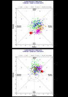
Things seem to be moving along nicely so far. Here is the Euro Wk MJO. 1st image is MJO forecast from Oct 16. 2nd image is MJO forecast from Nov 5. Green dots are ensemble members for Day 20 of the forecast. End of black line is 30 day forecast (I believe, as it says Monthly forecast and that seems to make sense) - so early Dec in Phase 7Expected turn, but painful to watch. Really hope it keeps going 8-2 and doesn't stay on the right, as that seems to me the biggest driver of our colder patterns of late. Convection in the pacific, the jet alignment makes all the difference. Any red flags that would make it stay in the maritime?
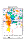
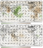
Also, on the VP maps from today's weeklies, we can see the -VP signal in green (upper divergence / uplift / enhanced convection) in the E Maritime Continent (Phase 5) for Nov 5-12 avg....with that signal out of the MC and uplift over S America in the 2nd image for Dec 14-21 (Phase 8-1 type look). Sure, the Weeklies can leave us standing at the altar, but they seem to follow the general idea of MJO expectations from what I've seen and gathered.
Webberweather53
Meteorologist
Things seem to be moving along nicely so far. Here is the Euro Wk MJO. 1st image is MJO forecast from Oct 16. 2nd image is MJO forecast from Nov 5. Green dots are ensemble members for Day 20 of the forecast. End of black line is 30 day forecast (I believe, as it says Monthly forecast and that seems to make sense) - so early Dec in Phase 7
View attachment 176056
Also, on the VP maps from today's weeklies, we can see the -VP signal in green (upper divergence / uplift / enhanced convection) in the E Maritime Continent (Phase 5) for Nov 5-12 avg....with that signal out of the MC and uplift over S America in the 2nd image for Dec 14-21 (Phase 8-1 type look). Sure, the Weeklies can leave us standing at the altar, but they seem to follow the general idea of MJO expectations from what I've seen and gathered.
View attachment 176057
The negative NAO in late November into December is pretty key & favorable to communicating this upper-level footprint of the MJO into the Western Hemisphere
Webberweather53
Meteorologist
La Niña is living on borrowed time.
The only reason the extreme -IOD event we're currently seeing is going to collapse is because all of the warm water is about to get flushed into the tropical west pacific at depth over the next month or two in this MJO event's westerly wind burst. Another solid subsequent MJO burst over the West Pacific later in the winter would lead to rapid onset of El Nino conditions this spring.
A more rapid shift towards El Niño is probably the one wild card we could play that would have the potential to significantly alter the outcome of the latter part of this winter/February in our favor (though even then it wouldn't be a guarantee that things would shift favorably even in that scenario).
View attachment 176055
The negative NAO in late November into December is pretty key & favorable to communicating this upper-level footprint of the MJO into the Western Hemisphere
Getting an MJO event to orbit into the Western Hemisphere (phase 8-1) a majority of the time relies on the extratropical circulation carrying the signal along, because the SSTs aren't warm enough outside of the Indo-Pacific to couple directly with the ocean, except perhaps in big El Niño events.
Having a negative NAO makes these western hemisphere MJO orbits more likely to occur because the extratropical waves penetrate deeper into the tropics during -NAO:
You can basically think of this as a positive feedback, where the presence of a -NAO makes a phase 8-1 MJO more likely to occur, which also favors -NAO, etc.
https://journals.ametsoc.org/view/journals/clim/34/23/JCLI-D-21-0153.1.xml
I reviewed the paper you shared on this earlier and it appears to state the exact opposite. It clearly states that a negative NAO often lags an eventual MJO in P3 and a positive NAO lags an eventual NAO in P7.
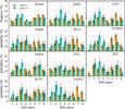
Observed 21–30-day lagged occurrence frequency of MJO phases following positive and negative NAO in extended winters of 1981–2017. The remaining panels show the probability of occurrence of MJO phases in the forecast period of 21–30 days initialized with positive and negative NAO for individual S2S models. The vertical bars represent the 95% level of confidence from a 10 000 bootstrap resampling calculation.
In this study, based on the reforecast data of 11 models of the WWRP/WCRP S2S project, the influence of the NAO prediction of the MJO is investigated. It is found that most models are able to reproduce the MJO phase change following the occurrence of positive and negative NAO events. About three weeks after a positive NAO, there is increased probability of MJO phase 7, while about three weeks following a negative NAO, MJO phase 3 is more likely to occur.
They theorized this relationship could be due to the following, but it doesn't sound like a definitive explanation:
One possible explanation is that following an NAO event, which has a dipole Z200 anomaly structure in the Greenland and midlatitude North Atlantic regions, there is a slow southward propagation of energy, so that with time the amplitude of the Greenland anomaly center is reduced and a subtropical center develops and enhances. After about 2–3 weeks, wave activity flux converges in the subtropical North Atlantic, causing a local zonal wind acceleration that acts as a forcing on the tropics. As a result, an equatorial Kelvin wave is excited to the east in the region with an easterly mean flow over the tropical Indian Ocean, leading to strong zonal wind anomalies, thereby influencing the MJO. However, questions related to the detail of this process, what controls the southward wave energy propagation, and how the extratropical forcing excites the tropical Kelvin remain unclear.
Not trying to be argumentative, but I am curious how you come to the seemingly definitive conclusion that a negative NAO makes a phase 8-1 MJO subsequently more likely to occur when the paper you cited appears to state the opposite?
Webberweather53
Meteorologist
I reviewed the paper you shared on this earlier and it appears to state the exact opposite. It clearly states that a negative NAO often lags an eventual MJO in P3 and a positive NAO lags an eventual NAO in P7.
View attachment 176064
Observed 21–30-day lagged occurrence frequency of MJO phases following positive and negative NAO in extended winters of 1981–2017. The remaining panels show the probability of occurrence of MJO phases in the forecast period of 21–30 days initialized with positive and negative NAO for individual S2S models. The vertical bars represent the 95% level of confidence from a 10 000 bootstrap resampling calculation.
They theorized this relationship could be due to the following, but it doesn't sound like a definitive explanation:
Not trying to be argumentative, but I am curious how you come to the seemingly definitive conclusion that a negative NAO makes a phase 8-1 MJO subsequently more likely to occur when the paper you cited appears to state the opposite?
No worries. It’s actually all part of the same large scale slowly evolving subseasonal process! This takes many, many weeks to fully transpire of course
(I.e. western pacific mjo >> -NAO/western hemisphere mjo >> Indian Ocean MJO >> +NAO >> western pacific mjo >> & so on/so forth)
What you are describing is a multi-week positive lagged relationship between the -NAO & Indian Ocean MJO, which argues for eventual MJO propagation into the Indian Ocean, but likely not until the mid-latter part of December or so. It doesn’t however address what happens prior to that, because the MJO signal has to be first communicated upstream thru the Western Hemisphere before it reaches the Indian Ocean weeks later.
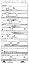
The extratropical circulation pattern is of course key in determining whether or not an MJO event is carried across the western hemisphere because the upper-level footprint of the MJO is usually all the evidence we have of an MJO event occurring outside the Indo-Pacific Warm Pool. Oth, during the northern summer the NE Pacific is warm enough to readily couple to the atmosphere and changes this signature somewhat.
From Zhang (2005): https://agupubs.onlinelibrary.wiley.com/doi/full/10.1029/2004RG000158
The Euro weeklies also do hint at another Indian Ocean MJO orbit happening as we approach the Solstice (~Dec 21) fwiw, which is consistent with this study (& something I can agree with), but also not totally inconsistent with what’s being argued in my earlier post wrt an early December western hemisphere MJO.
Regardless, what has been really encouraging to me for the last week or two is knowing the lagged relationship between Indian Ocean MJO and the positive phase of the NAO is usually muted in La Niña winters like this one due to greater zonal separation between the pacific and Atlantic jet streams.
If we also couple this -NAO with the weaker stratospheric vortex (which too seems more likely given how the -NAO is being timed up with the stratospheric warming as discussed earlier in this thread), this would make it more difficult for +NAO to occur at positive lag from an Indian Ocean MJO event. Of course, in that case we’d talking about early January or so, so things can certainly change and I personally do not have super high confidence in how January pans out yet. I do suspect however we will eventually break thru with a more positive NAO/AO, but it may take a “wave reflection” type event from an -EPO/+TNH pattern later in January coupling with a recovering polar vortex from this very early winter disruption/weakening event to make it happen.
https://agupubs.onlinelibrary.wiley.com/doi/full/10.1029/2019GL084683
I'll agree that the potential weakened SPV (if it indeed comes to pass, which I do have more confidence in for reasons discussed earlier) is a great harbinger of increased potential for blocking heading into December. In fact, I give guest lectures to school students and one of my most-requested topics is always the winter outlook and I always include the December SPV forecast and historical analyses as part of that outlook. We've certainly had some of our better Decembers with a weakened SPV and we've had some real duds the other way (to no ones surprise).No worries. It’s actually all part of the same large scale slowly evolving subseasonal process! This takes many, many weeks to fully transpire of course
(I.e. western pacific mjo >> -NAO/western hemisphere mjo >> Indian Ocean MJO >> +NAO >> western pacific mjo >> & so on/so forth)
What you are describing is a multi-week positive lagged relationship between the -NAO & Indian Ocean MJO, which argues for eventual MJO propagation into the Indian Ocean, but likely not until the mid-latter part of December or so. It doesn’t however address what happens prior to that, because the MJO signal has to be first communicated upstream thru the Western Hemisphere before it reaches the Indian Ocean weeks later.
The extratropical circulation pattern is of course key in determining whether or not an MJO event is carried across the western hemisphere because the upper-level footprint of the MJO is usually all the evidence we have of an MJO event occurring outside the Indo-Pacific Warm Pool. Oth, during the northern summer the NE Pacific is warm enough to readily couple to the atmosphere and changes this signature somewhat.
From Zhang (2005): https://agupubs.onlinelibrary.wiley.com/doi/full/10.1029/2004RG000158
View attachment 176067
The Euro weeklies also do hint at another Indian Ocean MJO orbit happening as we approach the Solstice (~Dec 21) fwiw, which is consistent with this study (& something I can agree with), but also not totally inconsistent with what’s being argued in my earlier post wrt an early December western hemisphere MJO.
Regardless, what has been really encouraging to me for the last week or two is knowing the lagged relationship between Indian Ocean MJO and the positive phase of the NAO is usually muted in La Niña winters like this one due to greater zonal separation between the pacific and Atlantic jet streams.
If we also couple this -NAO with the weaker stratospheric vortex (which too seems more likely given how the -NAO is being timed up with the stratospheric warming as discussed earlier in this thread), this would make it more difficult for +NAO to occur at positive lag from an Indian Ocean MJO event. Of course, in that case we’d talking about early January or so, so things can certainly change and I personally do not have super high confidence in how January pans out yet. I do suspect however we will eventually break thru with a more positive NAO/AO, but it may take a “wave reflection” type event from an -EPO/+TNH pattern later in January coupling with a recovering polar vortex from this very early winter disruption/weakening event to make it happen.
https://agupubs.onlinelibrary.wiley.com/doi/full/10.1029/2019GL084683
Looking for ways this goes off the rails (the potential for a fast start to winter) is where the MJO certainly has to be considered, and the potential that the negative NAO we're currently experiencing could actually interfere with the pass into the western Hemisphere is what has my attention. It's not something I'd expect models (certainly not the weeklies, which are not reliable IMO) to latch onto ahead of time, so that is where I'm coming from in being concerned about a "rug pull". I'm cautiously optimistic, but I've got to see definitive evidence the MJO continues on into P8-1 before I move into the excited camp for first half of December.
Webberweather53
Meteorologist
I'll agree that the potential weakened SPV (if it indeed comes to pass, which I do have more confidence in for reasons discussed earlier) is a great harbinger of increased potential for blocking heading into December. In fact, I give guest lectures to school students and one of my most-requested topics is always the winter outlook and I always include the December SPV forecast and historical analyses as part of that outlook. We've certainly had some of our better Decembers with a weakened SPV and we've had some real duds the other way (to no ones surprise).
Looking for ways this goes off the rails (the potential for a fast start to winter) is where the MJO certainly has to be considered, and the potential that the negative NAO we're currently experiencing could actually interfere with the pass into the western Hemisphere is what has my attention. It's not something I'd expect models (certainly not the weeklies, which are not reliable IMO) to latch onto ahead of time, so that is where I'm coming from in being concerned about a "rug pull". I'm cautiously optimistic, but I've got to see definitive evidence the MJO continues on into P8-1 before I move into the excited camp for first half of December.
There's a lot of coupled 2-way interactions between the MJO, NAO, and stratosphere that are hard for the models to capture, but the negative NAO here would only serve to try & enhance the western hemisphere propagation in early December (& eventually an Indian Ocean orbit in mid-late December or so). The current low frequency base state is also not particularly favorable yet for western troughing/-PNA & the bout of western roughing in mid-late November will imho be a temporary blip in the grand scheme of things until we get much later in the winter.
Models (esp the EPS when initializing an MJO event over the Maritime Continent) also typically have a weak/fast bias with the MJO in the extended range & I think they'll likely correct with more amplitude, though not as much as the GEFS showed earlier.
The other thing that makes me think the MJO will continuously propagate through the Western Hemisphere is the ongoing easterly QBO & the potential for increased tropical upwelling due to an acceleration of the Brewer Dobson Circulation as the polar stratosphere warms later in November. This increased tropical upwelling adiabatically cools the tropical upper troposphere and lower-middle stratosphere, amplifying tropical convection through cloud radiative feedbacks, etc..
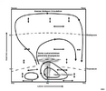
In MERRA-2, this increased tropical upwelling & cooling of the tropical lower stratosphere has been observed during sudden stratospheric warming events.
The impacts of sudden stratospheric warming events on the Brewer Dobson Circulation and tropical convection were documented nearly 20 years ago following the very rare 2002 sudden stratospheric warming event/major disruption of the antarctic polar vortex.
Impact of the 2002, Southern Hemisphere, stratospheric warming on the tropical cirrus clouds and convective activity
Webberweather53
Meteorologist
Inspired by the study @griteater shared with us a few days ago, I replicated their QBO/Solar analysis on subseasonal variability of the polar vortex, but used a lot more data, looked only at cool neutral and La Niña winters, and utilized NOAA 20th Century Reanalysis SLP to analyze surface variability in the polar vortex.
In order to increase the sample size of the data I had to play with, I also used this pre-1953 QBO reconstruction from Bronnimann et al (2007) to analyze early 20th century QBO behavior.
View attachment 175897
Breaking down things by month revealed some very interesting behavior. I highlighted this year's current solar/QBO combo (High solar/East QBO) for reference (Warm colors = High SLP, Cold Colors = Low SLP). There's of course a lot of variability still within each sub-composite, but it was neat to see what this looked like anyway.
High Solar/East QBO/-ENSO winters like this one historically tend to have a weaker polar vortex & -NAO in December and January, and usually see a rather sudden & dramatic flip of the AO/NAO to positive (or even strongly positive) during February, with the positive AO/NAO lasting into at least March.
One thing you can honestly say about High Solar/East QBO winters like this year compared to other cool ENSO cases is that outside of January, they tend to follow the typical La Niña paradigm (far right column) more than most. (i.e. a front-loaded winter).
View attachment 175896
Circling back around to this post, I see why the AO/surface Northern Annular Mode (NAM) evolves like this in east QBO/solar max winters.
This study lays this dynamical mechanism out pretty clearly:
https://agupubs.onlinelibrary.wiley.com/doi/full/10.1002/2015JD024460
Basically, the easterly qbo strengthens the brewer-dobson circulation, leading to more upwelling/cooling in the tropical stratosphere. This upwelling increases ozone levels in the mid-upper stratosphere of the tropics and a causes an accumulation of ozone over the polar stratosphere. High solar activity thru energetic particle precipitation then catalyzes/accelerates ozone destruction in the polar stratosphere (thru HOx and NOx radicals), which causes the polar stratosphere to preferentially cool. The stratosphere meridional temperature gradient then increases between the poles and the tropics, causing the westerly winds in the stratosphere to intensify. These circulation anomalies in the stratosphere then progressively propagate downward into the troposphere, anchoring themselves to the surface by February & March.
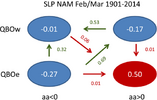
The SLP/surface NAM, QBO, and solar activity analysis from this study agrees with what I showed in the quoted post, w/ the AO/NAO being the most positive in Feb-Mar during east QBO/solar max winters like this year:
Webberweather53
Meteorologist
Circling back around to this post, I see why the AO/surface Northern Annular Mode (NAM) evolves like this in east QBO/solar max winters.
This study lays this dynamical mechanism out pretty clearly:
https://agupubs.onlinelibrary.wiley.com/doi/full/10.1002/2015JD024460
Basically, the easterly qbo strengthens the brewer-dobson circulation, leading to more upwelling/cooling in the tropical stratosphere. This upwelling increases ozone levels in the mid-upper stratosphere of the tropics and a causes an accumulation of ozone over the polar stratosphere. High solar activity thru energetic particle precipitation then catalyzes/accelerates ozone destruction in the polar stratosphere (thru HOx and NOx radicals), which causes the polar stratosphere to preferentially cool. The stratosphere meridional temperature gradient then increases between the poles and the tropics, causing the westerly winds in the stratosphere to intensify. These circulation anomalies in the stratosphere then progressively propagate downward into the troposphere, anchoring themselves to the surface by February & March.
The SLP/surface NAM, QBO, and solar activity analysis from this study agrees with what I showed in the quoted post, w/ the AO/NAO being the most positive in Feb-Mar during east QBO/solar max winters like this year:
View attachment 176072
Understanding the late winter & spring behavior of the NAM/AO & NAO is important for the winter & spring and arguably the rest of 2026 too. Positive NAM/AO in late winter-spring makes the Seasonal Footprinting Mechanism (SFM) & North Pacific Oscillation (NPO) pattern more effective at triggering El Niño during the subsequent year.
The North Pacific Oscillation this winter has looked very supportive in model forecasts for several months to the development of this SFM next spring, which would lean heavily towards El Niño next year.
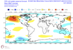
This negative NPO/SFM pattern has also been present in the winters prior to the 2 most recent El Niño events in 2018-19 & 2023-24:
MRKEVIN7575
Member
Is the subsurface cold enough to still lean weak east based Niña?Circling back around to this post, I see why the AO/surface Northern Annular Mode (NAM) evolves like this in east QBO/solar max winters.
This study lays this dynamical mechanism out pretty clearly:
https://agupubs.onlinelibrary.wiley.com/doi/full/10.1002/2015JD024460
Basically, the easterly qbo strengthens the brewer-dobson circulation, leading to more upwelling/cooling in the tropical stratosphere. This upwelling increases ozone levels in the mid-upper stratosphere of the tropics and a causes an accumulation of ozone over the polar stratosphere. High solar activity thru energetic particle precipitation then catalyzes/accelerates ozone destruction in the polar stratosphere (thru HOx and NOx radicals), which causes the polar stratosphere to preferentially cool. The stratosphere meridional temperature gradient then increases between the poles and the tropics, causing the westerly winds in the stratosphere to intensify. These circulation anomalies in the stratosphere then progressively propagate downward into the troposphere, anchoring themselves to the surface by February & March.
The SLP/surface NAM, QBO, and solar activity analysis from this study agrees with what I showed in the quoted post, w/ the AO/NAO being the most positive in Feb-Mar during east QBO/solar max winters like this year:
View attachment 176072
Webberweather53
Meteorologist
Is the subsurface cold enough to still lean weak east based Niña?
More than plenty cold enough for the time being.
Im not too concerned about a significant ENSO transition until perhaps March.
The first MJO orbit thru the Indo-Pacific here is establishing the warm water volume in the tropical western pacific. The next MJO event later this winter in the west pac will likely advect this warm water eastward along the thermocline in the form of a downwelling Kelvin Wave, with some enso transition 2-3 months lagged from that.
MRKEVIN7575
Member
I guess what I'm getting at is in the winter 21-22, it was a pretty robust east based niña. We blowtorched in December, which allowed djf to average above normal. After January 1st it got stormier and colder. With a weaker eastward leaning niña, it would seem like stormier earlier and colder but last longer than people think, UNLESS radical changes were to happen.More than plenty cold enough for the time being.
Im not too concerned about a significant ENSO transition until perhaps March.
The first MJO orbit thru the Indo-Pacific here is establishing the warm water volume in the tropical western pacific. The next MJO event later this winter in the west pac will likely advect this warm water eastward along the thermocline in the form of a downwelling Kelvin Wave, with some enso transition 2-3 months lagged from that.
Webberweather53
Meteorologist
Tsappfrog20
Member
Euro weeklies, extended GEFS, and CMC weeklies all pretty much have the general same idea wrt the NAO and PNA as we head into early December
View attachment 176093
View attachment 176094
View attachment 176095
The low frequency base state + MJO + Eq Rossby Wave analog also agrees
View attachment 176096
Simply amazing!!!
Sent from my iPhone using Tapatalk
My confidence is still low for early December. IMO, unless you are looking for heartache, I wouldn't be putting any stock in the long range ensembles / weeklies. Last 14 run loop for week 1 of December shows how clueless the euro weeklies are.

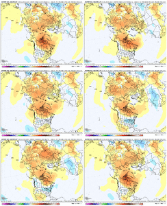
MJO forecasts continue to slow down in P7 now well into the first week of December. That is not going to help with getting a favorable eastern U.S. pattern going.
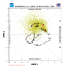
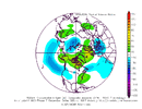
Allan also makes a good point about the lag between an SSWE and resultant impacts - another reason to doubt December is going to come in with a winter pattern already established for us. If the MJO lags in P7 through week 1 of December + SSWE doesn't occur until around early December, we're looking at realistically week 2 or week 3 before an atmospheric response to those impulses would be expected and that is if they even occur at all.
I see a lot of competing factors for early December as it stands now, which leads me to believe early December may not feature a locked-in winter weather regime with a strong west-based -NAO and a downstream eastern U.S. trough and favorable Pacific, but as always, would love to be wrong.
If confidence in the MJO moving into P8 increases, I'll feel a lot better about things, but I remain skeptical of that happening as of now considering the research done showing the present -NAO we have may actually increase potential for the MJO to not move in that direction, but instead work against it.


MJO forecasts continue to slow down in P7 now well into the first week of December. That is not going to help with getting a favorable eastern U.S. pattern going.


Allan also makes a good point about the lag between an SSWE and resultant impacts - another reason to doubt December is going to come in with a winter pattern already established for us. If the MJO lags in P7 through week 1 of December + SSWE doesn't occur until around early December, we're looking at realistically week 2 or week 3 before an atmospheric response to those impulses would be expected and that is if they even occur at all.
I see a lot of competing factors for early December as it stands now, which leads me to believe early December may not feature a locked-in winter weather regime with a strong west-based -NAO and a downstream eastern U.S. trough and favorable Pacific, but as always, would love to be wrong.
If confidence in the MJO moving into P8 increases, I'll feel a lot better about things, but I remain skeptical of that happening as of now considering the research done showing the present -NAO we have may actually increase potential for the MJO to not move in that direction, but instead work against it.
Webberweather53
Meteorologist
My confidence is still low for early December. IMO, unless you are looking for heartache, I wouldn't be putting any stock in the long range ensembles / weeklies. Last 14 run loop for week 1 of December shows how clueless the euro weeklies are.
View attachment 176098View attachment 176099
MJO forecasts continue to slow down in P7 now well into the first week of December. That is not going to help with getting a favorable eastern U.S. pattern going.
View attachment 176100View attachment 176102
Allan also makes a good point about the lag between an SSWE and resultant impacts - another reason to doubt December is going to come in with a winter pattern already established for us. If the MJO lags in P7 through week 1 of December + SSWE doesn't occur until around early December, we're looking at realistically week 2 or week 3 before an atmospheric response to those impulses would be expected and that is if they even occur at all.
I see a lot of competing factors for early December as it stands now, which leads me to believe early December may not feature a locked-in winter weather regime with a strong west-based -NAO and a downstream eastern U.S. trough and favorable Pacific, but as always, would love to be wrong.
If confidence in the MJO moving into P8 increases, I'll feel a lot better about things, but I remain skeptical of that happening as of now considering the research done showing the present -NAO we have may actually increase potential for the MJO to not move in that direction, but instead work against it.
I strongly disagree with this entire take but to each his own.
Euro weeklies, extended GEFS, and CMC weeklies all pretty much have the general same idea wrt the NAO and PNA as we head into early December
View attachment 176093
View attachment 176094
View attachment 176095
The low frequency base state + MJO + Eq Rossby Wave analog also agrees
View attachment 176096
Attachments
Webberweather53
Meteorologist
My confidence is still low for early December. IMO, unless you are looking for heartache, I wouldn't be putting any stock in the long range ensembles / weeklies. Last 14 run loop for week 1 of December shows how clueless the euro weeklies are.
View attachment 176098View attachment 176099
MJO forecasts continue to slow down in P7 now well into the first week of December. That is not going to help with getting a favorable eastern U.S. pattern going.
View attachment 176100View attachment 176102
Allan also makes a good point about the lag between an SSWE and resultant impacts - another reason to doubt December is going to come in with a winter pattern already established for us. If the MJO lags in P7 through week 1 of December + SSWE doesn't occur until around early December, we're looking at realistically week 2 or week 3 before an atmospheric response to those impulses would be expected and that is if they even occur at all.
I see a lot of competing factors for early December as it stands now, which leads me to believe early December may not feature a locked-in winter weather regime with a strong west-based -NAO and a downstream eastern U.S. trough and favorable Pacific, but as always, would love to be wrong.
If confidence in the MJO moving into P8 increases, I'll feel a lot better about things, but I remain skeptical of that happening as of now considering the research done showing the present -NAO we have may actually increase potential for the MJO to not move in that direction, but instead work against it.
There’s a lot of glaring issues and inconsistencies here that need to be pointed out.
For one thing, RMM MJO only explains a third of the subseasonal variance in U200, U850, & OLR, the other 67% of that variability is very important, especially when you’re advancing towards a warm enso state (EOF-3). As Ventrice et al pointed out in their creation of the VPM MJO index over 10 years ago, RMM has a lot of issues tracking the MJO outside the Warm Pool. The index crashing into the null phase doesn’t mean what you think it does
Most models also have a weak and fast bias with the MJO, this is supported by literature and having seen hundreds upon hundreds of mjo forecasts over the decade plus I’ve been doing this. Some people have to learn the hard way about these and that’s fine.
Even still, let’s say hypothetically for some odd reason this doesn’t verify, are those height anomalies on the phase 7 composite even significant? Better yet, are they actually representative of how the current base state will interact with MJO?
The low frequency + MJO constructed analog (which accounts for both), created by Dr Roundy says that’s a hard no.

Dude, you just don't ever know when to stop. You can't even interpret the research papers you cite correctly, but incessantly feel the need to correct others. Stop responding to me. I'm allowed to have my own interpretations and I certainly don't need someone who chatGPT agrees can't even interpret a basic research paper correctly trying to correct me.There’s a lot of glaring issues and inconsistencies here that need to be pointed out.
For one thing, RMM MJO only explains a third of the subseasonal variance in U200, U850, & OLR, the other 67% of that variability is very important, especially when you’re advancing towards a warm enso state (EOF-3). As Ventrice et al pointed out in their creation of the VPM MJO index over 10 years ago, RMM has a lot of issues tracking the MJO outside the Warm Pool. The index crashing into the null phase doesn’t mean what you think it does
Most models also have a weak and fast bias with the MJO, this is supported by literature and having seen hundreds upon hundreds of mjo forecasts over the decade plus I’ve been doing this. Some people have to learn the hard way about these and that’s fine.
Even still, let’s say hypothetically for some odd reason this doesn’t verify, are those height anomalies on the phase 7 composite even significant? Better yet, are they actually representative of how the current base state will interact with MJO?
The low frequency + MJO constructed analog (which accounts for both), created by Dr Roundy says that’s a hard no.
View attachment 176114
Here's a few highlights from chatGPT's assessment of your analysis last night:
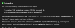
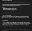
Attachments
Webberweather53
Meteorologist
Dude, you just don't ever know when to stop. You can't even interpret the research papers you cite correctly, but incessantly feel the need to correct others. Stop responding to me. I'm allowed to have my own interpretations and I certainly don't need someone who chatGPT agrees can't even interpret a basic research paper correctly trying to correct me.
Here's a few highlights from chatGPT's assessment of your analysis last night:
View attachment 176117
View attachment 176116
It’s hard to take someone that calls themself a meteorologist seriously that uses chat gpt to give them all the answers
Lol well now it’s pretty obvious you didn’t critically read the paper or are incapable of critically thinking on your own about this topic when you’re chat GPT’ing the cliff notes paper summaries and all of your responses
What's embarrassing is having AI confirm that someone who considers themselves an expert in their field can't interpret a basic research paper accurately. Nice try on the insult, I've got plenty more psychological analysis it has done of you as well if you'd like to read it.It’s hard to take someone that calls themself a meteorologist seriously that uses chat gpt to give them all the answers
Lol well now it’s pretty obvious you didn’t critically read the paper or are incapable of critically thinking on your own about this topic when you’re chat GPT’ing the cliff notes paper summaries and all of your responses
Webberweather53
Meteorologist
You good over there bro? It seems like you forgot to properly copy that last chat gpt answer into this thread
My confidence is still low for early December. IMO, unless you are looking for heartache, I wouldn't be putting any stock in the long range ensembles / weeklies. Last 14 run loop for week 1 of December shows how clueless the euro weeklies are.
View attachment 176098View attachment 176099
MJO forecasts continue to slow down in P7 now well into the first week of December. That is not going to help with getting a favorable eastern U.S. pattern going.
View attachment 176100View attachment 176102
Allan also makes a good point about the lag between an SSWE and resultant impacts - another reason to doubt December is going to come in with a winter pattern already established for us. If the MJO lags in P7 through week 1 of December + SSWE doesn't occur until around early December, we're looking at realistically week 2 or week 3 before an atmospheric response to those impulses would be expected and that is if they even occur at all.
I see a lot of competing factors for early December as it stands now, which leads me to believe early December may not feature a locked-in winter weather regime with a strong west-based -NAO and a downstream eastern U.S. trough and favorable Pacific, but as always, would love to be wrong.
If confidence in the MJO moving into P8 increases, I'll feel a lot better about things, but I remain skeptical of that happening as of now considering the research done showing the present -NAO we have may actually increase potential for the MJO to not move in that direction, but instead work against it.
Looking at the new Euro monthly for Jan vs the prior run, Jan is much colder. I’m guessing that this is due at least partially to the significant % of potential SSWE’s. This SSWE was too far out to be predicted on the prior monthly run. Note that Dec is about the same, which is consistent with the idea that due to lag that Jan wouid be much more affected.
Hit F5 much? You continue to show your mental unstableness. I really do hope you get some help eventually.You good over there bro? It seems like you forgot to properly copy that last chat gpt answer into this thread
P.S. I got your chatGPT analysis for you, don't worry. Just hit F5 again.
Webberweather53
Meteorologist
What's embarrassing is having AI confirm that someone who considers themselves an expert in their field can't interpret a basic research paper accurately. Nice try on the insult, I've got plenty more psychological analysis it has done of you as well if you'd like to read it.
View attachment 176118
Clearly, you just don’t understand how S2S forecasting actually works or simply aren’t intelligent enough come up with your own, well thought out responses and interpretations of this information.
I would highly recommend staying in your lane from now on and leave the S2S forecasts to the real experts
I'll continue to offer my independent thoughts whenever I feel like it and you'll have to learn how to deal with it. Your inability to handle anyone with a morsel of credibility who disagrees with you is tired and pathetic. I'm bored of your act and this will be my final reply to you.Clearly, you just don’t understand how S2S forecasting actually works or simply aren’t intelligent enough come up with your own, well thought out responses and interpretations of this information.
I would highly recommend staying in your lane from now on and leave the S2S forecasts to the real experts
Webberweather53
Meteorologist
I'll continue to offer my independent thoughts whenever I feel like it and you'll have to learn how to deal with it. Your inability to handle anyone with a morsel of credibility who disagrees with you is tired and pathetic. I'm bored of your act and this will be my final reply to you.
Independent? Bud, you used chat gpt to get the cliff notes versions of these papers and basically copied them into this thread and all of my rebuttals
I’m sorry, but I cannot take you seriously
tennessee storm
Member
Or notWebber vs 1300M. This is how you know winter is about to kick off.
Webberweather53
Meteorologist
Worst map I’ve ever seenView attachment 176121
What is this
We haven’t had 4” of snow in a single event since 2015 here. Hard enough to get precip in general over southern NM in winter, but snow is a whole different animal.
I’ll believe it when I see it
Love the Farmers AlamancWorst map I’ve ever seenView attachment 176121

