-
Hello, please take a minute to check out our awesome content, contributed by the wonderful members of our community. We hope you'll add your own thoughts and opinions by making a free account!
You are using an out of date browser. It may not display this or other websites correctly.
You should upgrade or use an alternative browser.
You should upgrade or use an alternative browser.
Tropical Major Hurricane Erin
- Thread starter SD
- Start date
Shaggy
Member
At one point I remember seeing option to view the 5-day cone and track forecast in animation to show the changes and how it progressed does anybody know where to find that?
Brent
Member
At one point I remember seeing option to view the 5-day cone and track forecast in animation to show the changes and how it progressed does anybody know where to find that?
Should work if not click the storm archive then graphics archive next to the advisory
western pacific looking storm lol
Stormsfury
Member
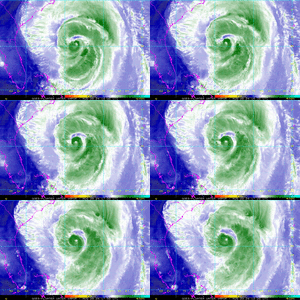
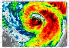
Eye reappearing on IR again. She's trying
Downeastnc
Member
Eye reappearing on IR again. She's trying
It's like a microcane forming at the center of a hurricane with a 100 mile wide eye...
Downeastnc
Member
Not getting those down to the surface though...very Isabel like. When she came ashore we got into the SW eyewall with 100knt plus winds overhead and only gusted to 50ish at the surface.
So far on this current recon there has not been any SFMR over 80ish knts...though the area that is seeing those winds at the surface is pretty huge.
Hurricane Erin Intermediate Advisory Number 37A
NWS National Hurricane Center Miami FL AL052025
200 PM EDT Wed Aug 20 2025
SUMMARY OF 200 PM EDT...1800 UTC...INFORMATION
----------------------------------------------
LOCATION...30.6N 73.6W
ABOUT 530 MI...855 KM W OF BERMUDA
ABOUT 335 MI...540 KM SSE OF CAPE HATTERAS NORTH CAROLINA
MAXIMUM SUSTAINED WINDS...110 MPH...175 KM/H
PRESENT MOVEMENT...N OR 360 DEGREES AT 13 MPH...20 KM/H
MINIMUM CENTRAL PRESSURE...943 MB...27.85 INCHES
Some strengthening is expected during the next day or so,
and Erin could become a major hurricane again by tonight. Weakening
is likely to begin by Friday, but Erin is forecast to remain a
hurricane into the weekend.
Erin is a large hurricane. Hurricane-force winds extend outward up
to 105 miles (165 km) from the center and tropical-storm-force
winds extend outward up to 265 miles (425 km).
Looks pretty sick not gonna lie
Henry2326
Member
And there you have it folks.....the most resilient hurricane in the most recent past. 

 Thrilled she is not moving inland.
I may be wrong but with that eye, guessing she is way past 110 mph.
NHC 11am
INIT 20/1500Z 30.1N 73.7W 95 KT 110 MPH
12H 21/0000Z 32.0N 73.6W 105 KT 120 MPH
24H 21/1200Z 34.4N 72.2W 105 KT 120 MPH
36H 22/0000Z 36.6N 69.4W 100 KT 115 MPH
48H 22/1200Z 38.6N 65.5W 90 KT 105 MPH
60H 23/0000Z 40.4N 60.5W 80 KT 90 MPH
72H 23/1200Z 42.5N 54.3W 65 KT 75 MPH
96H 24/1200Z 47.4N 40.0W 55 KT 65 MPH...POST-TROP/EXTRATROP
120H 25/1200Z 52.5N 27.4W 50 KT 60 MPH...POST-TROP/EXTRATROP

Last edited:
Shaggy
Member
I'm heading back over to Wrightsville Beach to try to get a few more videos today to see how much bigger the waves are
South End, @ Old Crystal Pier, It's loaded w/surfers.I'm heading back over to Wrightsville Beach to try to get a few more videos today to see how much bigger the waves are
Wrightsville Beach – Surfchex
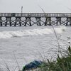
IF you watch the Surf City pier "T", aka on the end,, It's Rockin & Rollin...
Watch that HUGE 8 X 8 on the end.. (Shaking)..
 www.surfchex.com
Watch that HUGE 8 X 8 on the end.. (Shaking)..
Surf City Fishing Pier “T” – Surfchex
Man that ain’t no little stormGot some dry air lurking north of the CoC. But eyewall looking good.
View attachment 174452
Size Matters!Man that ain’t no little storm
Shaggy
Member
Beaches are going to wash away down to the bedrock
Shaggy
Member
First storm to ever cause wavesBeaches are going to wash away down to the bedrock
There are entirely families out playing in the water here. Fire dept is sitting at public accesses waiting, kind of crazy to seeNow for my not so nice post. I had my son on a giant concrete pier to view the Waves. There was a family that had their 2 daughters IN THE WATER both under the age of 10. That is insane and should lead to a CPS visit. WTF is wrong with people!!!!View attachment 174461
Shaggy
Member
I mean it's just insane the fact that Aaron may take lives and never come within 200 miles of the coastline because people are too stupid to not go in the waterThere are entirely families out playing in the water here. Fire dept is sitting at public accesses waiting, kind of crazy to see
Oregon inlet about to widen. Pea Island might get a smidge smaller. It’s all just a giant sandbar anyway. Not so shocking when looking at it objectively.
That low area just north of Rodanthe will breach one day and you’ll have another inlet there. Probably in your grandkids lifetime
Shaggy
Member
Brent
Member
For all the talk about west and the models are wrong its actually east
Go figure
Go figure
NoSnowATL
Member
It always was going to stay OTS. But wishcasting is like a drug.For all the talk about west and the models are wrong its actually east
Go figure
Shaggy
Member
If you watch the animation of track it was way west early but the exit was always gonna be in place. The curve just kept sharpening up.For all the talk about west and the models are wrong its actually east
Go figure
For all the talk about west and the models are wrong its actually east
Go figure
To be fair though, the NHC/model consensus were significantly too far east as recently as 96 hours out. For example, this is from the 11PM Fri 8/15 NHC discussion:
FORECAST POSITIONS AND MAX WINDS
INIT 16/0300Z 19.5N 59.5W 85 KT 100 MPH
12H 16/1200Z 20.2N 61.6W 100 KT 115 MPH
24H 17/0000Z 20.9N 64.2W 115 KT 130 MPH
36H 17/1200Z 21.7N 66.3W 125 KT 145 MPH
48H 18/0000Z 22.9N 67.9W 120 KT 140 MPH
60H 18/1200Z 24.0N 68.9W 115 KT 130 MPH
72H 19/0000Z 25.6N 69.8W 110 KT 125 MPH
96H 20/0000Z 28.9N 70.5W 105 KT 120 MPH
120H 21/0000Z 33.5N 69.0W 100 KT 115 MPH
Link:
Hurricane ERIN
www.nhc.noaa.gov
Erin ended up going 180 miles west of 70.5W as it went to 73.7W! So, the center ended up ~half the distance from the OBs vs what was originally forecasted.
Last edited:
Related to Erin’s center ending up about half the distance that was forecasted early last weekend, the Outer Banks had sustained TS force winds last night through 8AM despite the center being 200 miles to the SE/ESE/E. Had the earlier forecasts verified, this wouldn’t have occurred:
1. From 2AM NHC advisory:
“A sustained wind of 40 mph (65 km/h) and a gust to 46 mph (74 km/h) were recently reported at the U.S. Coast Guard Station Hatteras.”
2. From 5AM NHC advisory:
“A WeatherFlow station at
Jennette's Pier in Nags Head, North Carolina, recently measured a sustained wind of 41 mph (67 km/h) and a gust to 49 mph (80 km/h).”
3. From 8AM NHC advisory:
“A WeatherFlow station at Jennette's Pier in Nags Head, North Carolina, recently measured a sustained wind of 45 mph (72 km/h) and a gust to 54 mph (87 km/h).”
never a doubt, easy forecast, though the west nudges did have me at attention at one point. had to stay disciplinedIt always was going to stay OTS. But wishcasting is like a drug.
this is funny and totally something i would post but the surfers in my life are calling this generationalFirst storm to ever cause waves
You out there in your speedos, pal?
NCHighCountryWX
Member
- Joined
- Dec 28, 2016
- Messages
- 653
- Reaction score
- 1,828
Anyone have the highest recorded wind gust on the outer banks? On the ECONET on top of Jockey's ridge there was just one gust to 34 mph
Ignore.. i see GeorgiaWX earlier post now
 econet.climate.ncsu.edu
Ignore.. i see GeorgiaWX earlier post now
Environment & Climate Observing Network
Southernwx branded with @SD on the leg so everyone knows it's meYou out there in your speedos, pal?

