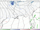
Mesoscale discussion out for heavy rainfall.....
Mesoscale Precipitation Discussion 1222
NWS Weather Prediction Center College Park MD
656 AM EST Tue Dec 26 2023
Areas affected...portions of the Southern Appalachians & Piedmont
Concerning...Heavy rainfall...Flash flooding possible
Valid 261156Z - 261756Z
Summary...Showers and thunderstorms with heavy rain are expected
to continue through the morning. Hourly rain totals to 2" with
local amounts to 4" are possible.
Discussion...Surface observations indicate that a coastal
front/thermal boundary has progressed into the Piedmont of the
southern Appalachians due to surface southeast flow to the
northeast of a surface low in GA. Precipitable water values of
~1.25" lie in the area. MU CAPE of 250-500 J/kg lie to the
southwest, and are being advected into the region by southwest
winds within the cyclone's warm sector at 10-15 kts at 850 hPa per
VAD wind profiles. There is some evidence for 850 hPa
frontogenesis near the convective activity which is moving
north-northeast along the lines of the mean 850-400 hPa wind.
This above has led to a bit of precipitation efficiency, with
radar estimates exceeding 1.5" totals in an hour at times.
Instability trends are very slowly declining, which fits in with
06z HREF expectations for a slow drop off in hourly rain totals
with time. Still, there is enough of a signal, and for the time
being enough instability for 3" totals within convection that
forms near and poleward of the coastal front, particularly in the
very short term, to be concerned about flash flooding within area
terrain despite recent dryness as they would exceed the 3 hourly
flash flood guidance in the area. Until instability declines,
hourly rain totals to 2" and local amounts to 4" would remain
possible.
Roth