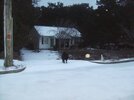
My educated guess is that this (8-10") is a top 10 snow storm and quite possibly top 5 for Marietta and much of the NW burbs of ATL going back to 1879 based strictly on total accumulation. Those locations got over 3 winters' worth of snow! From center city ATL eastward to Decatur and a bit east of there, where near 4" appears to be a reasonable estimate (my sis got ~5" but she's a little north of this strip), I'm thinking top 25 and possibly top 20 for storms dominated there by snow. Now, the airport got 3.1". Had the airport been there back to 1879, my guess would be that's top 30-35 for snow dominated storms in that location.
-
Hello, please take a minute to check out our awesome content, contributed by the wonderful members of our community. We hope you'll add your own thoughts and opinions by making a free account!
You are using an out of date browser. It may not display this or other websites correctly.
You should upgrade or use an alternative browser.
You should upgrade or use an alternative browser.
A few returns popping up on FFC radar in west ga..wonder if anything is falling? Overcast here again and 30.
ForsythSnow
Moderator
This storm ranks on top of the 2011 storm for me, and was the best one I have ever seen, which means it likely won't be topped soon unless we get something extreme in the next month or so. I expect there to be some snow all the way through the end of the week in shaded areas.My educated guess is that this (8-10") is a top 10 snow storm and quite possibly top 5 for Marietta and much of the NW burbs of ATL going back to 1879 based strictly on total accumulation. Those locations got over 3 winters' worth of snow! From center city ATL eastward to Decatur and a bit east of there, where near 4" appears to be a reasonable estimate (my sis got ~5" but she's a little north of this strip), I'm thinking top 25 and possibly top 20 for storms dominated there by snow. Now, the airport got 3.1". Had the airport been there back to 1879, my guess would be that's top 30-35 for snow dominated storms in that location.
This storm ranks on top of the 2011 storm for me, and was the best one I have ever seen, which means it likely won't be topped soon unless we get something extreme in the next month or so. I expect there to be some snow all the way through the end of the week in shaded areas.
My educated guess is that for Forsyth County overall that this was at least a top 15 of all-time (back to 1879) and quite possibly top 10 strictly in terms of accumulation of snow
Same thing on the TWC app.A few returns popping up on FFC radar in west ga..wonder if anything is falling? Overcast here again and 30.
Webberweather53
Meteorologist
As crazy as this storm was, could you only imagine if those totals just north of Atlanta were realized across as large of an expanse of the southeastern US as we saw in January 1940... More than two-thirds of Mississippi had 6"+ of snow for example...

Snow_chaser
Member
Just hit 22 hours without power and it’s 46 in the House. Loaded up family and headed to my parents place.
Hate it, we didn't have power thru night and most if day but afternoon or came back stay warmJust hit 22 hours without power and it’s 46 in the House. Loaded up family and headed to my parents place.
Snow_chaser
Member
Thanks, power company app says we have power even tho we reported it out. Only like 3 streets in subdivision still in dark, rest have powerHate it, we didn't have power thru night and most if day but afternoon or came back stay warm
Blue_Ridge_Escarpment
Member
Snow starting again here. Already an additional half inch. These bands coming out of East Tennessee mean business
It will probably be at least 20 years or so before we can top this one.This storm ranks on top of the 2011 storm for me, and was the best one I have ever seen, which means it likely won't be topped soon unless we get something extreme in the next month or so. I expect there to be some snow all the way through the end of the week in shaded areas.
WeatherWatch
Member
Wow, Mountain City, GA got 18" of snow!
WeatherWatch
Member
It makes you wonder!Call me crazy, but this could a preview of what to come this winter.:weenie:
Ron Burgundy
Member
Wow, Mountain City, GA got 18" of snow!
And, strangely, Clayton (three miles south) reported at 6.6”.

It will probably be at least 20 years or so before we can top this one.
I'm educatedly guessing that Carrolton/you with about 8" got a top 5 snow accum going back to 1879! You picked the right winter to move back there!
Congrats to the biggest of big winners like Forsyth, MBell, arcc, and yourself (I'm sure I left off other huge winners) who got like 8-11"! Also congrats to the many still big winners like accu, Storm5, as well as others in Birm and ATL area and in between that didn't quite get into that category but still got a big, beautiful, and very long duration snow! Congrats to those who got much less but still got rare snow like in FL Panhandle! Those that missed will get theirs another time. This was amazing to follow.
Walking to the field I was still trudging through 4-6" snow with some deeper pockets.
Still dark here. I imagine knowing how our power feeds, it will likely be another day or so before it is back on.
Still dark here. I imagine knowing how our power feeds, it will likely be another day or so before it is back on.
We definitely made up for the horrible Decembers we have had since 2011 !
In a normal year a 1-2" snow event would be something I would get excited about, but after this storm im not sure i will get as excited if we have a 1-2" snow later in the winter. Any snow we may have will pale in comparison to this one.
Ohh you know is as much about the chase as it is the totalsIn a normal year a 1-2" snow event would be something I would get excited about, but after this storm im not sure i will get as excited if we have a 1-2" snow later in the winter. Any snow we may have will pale in comparison to this one.
Webberweather53
Meteorologist
A snowstorm of this magnitude & spatial extent in early December in the deep south likely hasn't occurred in at least 131 years. In early December 1886, a broad area of low pressure and attendant upper level trough dropped more than 6-12 inches of snow parts of Mississippi, Alabama, Georgia, Tennessee, and North Carolina with accumulating snows occurring as far south as the Florida panhandle. Of course, ironically 1886-87 was a La Nina winter which came in the wake of a multi-year warm ENSO event that lasted from 1884 to 1886 (although there's some argument that it could have already been prevalent as early as 1883).
Here's a few snowfall totals from available stations in the southeast. I'm sure the totals in places like Atlanta, Birmingham, & Huntsville (where little-no data currently exists) were incredible, likely about 1-2 feet or so...
December 4-6 1886
Knoxville, TN: 22.6"
Chatanooga, TN: 14.9”
Montgomery, AL: 11.0”
Kingston, TN: 10.0”
Charlotte, NC: 7.2”
Nashville, TN: 2.4”
Penscola, FL: 0.5"
Augusta, GA: T
Wilmington, NC: T


The daily weather data that I took a screenshot of above is available here, just find your local NWS office.
http://sercc.com/nowdata.html
Here's a few snowfall totals from available stations in the southeast. I'm sure the totals in places like Atlanta, Birmingham, & Huntsville (where little-no data currently exists) were incredible, likely about 1-2 feet or so...
December 4-6 1886
Knoxville, TN: 22.6"
Chatanooga, TN: 14.9”
Montgomery, AL: 11.0”
Kingston, TN: 10.0”
Charlotte, NC: 7.2”
Nashville, TN: 2.4”
Penscola, FL: 0.5"
Augusta, GA: T
Wilmington, NC: T
The daily weather data that I took a screenshot of above is available here, just find your local NWS office.
http://sercc.com/nowdata.html
bud006
Member
I'm educatedly guessing that Carrolton/you with about 8" got a top 5 snow accum going back to 1879! You picked the right winter to move back there!
Congrats to the biggest of big winners like Forsyth, MBell, arcc, and yourself (I'm sure I left off other huge winners) who got like 8-11"! Also congrats to the many still big winners like accu, Storm5, as well as others in Birm and ATL area and in between that didn't quite get into that category but still got a big, beautiful, and very long duration snow! Congrats to those who got much less but still got rare snow like in FL Panhandle! Those that missed will get theirs another time. This was amazing to follow.
8” in NE Forsyth Cty. Just an amazing storm to watch unfold, all across the south!
Sent from my iPhone using Tapatalk
Looking back, two things.
The 0z CMC run on Tuesday night nailed it.
I had forgotten how fast things changed. It went from very little precip over southern AL to a central AL crushing in under two days. Has the models ever blown it that much that close in the recent ten years. In 2014 they just missed on precip placement, hereally they whiffed on a lot more.
Showmeyourtds
Member
Looking back, two things.
The 0z CMC run on Tuesday night nailed it.
I had forgotten how fast things changed. It went from very little precip over southern AL to a central AL crushing in under two days. Has the models ever blown it that much that close in the recent ten years. In 2014 they just missed on precip placement, hereally they whiffed on a lot more.
Synoptically, 2014 was modeled well, but the mesoscale features were the things that the models didn’t catch on to...it was the short rangers that nailed it in particular.
Blue_Ridge_Escarpment
Member
The Euro really crapped the bed with this storm for sure. Even in its wheelhouse timeframe. I think we can put to rest that it is still the king. #dethroned.
There hasnt been this many power outages in this area since Opal in 1995. Some people have been out of power 2 days.
ForsythSnow
Moderator
The CMC did great. It gave us here in GA high totals before anyone else did. Personally, I believe this was the CMC's year of rising, given its performance in the tropics for some of the year being better than ever, and it getting this storm correct.Looking back, two things.
The 0z CMC run on Tuesday night nailed it.
I had forgotten how fast things changed. It went from very little precip over southern AL to a central AL crushing in under two days. Has the models ever blown it that much that close in the recent ten years. In 2014 they just missed on precip placement, hereally they whiffed on a lot more.
WeatherWatch
Member
Meteorologist Mike says the 3km NAM performed great.
This is from Friday afternoon
W
WeatherLC
Guest
You forgot meI'm educatedly guessing that Carrolton/you with about 8" got a top 5 snow accum going back to 1879! You picked the right winter to move back there!
Congrats to the biggest of big winners like Forsyth, MBell, arcc, and yourself (I'm sure I left off other huge winners) who got like 8-11"! Also congrats to the many still big winners like accu, Storm5, as well as others in Birm and ATL area and in between that didn't quite get into that category but still got a big, beautiful, and very long duration snow! Congrats to those who got much less but still got rare snow like in FL Panhandle! Those that missed will get theirs another time. This was amazing to follow.
W
WeatherLC
Guest
Doesn't surprise me. The way the bands set up created massive winners and losers justAnd, strangely, Clayton (three miles south) reported at 6.6”.
Miles apart.
You forgot me
Yep, and several others in Forsyth County of the regular posters and likely several other regular posters as well. But the biggest winner I left off may have been Rosie who got an entire foot!! Then again, I'd much rather be left off of a congratulations list than be left out of a big snow.
Still have a good 5-6” this evening. Most roofs are still covered as well. Insane!
Sent from my iPhone using Tapatalk
Sent from my iPhone using Tapatalk
Man talk about a tale of two neighborhoods. Most of the snow is completely gone across the street from me, but most of the snow on my side of the street is still on the ground. I think I still have about 2-3 inches out of the 5 on the grass/bushes. lol
Power is back and part of the limb has bewn cut off the heat pump. It will be this weekend before I can cut those limb's and see if my roof is damaged.
Taylor C
Member
The overnight snow was a good amount for me. I went to bed with 5 inches, and woke up with 7. The amount of tree damage from the weight of the snow was very impressive.
Cut the limbs off the roof today. Thankfully just a little damage on the eave. Now I have to figure out how to get the limb off my shop with damaging it.
accu35
Member
Is your shop tin roof?Cut the limbs off the roof today. Thankfully just a little damage on the eave. Now I have to figure out how to get the limb off my shop with damaging it.
Is your shop tin roof?
I don't have the tin up yet. Right now I need to get the limb down out of the tree which is still hanging. It has already broken two rafters, so getting it down without breaking any more will be a task.
So much for that. Two more rafters snapped, buy the large limb is on the ground waiting to be chopped for firewood. Got the yard cleaned of most of the branches. Crazy that a snowstorm did more damage than all the thunderstorms and the two tropical storms of the past two and a half years combined.