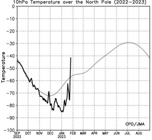
Really? Are we sure. Been a lot of talkSSW Happening
-
Hello, please take a minute to check out our awesome content, contributed by the wonderful members of our community. We hope you'll add your own thoughts and opinions by making a free account!
You are using an out of date browser. It may not display this or other websites correctly.
You should upgrade or use an alternative browser.
You should upgrade or use an alternative browser.
Pattern Fail or Fab February 2023 Pattern Thread
- Thread starter RBR71
- Start date
Webberweather53
Meteorologist
SSW Happening
No it’s not
Need the zonal winds to reverse for this to classify as a SSW and it’s not even close here (notice the graph doesn’t even extend below 0 ms-1.) In fact, the polar vortex will immediately recover largely to where it was before in a few days, thanks in large part to the raging +NAO and no Scandinavian blocking in the troposphere. The only effect a minor warming event like this could be having is making the MJO even stronger in the warm phases during the coming weeks

LukeBarrette
im north of 90% of people on here so yeah
Meteorology Student
Member
2024 Supporter
2017-2023 Supporter


That seems like an improvement atm
The s/w out west is much stronger with far more separation so far.

LukeBarrette
im north of 90% of people on here so yeah
Meteorology Student
Member
2024 Supporter
2017-2023 Supporter
Yeah was about to say that’s probably not good, gonna bring up too much warmthThe s/w out west is much stronger with far more separation so far.
LukeBarrette
im north of 90% of people on here so yeah
Meteorology Student
Member
2024 Supporter
2017-2023 Supporter

Perfectly sums up this winter
Well, we slowed down the southern energy, but got no cooporation from the northern stream to build a daming HP in time.

Hello

Webberweather53
Meteorologist
You need the southern stream wave over GA + northern FL to be roughly over Texas at this time step to allow the cold air and surface high time to get in front of the overrunning precipitation and have a real chance to score snow/ice.

Need the GFs HP and the Canadian Low for next Saturday, like originally timed and we be in business
Get some sleet northern NC , so not as much frzng rain

Big flip last week of Feb CFS. Goes deep freeze mode.

Webberweather53
Meteorologist
Not surprising to me, but the subx multi model mean has an 80-90% chance of a ridge over the SE US for the bulk of February


J1C1111
Member
I see nothing different down the road in February as what I just experienced in January. Only my 6th January since 81-82 in my 40 years of living around here in the Forest City area with no frozen precip recorded in January. How much less snow or snow chances can you get in February when have got the big goose egg so far in January in the frozen department. Nothing at all. I see the temperature pattern in February the same as January, a few cold days highs in the 40's and more than a few colder nights in the 20's maybe mid to low 20's mixed in then moderation back to highs in the 50s and maybe a few 60's at times. Maybe a few. First 10 days of February around here are looking slightly below average to average. I'm betting the farm in February if you want winter weather it can't be any worse than than what this winter has been so far. Just a continuation of cold rain wedge here east of the mountains as usual with highs in the 30's and 40's for a couple days. Rain stops, a dry day or two and we have some days with highs 40s with lows back in the 20's at night and then we warmup just enough and do some more cold rain all over again and then again. I just don't see the difference in your prior post about about when you said well if you think January has been bad for winter weather just wait till February it will be worse. No offense at all but I just don't see the difference through the first 10 days of February or after for that matter. Looks like the same kind of January continuation pattern to me.Not surprising to me, but the subx multi model mean has an 80-90% chance of a ridge over the SE US for the bulk of February
View attachment 131574
ATLwxfan
Member
Not surprising to me, but the subx multi model mean has an 80-90% chance of a ridge over the SE US for the bulk of February
View attachment 131574
Would be cool to see NYC go without measurable snow the whole year. They probably find a way to score in March though.
Sent from my iPhone using Tapatalk
Webberweather53
Meteorologist
I see nothing different down the road in February as what I just experienced in January. Only my 6th January since 81-82 in my 40 years of living around here in the Forest City area with no frozen precip recorded in January. How much less snow or snow chances can you get in February when have got the big goose egg so far in January in the frozen department. Nothing at all. I see the temperature pattern in February the same as January, a few cold days highs in the 40's and more than a few colder nights in the 20's maybe mid to low 20's mixed in then moderation back to highs in the 50s and maybe a few 60's at times. Maybe a few. First 10 days of February around here are looking slightly below average to average. I'm betting the farm in February if you want winter weather it can't be any worse than than what this winter has been so far. Just a continuation of cold rain wedge here east of the mountains as usual with highs in the 30's and 40's for a couple days. Rain stops, a dry day or two and we have some days with highs 40s with lows back in the 20's at night and then we warmup just enough and do some more cold rain all over again and then again. I just don't see the difference in your prior post about about when you said well if you think January has been bad for winter weather just wait till February it will be worse. No offense at all but I just don't see the difference through the first 10 days of February or after for that matter. Looks like the same kind of January continuation pattern to me.
This whole response is wishcasting. Mid February is almost certainly going to be warmer than what we've seen the last few weeks, both in a mean and anomaly sense.

ATLwxfan
Member
Lol. CFS just throwing darts.
Sent from my iPhone using Tapatalk
Webberweather53
Meteorologist
If I had a dollar for every one of the "well January really hasn't been THAT warm" posts I've seen on here lately.
No getting around the fact that 70-75% of the month has been above average, with several days in the 60s and even the 70s.
Yes, we've had cold days and nights, but the warm days have been extra warm, the cold days just seasonably cool, and the warm days far out number the amount of colder ones.
Just using Raleigh as an example, which has an average temperature departure of +7.3°F.
As mild as January has been, I doubt February will be an improvement.
Webberweather53
Meteorologist
If I had a dollar for every one of the "well January really hasn't been THAT warm" posts I've seen on here lately.
No getting around the fact that 70-75% of the month has been above average, with several days in the 60s and even the 70s.
Yes, we've had cold days and nights, but the warm days have been extra warm, the cold days just seasonably cool, and the warm days far out number the amount of colder ones.
Just using Raleigh as an example, which has an average temperature departure of +7.3°F.
As mild as January has been, I doubt February will be an improvement.
View attachment 131577
It's also the 9th warmest January on record at RDU since 1887 and the warmest January in nearly 35 years.
J1C1111
Member
You can call it wishcasting all you want. That's fine. You never said mid February in your prior posts about February being warmer. You said about the whole month of February was going to be warmer than avg until maybe the pattern will start to break down the last week of February or the 1st week of March and maybe become favorable for winter storms then. You said we would torch once we entered February and that's not going to happen in the first 10 or so days. How can you call it wishcasting when we have been experiencing this crap weather pattern since winter started and it continues. I would sure put my money on more of the same down the road. Will see what mid February holds.This whole response is wishcasting. Mid February is almost certainly going to be warmer than what we've seen the last few weeks, both in a mean and anomaly sense.
View attachment 131576
J1C1111
Member
Currently 22 this morning.
Webberweather53
Meteorologist
You can call it wishcasting all you want. That's fine. You never said mid February in your prior posts about February being warmer. You said about the whole month of February was going to be warmer than avg until maybe the pattern will start to break down the last week of February or the 1st week of March and maybe become favorable for winter storms then. You said we would torch once we entered February and that's not going to happen in the first 10 or so days. How can you call it wishcasting when we have been experiencing this crap weather pattern since winter started and it continues. I would sure put my money on more of the same down the road. Will see what mid February holds.
Yeah I did, I've said it a lot actually. Let me jog your memory.
This one from January 16th looks like it's going to verify quite nicely overall & is one where I made it very clear how I thought the pattern would progress
https://southernwx.com/community/threads/jammin-january-2023.1159/post-619644
"The big -EAMT event we saw this past week set this pattern evolution into motion and the Pacific jet retraction will get handed off & further reinforced by the MJO as we enter February, leading to a prolonged period of -PNA/SE ridge pattern in the first half-2/3rds of February.
Thus, I think we'll probably go from this central-western weighted trough & southern Canada vortex late month w/ occasional bouts of cold + an outside chance of a CAD event, to a more traditional -PNA in the first week of February that probably shuts down any real chance we have wintry weather, unless we see the 50-50 low go completely crazy like a few EPS & GEFS runs have hinted at.
Thereafter, as we get into the 2nd week of February, I suspect the SE US ridge will actually amplify + flex up the East Coast as the -PNA retreats further into western Canada, yielding a potentially very/unusually mild pattern for much of the E US (not just the SE US this time). I think this pattern will try to persist into at least the 3rd week of February (Feb 14-21), even as the MJO (or whatever comes of subseasonal tropical forcing) enters the West Pacific but by then, I believe we'll see the large-scale puzzle pieces begin to start shuffle around, eventually yielding a potential +EAMT &/or MJO-induced Pacific jet extension sometime around Feb 20th or so.
Eventually, I think that coupled with rapidly shortening jet wavelengths will cause a lot of reshuffling of the circulation pattern over the N Pacific + N America, allowing us to shake off this -PNA/SE ridge pattern sometime around the last week of February & transition to a favorable look for cold/snow right at the tail end of February &/or early March, a time of the winter where we tend to see the most big dog winter storms per capita."
A transient cold shot at the beginning of the month (which mind you has trended warmer) followed by a prolonged period of warmth, growing warmer as we approach mid February doesn't really change the fact that it's going to be unusually mild in February or isn't any different from what I've been saying for weeks.
Neither is the fact that we're getting a traditional -PNA/SE ridge La Nina pattern overall in the first week of February as I also said would happen.


Greensboro will end up like +5.8 to +6.2 territory. Far cry from the -3 December.
Knowing the average temps start creeping up in February and a possible hail mary flip the last week along with a few Below normal days first week. If Gboro has a + 6, RDU a +7 for January. Im gonna say February will end up Above normal, but not as much as January both locations. Ill bet the under.
We should net several 55- 60 degree days, Im sure they will occur during the work week and we cad on weekends lol. Hoping the pacific Guru Web sixth sense of a spring flip happens before March 1st, so maybe we can pull a rabbit out and avoid the shutout. Ive never had one. Saw a 5 to 10 minute snow shower this winter outside of frost, thats been it.
iGRXY
Member
Greensboro probably gets saved by a ton of CAD days. Which is one reason why I don’t pay attention to temp anomalies like that. I’ve had a grand total of 2 60 degree days here in January and it was literally “60 degrees” it has been numerous CAD filled days where we stay between 37-42 constantly. Below average highs but you’re running 5-10 “above average” technically because of the lows. If you look at this all those +5 to +10 temp anomalies you’d think it was spring the whole month when in reality it’s just been 40 degrees and raining the whole monthGreensboro will end up like +5.8 to +6.2 territory. Far cry from the -3 December.
Knowing the average temps start creeping up in February and a possible hail mary flip the last week along with a few Below normal days first week. If Gboro has a + 6, RDU a +7 for January. Im gonna say February will end up Above normal, but not as much as January both locations. Ill bet the under.
We should net several 55- 60 degree days, Im sure they will occur during the work week and we cad on weekends lol. Hoping the pacific Guru Web sixth sense of a spring flip happens before March 1st, so maybe we can pull a rabbit out and avoid the shutout. Ive never had one. Saw a 5 to 10 minute snow shower this winter outside of frost, thats been it.
Good ole Joe Bastardi said in October cold December, torch Jan, and cold comes back late Feb until April. So far he has been right. So the warmth was on the table all along from some forecasts as well as models. Problem is most watch every model run and switch their forecast at most runs. Just like this week the excitement of the gfs which is never right and then euro follows with storm 9 days away which never works out either. The wish casting started.You can call it wishcasting all you want. That's fine. You never said mid February in your prior posts about February being warmer. You said about the whole month of February was going to be warmer than avg until maybe the pattern will start to break down the last week of February or the 1st week of March and maybe become favorable for winter storms then. You said we would torch once we entered February and that's not going to happen in the first 10 or so days. How can you call it wishcasting when we have been experiencing this crap weather pattern since winter started and it continues. I would sure put my money on more of the same down the road. Will see what mid February holds.
I do not get on here and post back and forth but will say Webb has been primarily warm on February as most models have shown that for a while. Nobody likes to hear that. Facts are facts.
This is just not a good winter and never was forecast to be. JB showed in October in his winter outlook the SE did not look good. If cold comes back to se we will be lucky to get anything unless in February. Nobody likes JB but he is one of the best of recognition of patterns.
Also yes we have had big snows in March but its been a while. Have even had snow on April 1st not to long ago but thats a stretch.
BHS1975
Member
The high overnight lows have been driving the anomalies for many years now.
Sent from my iPhone using Tapatalk
Sent from my iPhone using Tapatalk
Webberweather53
Meteorologist
The high overnight lows have been driving the anomalies for many years now.
Sent from my iPhone using Tapatalk
The afternoon highs have actually been driving this month's warmth more so than the lows.
BHS1975
Member
The afternoon highs have actually been driving this month's warmth more so than the lows.
Yeah in general the loss of heat from radiation is less effective now especially near the east coast with higher dew points.
Sent from my iPhone using Tapatalk
NBAcentel
Member
From what I can see on WU and wither nearby stations the average there is around 60/61 for a high and 33/34 for lows, so highs is driving the above normal temps, and many stations around you (including this one) have more in the range of 4-7 60 degree days, some have 1-2 70s (this one has 70), it might not seem like it but there’s been plenty of 60sGreensboro probably gets saved by a ton of CAD days. Which is one reason why I don’t pay attention to temp anomalies like that. I’ve had a grand total of 2 60 degree days here in January and it was literally “60 degrees” it has been numerous CAD filled days where we stay between 37-42 constantly. Below average highs but you’re running 5-10 “above average” technically because of the lows. If you look at this all those +5 to +10 temp anomalies you’d think it was spring the whole month when in reality it’s just been 40 degrees and raining the whole month


BHS1975
Member
From what I can see on WU and wither nearby stations the average there is around 60/61 for a high and 33/34 for lows, so highs is driving the above normal temps, and many stations around you (including this one) have more in the range of 4-7 60 degree days, some have 1-2 70s (this one has 70), it might not seem like it but there’s been plenty of 60s View attachment 131585View attachment 131586View attachment 131587
Felt more like a normal November that's for sure.
Sent from my iPhone using Tapatalk
J1C1111
Member
I agree with your post. Your right. We still have a shot down the road for snow. I don't try to post back and forth either but when someone acts like you were born yesterday you kinda got to stand your ground a little. My whole point of the post was just saying February can't be any worse than January has been when you have no snow chances or anything in the frozen department. How can February be worse when you have gotten nothing in January. Zero. But im just wishcasting when I comment. Thanks man. I appreciate it.Good ole Joe Bastardi said in October cold December, torch Jan, and cold comes back late Feb until April. So far he has been right. So the warmth was on the table all along from some forecasts as well as models. Problem is most watch every model run and switch their forecast at most runs. Just like this week the excitement of the gfs which is never right and then euro follows with storm 9 days away which never works out either. The wish casting started.
I do not get on here and post back and forth but will say Webb has been primarily warm on February as most models have shown that for a while. Nobody likes to hear that. Facts are facts.
This is just not a good winter and never was forecast to be. JB showed in October in his winter outlook the SE did not look good. If cold comes back to se we will be lucky to get anything unless in February. Nobody likes JB but he is one of the best of recognition of patterns.
Also yes we have had big snows in March but its been a while. Have even had snow on April 1st not to long ago but thats a stretch.
Webberweather53
Meteorologist
I agree with your post. Your right. We still have a shot down the road for snow. I don't try to post back and forth either but when someone acts like you were born yesterday you kinda got to stand your ground a little. My whole point of the post was just saying February can't be any worse than January has been when you have no snow chances or anything in the frozen department. How can February be worse when you have gotten nothing in January. Zero. But im just wishcasting when I comment. Thanks man. I appreciate it.
Winter isn't only about snow, both cold temperatures and snow matter. Not to mention, your first reply to me wasn't only about snow.
Temperature wise, February is most likely going to be worse than January. Enjoy the transient cold shot early in the month, because you probably won't be seeing that kind of cold on a consistent basis for a while to come.
Nomanslandva
Member
I have not completely given up hope on next week into the weekend. The EPS last night had quite a few interesting members in the next 10 days. It was an improvement over yesterday's 12z so ??
January Departure from Mean maps for both High Temperatures (1st image) and Low Temperatures (2nd image)


Webberweather53
Meteorologist
Observed average maximum and minimum month-to-date temperatures via Climate perspectives from the Southeastern Regional Climate Center (SERCC).
Maximum temperatures are majority driving the temperature anomalies in the SE US (noticeably greater coverage of orange). Same can't be said to the north
Maximum temps

Minimum temps

Maximum temperatures are majority driving the temperature anomalies in the SE US (noticeably greater coverage of orange). Same can't be said to the north
Maximum temps
Minimum temps
On the other hand, weather boards are the place to discuss these kinds of things. If X poster reports what Y model is showing a winter storm, it doesn't have to mean that X poster has inflated expectations that said event is going to happen, or that X poster is wishcasting, or that X poster is going to jump off a bridge if said event doesn't happen. It's back and forth weather discussion that you're not going to get elsewhere. No harm, no foulGood ole Joe Bastardi said in October cold December, torch Jan, and cold comes back late Feb until April. So far he has been right. So the warmth was on the table all along from some forecasts as well as models. Problem is most watch every model run and switch their forecast at most runs. Just like this week the excitement of the gfs which is never right and then euro follows with storm 9 days away which never works out either. The wish casting started.
I do not get on here and post back and forth but will say Webb has been primarily warm on February as most models have shown that for a while. Nobody likes to hear that. Facts are facts.
This is just not a good winter and never was forecast to be. JB showed in October in his winter outlook the SE did not look good. If cold comes back to se we will be lucky to get anything unless in February. Nobody likes JB but he is one of the best of recognition of patterns.
Also yes we have had big snows in March but its been a while. Have even had snow on April 1st not to long ago but thats a stretch.
I will tell you that this winter has sucked down here so far. I know it’s FL, but it’s mostly been above norm temps, higher humidity and dry. Kick this NINA ---- to the curb please. Oh, and thank you. Lol