Z
Zander98al
Guest
Now tornado warned!


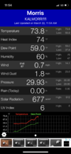
Same here, steady rise all morning, below is the temp/dew graph from my weather station69/53 and mostly cloudy with the sun in and out. The sun has been out most of the morning. Dew point was 39 at 5:45 this morning

.gif")
At least at this time, it doesn’t have that “feel” in the air but that may change later on this afternoonSame here, steady rise all morning, below is the temp/dew graph from my weather station
View attachment 116058
I am at 74/59 mostly sunny.Same here, steady rise all morning, below is the temp/dew graph from my weather station
View attachment 116058

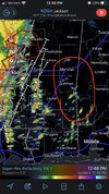
Moderate risk further northLatest day 1 just issued
View attachment 116063
Next truck commercial: "Chevy Silvarado. Best in class 10 years running. Your Tom Brady Sucks can be hit by a EF3 and you'll still drive away, so ditch your automatic tailgates and drive like a man"
Warm front riders lolInteresting

...Southeast into the Carolinas...
Showers and thunderstorms will likely be ongoing from eastern TN
southward to the western FL Panhandle. Widespread clouds and poor
lapse rates may limit downstream destabilization across GA and the
Carolinas ahead of this line, but abundant low-level moisture will
support at least modest buoyancy. A linear convective mode is
expected to dominant these storms, and vertical shear will be strong
and supportive of more intense updrafts capable of damaging wind
gusts and potentially few instances of embedded QLCS tornadoes.
Limited destabilization is currently tempering overall severe
probabilities. However, if confidence in greater boundary-layer
heating and destabilization increases, greater severe probabilities
may be warranted across GA and SC.
Higher potential to the south and west of us but a threat is still there. More sun and further north the higher dewpoints can surge will provide more fuel for later today. It should be late afternoon into evening before it gets here. I think it will come through here as a QLCS with embedded tornadoes. Best chance for any discrete and stronger tornadoes are further south and west along the MS/AL state line.Haven't been keeping up with this system much at all. How is the Huntsville area looking? Wind is pumping and the sun has been out.

Mesolow really helps force that line and march it eastI did notice the ARW really bows out the north end of the line into northern AL. Looks like that is starting to happen on radar.