I know i guess MRX will wait until tomorrow when they have greater confidence on potential impact.
-
Hello, please take a minute to check out our awesome content, contributed by the wonderful members of our community. We hope you'll add your own thoughts and opinions by making a free account!
You are using an out of date browser. It may not display this or other websites correctly.
You should upgrade or use an alternative browser.
You should upgrade or use an alternative browser.
Tropical Hurricane Nate
- Thread starter ForsythSnow
- Start date
Showmeyourtds
Member
FFC just pulled the trigger..along & north of the 85 corridor
Rosie
Member
Issued for this area.I know i guess MRX will wait until tomorrow when they have greater confidence on potential impact.
What a weird year. Two inland tropical storm watches within about a month. Very odd.
Sent from my iPhone using Tapatalk
Sent from my iPhone using Tapatalk
accu35
Member
We are under a TS Watch yet this is what it says:
WIND
- LATEST LOCAL FORECAST: Below tropical storm force wind
- Peak Wind Forecast: 20-30 mph with gusts to 50 mph
WIND
- LATEST LOCAL FORECAST: Below tropical storm force wind
- Peak Wind Forecast: 20-30 mph with gusts to 50 mph
Yellow Snow
Member
This is the criteria for a TS Watch - "possible" is the key word:We are under a TS Watch yet this is what it says:
WIND
- LATEST LOCAL FORECAST: Below tropical storm force wind
- Peak Wind Forecast: 20-30 mph with gusts to 50 mph
Tropical Storm Watch: An announcement that tropical storm conditions (sustained winds of 39 to 73 mph) are possible within the specified coastal area within 48 hours.
http://www.nhc.noaa.gov/watchwarn_changes.shtml
Xtreme Weather
Member
SUMMARY OF 700 PM CDT…0000 UTC…INFORMATION
———————————————-
LOCATION…21.4N 85.9W
ABOUT 90 MI…145 KM NE OF COZUMEL MEXICO
ABOUT 570 MI…915 KM SSE OF THE MOUTH OF THE MISSISSIPPI RIVER
MAXIMUM SUSTAINED WINDS…65 MPH…100 KM/H
PRESENT MOVEMENT…NNW OR 340 DEGREES AT 22 MPH…35 KM/H
MINIMUM CENTRAL PRESSURE…990 MB…29.23 INCHES
Little stronger per 7p advisory
Sent from my iPhone using Tapatalk
Storm5
Member
Accu35 is now under a TS warning
Sent from my SM-J320VPP using Tapatalk
Sent from my SM-J320VPP using Tapatalk
Xtreme Weather
Member
Not sure if posted but BMX updated wind risk

Will add winds and wind gust

Sent from my iPhone using Tapatalk

Will add winds and wind gust

Sent from my iPhone using Tapatalk
At that center position it's not going to landfall on the YucatanSUMMARY OF 700 PM CDT…0000 UTC…INFORMATION
———————————————-
LOCATION…21.4N 85.9W
ABOUT 90 MI…145 KM NE OF COZUMEL MEXICO
ABOUT 570 MI…915 KM SSE OF THE MOUTH OF THE MISSISSIPPI RIVER
MAXIMUM SUSTAINED WINDS…65 MPH…100 KM/H
PRESENT MOVEMENT…NNW OR 340 DEGREES AT 22 MPH…35 KM/H
MINIMUM CENTRAL PRESSURE…990 MB…29.23 INCHES
Little stronger per 7p advisory
Sent from my iPhone using Tapatalk
Sent from my SM-G955U using Tapatalk
Storm5
Member
That's a big west shiftNot sure if posted but BMX updated wind risk
Will add winds and wind gust
Sent from my iPhone using Tapatalk
Sent from my SM-J320VPP using Tapatalk
I didn't realize the models had trended that far west ? I thought it was only a 30 mile or so shift ?That's a big west shift
Sent from my SM-J320VPP using Tapatalk
Xtreme Weather
Member
Sure looks that way saving grace is probably it will only have about 24hrs or so in the GOM thus should keep intensity down...unless his thing pulls an Opal LoLAt that center position it's not going to landfall on the Yucatan
Sent from my SM-G955U using Tapatalk
Brent
Member
Still seems lopsided per recon so I'm not seeing anything crazy happening
also may not be fully stacked and the fast motion will make it hard to really go off
also may not be fully stacked and the fast motion will make it hard to really go off
Xtreme Weather
Member
Yup why I was mentioning earlier I thought maybe the graphics would change once they updated to show more of central AL involvedThat's a big west shift
Sent from my SM-J320VPP using Tapatalk
newest from NWS BMX
It will be interesting to see what happens as it completes this slingshot around the east side of the upper low. Most models have some strengthening occurring after that happens and the storm slowsStill seems lopsided per recon so I'm not seeing anything crazy happening
also may not be fully stacked and the fast motion will make it hard to really go off
Sent from my SM-G955U using Tapatalk

It will be interesting to see what happens as it completes this slingshot around the east side of the upper low. Most models have some strengthening occurring after that happens and the storm slows
Sent from my SM-G955U using Tapatalk
if it were to slow down say to 5-10 mph i honestly believe that would be a bad situation. much more time in the bath water that the gulf has right now

weatherguy
Member
The outflow has really been streaming out strong over the past 30 or 40 min, the storms seem to really be feeding off the deep warm waters in at least a half orderly fashion.
Xtreme Weather
Member
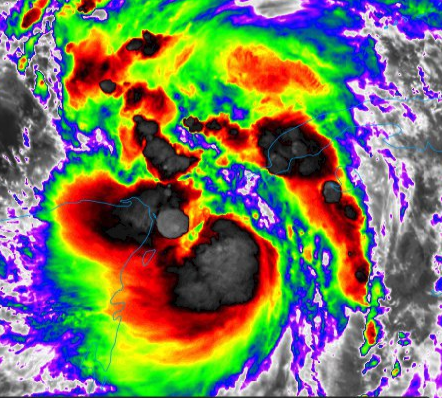
Interesting to see that the dry air (that was near the COC) is now being thrown out and the core is beginning to look better
850 winds impressive. Strong gust could make it down to the surface levels. In AL GA TN as the cyclone races northeast.


Xtreme Weather
Member
The SW is out of the way all up to Nate as to what he want to do dry air moistened up and again that sw is over by MX and E TX now shear is not present either aloft

Storm5
Member
More hurricanes this run

Sent from my SM-J320VPP using Tapatalk

Sent from my SM-J320VPP using Tapatalk
More hurricanes this run
Sent from my SM-J320VPP using Tapatalk
thats not fun
Maybe like a 12 mile SE shift on the 0z model consensus
Sent from my SM-G955U using Tapatalk
Sent from my SM-G955U using Tapatalk
Xtreme Weather
Member
Noticing some nice cooling top burst around the COC ESP the Southern flank and E side if this can close off wrap around the entire eye it’s game onMore hurricanes this run
Sent from my SM-J320VPP using Tapatalk
Needs some work on the NE quadrant. This this is really motoring along too. It's crazyNoticing some nice cooling top burst around the COC ESP the Southern flank and E side if this can close off wrap around the entire eye it’s game on
Sent from my SM-G955U using Tapatalk
Xtreme Weather
Member
Yup just looking at the loop it’s tryng to wrap around though esp last 3 frames or so...this where the drier air had worked in today and give impression to some an eye was forming...Needs some work on the NE quadrant. This this is really motoring along too. It's crazy
Sent from my SM-G955U using Tapatalk
ForsythSnow
Moderator
Very close to hurricane strength near the surface?

Saw the hurricane guy on TWC say, need to look for banding features to indicate strengthening, not pulse type blow ups at random locations.Needs some work on the NE quadrant. This this is really motoring along too. It's crazy
Sent from my SM-G955U using Tapatalk
Xtreme Weather
Member
He’s getting there outflow is looking much better as wellSaw the hurricane guy on TWC say, need to look for banding features to indicate strengthening, not pulse type blow ups at random locations.
http://www.ssd.noaa.gov/goes/east/gmex/h5-mloop-rb.html
Agree really looks like it's trying to get a cdo going but the fast movement makes me wonder where the center really isYup just looking at the loop it’s tryng to wrap around though esp last 3 frames or so...this where the drier air had worked in today and give impression to some an eye was forming...
If you look at microwave imagery it's got a nice area on the western half and would probably have a nice band wrapping around the storm if it didn't eat so much dry airSaw the hurricane guy on TWC say, need to look for banding features to indicate strengthening, not pulse type blow ups at random locations.
Sent from my SM-G955U using Tapatalk
My guess if we see a hurricane it will prob be a bit east of the western track imo. Still think near mobile area. Give or take east or west I would say at this point 80 mph
Storm5
Member
00z NAM landfall SE Louisiana
Sent from my SM-J320VPP using Tapatalk
Sent from my SM-J320VPP using Tapatalk
Nam HR 19 976 MB approaching LA
ForsythSnow
Moderator
Big convection explosion wrappingnl over the center now. Extremely cold clouds.
Stormlover
Member
TWC said there is now a 47% chance of it getting to 90, 31% chance of it getting to 100, 20% chance of 105, and 10% chance of 110More hurricanes this run
Sent from my SM-J320VPP using Tapatalk