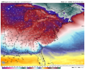
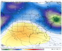
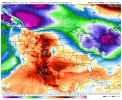
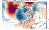
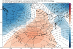
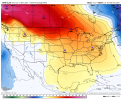
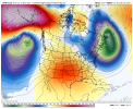
If this pans out that not bad at all and again nice trends. Also, if that is right, this means the true torch was only a handful of days and not wall to wall like it appeared might occur. SER is real but the SER on roids that models love to show in the extended the last couple of years always gets muted closer we get in time. Thanks to -NAO I suppose and of course if we lose that it could get ugly but for now again I'm loving the trends. Thanks for posting these daily man
-
Hello, please take a minute to check out our awesome content, contributed by the wonderful members of our community. We hope you'll add your own thoughts and opinions by making a free account!
You are using an out of date browser. It may not display this or other websites correctly.
You should upgrade or use an alternative browser.
You should upgrade or use an alternative browser.
Pattern December to Remember
- Thread starter SD
- Start date
Dewpoint Dan
Member
Just unbelievable what's about to unfold in IA and MN. Never seen a MDT risk in that area in Mid Dec. Also could be a serious situation with a lot of people losing power and then left in the cold.
Yeah. We got a mini mega frost this morning. Pretty good span of consecutive frosts the last several days.After going 29, 26, 28, 31 the last 4 mornings looking forward to a few warm mornings coming up
We locally caught a bit of a break with how the pattern set up to avoid the real super warm stuff at least for as long of a duration as we could have. The monthly mean should still end up ++++++ with at least 7-8 +10+ days which are hard to erase when the cold is seasonal.If this pans out that not bad at all and again nice trends. Also, if that is right, this means the true torch was only a handful of days and not wall to wall like it appeared might occur. SER is real but the SER on roids that models love to show in the extended the last couple of years always gets muted closer we get in time. Thanks to -NAO I suppose and of course if we lose that it could get ugly but for now again I'm loving the trends. Thanks for posting these daily man
If anyone this it's worthwhile I'll start a thread for the Iowa severe today since it's outside of the region but probably going to generate some discussion here
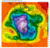
Some unbelievably cold air building up over the arctic and northwestern Canada on the GFS. I like the trough breaking off into a ULL, retrograding under the block south of the Aleutians. That would help to pump heights up out west and direct colder air into the SE. If the model is right and is too quick breaking down the -NAO, it will get really cold here with that look. But it's 384 hours out, so lol at this point, I guess. Anyway, better than seeing a big #golfweather SE ridge.

Downeastnc
Member
If anyone this it's worthwhile I'll start a thread for the Iowa severe today since it's outside of the region but probably going to generate some discussion here
Please do.
smast16
Member
26 here. Bottom fell out last night.Made it down to 30.7 before the clouds and fog rolled in
DonePlease do.
NBAcentel
Member
The GEFS now has the MJO not reaching phase 8 through the end of its run (12/29) though it is getting close then. Early on it straddles the border between 7 and 6:
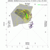
The Euro also doesn’t get to phase 8 by the end and is actually back into 6 early in the run. So, they don’t agree where the MJO is now:
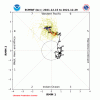

The Euro also doesn’t get to phase 8 by the end and is actually back into 6 early in the run. So, they don’t agree where the MJO is now:

whatalife
Moderator
The GEFS now has the MJO not reaching phase 8 through the end of its run (12/29) though it is getting close then. Early on it straddles the border between 7 and 6:
View attachment 98047
The Euro also doesn’t get to phase 8 by the end and is actually back into 6 early in the run. So, they don’t agree where the MJO is now:
View attachment 98048
I would assume this may bode well for colder air lasting well into January if we make a slow pass through 7,8,1…
Sent from my iPhone using Tapatalk
Remember that crazy happy hour GFS run with the apocalyptic SE winter storm run a few days ago? It had the bridge. Just saying.Ridge bridge trend in the medium range bodes well View attachment 98046
The GEFS has a -NAO and -AO starting shortly and remaining that way through the end: very nice for cold lovers!
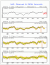
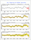
However, to get sustained dominant cold in the SE (I don’t mean cold just via wedges that are in and out), it would be very helpful to get rid of the -PNA, which is stubborn through the end of the run though hinting it may head to neutral late:
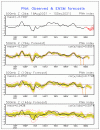


However, to get sustained dominant cold in the SE (I don’t mean cold just via wedges that are in and out), it would be very helpful to get rid of the -PNA, which is stubborn through the end of the run though hinting it may head to neutral late:

I know a guy! ?If anyone this it's worthwhile I'll start a thread for the Iowa severe today since it's outside of the region but probably going to generate some discussion here
When you set your record high at 5 am, and it’s already noticeably humid out, it’s a little scaryIf anyone this it's worthwhile I'll start a thread for the Iowa severe today since it's outside of the region but probably going to generate some discussion here
D
Deleted member 609
Guest
6 is no good in January right?The GEFS now has the MJO not reaching phase 8 through the end of its run (12/29) though it is getting close then. Early on it straddles the border between 7 and 6:
View attachment 98047
The Euro also doesn’t get to phase 8 by the end and is actually back into 6 early in the run. So, they don’t agree where the MJO is now:
View attachment 98048
I would assume this may bode well for colder air lasting well into January if we make a slow pass through 7,8,1…
Sent from my iPhone using Tapatalk
And also phase 2, another pretty chilly phase. It normally is great in combo with -NAO/-AO but the main fly in the ointment is the stubborn -PNA, which needs to go by January to give the best shot at longlasting dominant cold and not just in and out cold via wedging. At least getting to neutral would help.
6 is no good in January right?
Correct but no model keeps it in 6 other than within the next few days.
SnowNiner
Member
And also phase 2, another pretty chilly phase. It normally is great in combo with -NAO/-AO but the main fly in the ointment is the stubborn -PNA, which needs to go by January to give the best shot at longlasting dominant cold and not just in and out cold via wedging. At least getting to neutral would help.
I agree. Grit's twitter post gave me some nice encouragement and patience for January out west. I liked the description too of how this year, although similar it seems to this year, is a bit different in the Pacific with perhaps a better outcome for January. I hope he's right about the pacific jet and its effect on the ridging. If we can get it to come east in tandem with a -NAO, and a cold Canada, we'd be in business. I don't think I've seen a true -NAO/-AO/+PNA regime set up in my weenie days. It would be nice to see the outcome of that.
Just impatient looking at the meh as far as the eye can see on the models. And the MJO waffling is not helping.

BHS1975
Member
When you set your record high at 5 am, and it’s already noticeably humid out, it’s a little scary
Ooof and in DECEMBER no less. Weather going off the rails.
Sent from my iPhone using Tapatalk
Stephenb888
Member
Is there a legit chance of getting the pacific ridge to push further east sometime soon is it all wishful thinking?
Webberweather53
Meteorologist
It isn't. CFSv2 is always too fast w/ the MJO.
ICON has a great rainmaker
tennessee storm
Member
Correct sir6 is no good in January right?
NBAcentel
Member
Colder this run:


NBAcentel
Member
D
Deleted member 609
Guest
I will wait for Logan's analysis before getting hopes up.Gotta love the trend, this is quickly turning into a favorable pattern for the Carolinas if we can sneak some energy from the western trough View attachment 98063View attachment 98064
Can we please just close off retrograde the system off the WC under the ridge and stop the connection to the energy trying to find dive S through Canada? If we can't it's a chilly pattern but will be prone to moderate toward New YearsGotta love the trend, this is quickly turning into a favorable pattern for the Carolinas if we can sneak some energy from the western trough View attachment 98063View attachment 98064
NBAcentel
Member
That’s basically what grit said would possibly eventually happen lol. The only reason i like the -PNA in that case is the barrage of energy that could enter that confluence and we score that way, sort of like march 2018Can we please just retrograde the system off the WC under the ridge and clean that up? If we can't it's a chilly pattern but will be prone to moderate toward New Years
NBAcentel
Member
Gotta love the trend, this is quickly turning into a favorable pattern for the Carolinas if we can sneak some energy from the western trough View attachment 98063View attachment 98064
Aren't we starting to lose the -NAO here though? Got to keep that storm track South.
It doesn’t matter with the amount of CAD we’re about to see with that high pressure moving in … the kitchen sink has already been thrownAren't we starting to lose the -NAO here though? Got to keep that storm track South.
The GFS is finally retrograding the ridge into a +PNA!


Geez that would be ridiculously cold in early janThe GFS is finally retrograding the ridge into a +PNA!


