LukeBarrette
im north of 90% of people on here so yeah
Meteorology Student
Member
2024 Supporter
2017-2023 Supporter
FWIW Euro gave me all snow on the 0z as well. Maybe it’s the gfs that’s in the wrong now. We can pray.
FWIW Euro gave me all snow on the 0z as well. Maybe it’s the gfs that’s in the wrong now. We can pray.
It's JUST right after this time frame we turn it around... Remember! lol. But that is a ugly looking map, A lot of cold to the NW that should push, slosh, or jump to the SE in time.
 :
:Again. That’s 6z run way out fantasy …That modeled cold late in the 6Z GFS run is the coldest on the planet then and is hinted at by all of the ensemble means for around that time. At the very least, our primary source region of NW Canada is then frigid with sub -40F in spots. Here’s a global perspective and it is then moving SEView attachment 96887:

Don’t we want rain?I wouldn’t get hopes up the 06z euro/EPS took a decent step north for the system, gonna be close for @LukeBarrette tho
Lol a few more ticks south and I-40 would have been in business for snowflakes, but yes this is good for rain with the trend northDon’t we want rain?

Gonna turn that into a central US death ridge lol
Roxboro will always get theirsLol a few more ticks south and I-40 would have been in business for snowflakes, but yes this is good for rain with the trend north
Again. That’s 6z run way out fantasy …


What’s funny is the models are pointing at this death ridge eventually retrograding up towards Greenland and eventually our Greenland block shows up in force.. probably won’t be until the last week of December or soGonna turn that into a central US death ridge lol
What’s funny is the models are pointing at this death ridge eventually retrograding up towards Greenland and eventually our Greenland block shows up in force.. probably won’t be until the last week of December or so


Going to be some big time CADS in our future if we have this level of cold to play with View attachment 96898
Extreme warmth sometimes precedes extreme cold. I love to follow extremes on both sides even though I strongly prefer the cold. This month has a chance to be one of the warmest Decembers on record. Will be fun to follow. This would also set up the US for the chance for one of the coldest shifts on record from one month to the next. This could potentially set us up for a near normal winter in which the mean hides the reality of ridiculous extremes on both ends.
This says that fall storms are often tells, well I hate to break it to ya, but there was a very definite and noticeable lack of fall storms.Here's just a little of Joe D'Aleo post from Saturday.
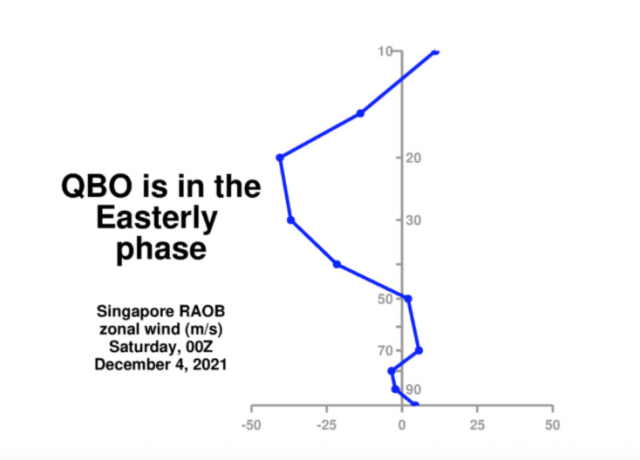
QBO easterly argues for cold periods. Key levels are 30-45mb.
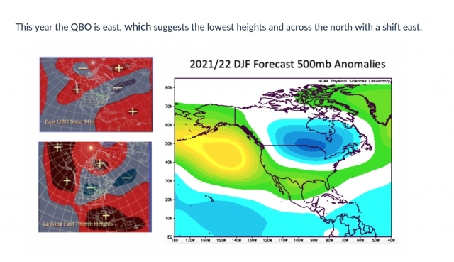
We will see this 'boot' of cold this winter. Many analogs had the cold early, others later when the stratosphere warms.
Then we could see major snow events that make the list. The October bomb could be a model then. The fall storms are often 'tells'.
So don't fret and don't whine just get your cold forecast where I get mine! And I'll be back on Christmas Day!
This says that fall storms are often tells, well I hate to break it to ya, but there was a very definite and noticeable lack of fall storms.


What’s funny is the models are pointing at this death ridge eventually retrograding up towards Greenland and eventually our Greenland block shows up in force.. probably won’t be until the last week of December or so
That's not how this works. A blocking ridge (or trough) that moves from west to east is definitely not "retrograding" because it's in the same direction as the background flow (which is also west to east), that would be actually be a "prograde" motion. What's far more likely happen to develop a -NAO from +NAO is the blocking high over the Barents Sea & Scandinavia would retrograde westward w/ time if the N Atlantic storm track is sufficiently excited by a slow moving, West Pacific MJO event that migrates into the western hemisphere.
See for example:
https://journals.ametsoc.org/view/journals/atsc/69/8/jas-d-11-0289.1.xml
On the other hand, for the NAO+ to NAO− transition events during P2, a comparison between Figs. 8b and 9b shows that the transition events coincide with the NAO− (NAO+) anomaly being markedly enhanced (weakened). A comparison between Figs. 8b and 9b also shows for the NAO+ to NAO− transition events that the SBL (Scandinavian Blocking) is enhanced and exhibits a westward-displaced position. The strengthening and westward-displaced position of the SBL (Scandinavian Blocking) within P2 takes place with the intensification of the NAO− anomaly. Thus, the NAO+ to NAO− transition appears to be connected to the excitation of the enhanced SBL (Scandinavian Blocking) pattern. These results suggest that the enhancement of the SBL (Scandinavian Blocking) pattern plays a role for the NAO+ to NAO−transition events. Thus, the NAO+ to NAO− transition event is likely to coincide with an increase in the amplitude and the westward-displaced position of the SBL (Scandinavian Blocking) pattern. As noted by Cassou (2008), a greater frequency of occurrence of the SBL (Scandinavian Blocking) can lead to an NAO+ to SBL (Scandinavian Blocking) to NAO− transition.
From Part II of this study
https://journals.ametsoc.org/view/journals/atsc/69/8/jas-d-11-0290.1.xml?tab_body=fulltext-display
"It is found that the NAO+ to NAO− transition is more likely to occur when the SBL (Scandinavian Blocking) is enhanced, with the route NAO+ to SBL to NAO− taking place."
An analogous result is found for NAO+ to NAO− transition events when the SBL is strong (Fig. 3b). The difference of the composite NAO index between the weak and strong SBL (Scandinavian Blocking) strengths is statistically significant at the 90% confidence level with a Monte Carlo test. This result indicates that an enhanced SBL (Scandinavian Blocking) pattern favors the transition from the NAO+ to the NAO− event.
Prior to the NAO+ event transiting into an NAO− event, the SBL is generally stronger because of the NAO being positive (Luo et al. 2007). It is found from Fig. 4b that during the NAO+ to NAO− transition the SBL strength is positive between lag −10 and lag +12, indicating a tendency to increase before lag 0 and then decrease until lag +4. A rapid reintensification of the SBL pattern is again seen after lag +4, followed by the beginning of its decay at about lag +7, after which it becomes negative at lag +12. Thus, the transition from an NAO+ to an NAO− event is closely related to a change in the SBL (Scandinavian Blocking) strength. Moreover, it is seen that the occurrence of the SBL precedes the formation of an NAO− event during the NAO+ transition (solid line in Fig. 4b). This is because the NAO− event arises from the retrograde displacement of the SBL (Scandinavian Blocking) pattern. Feldstein (2003) found that European blocks retrograde before an NAO− event forms. More recently, Sung et al. (2011) suggested that NAO− events tend to be preceded by a blocking ridge in the vicinity of northern Europe. Cassou (2008) noted that an enhanced SBL and NAO−, associated with the Madden–Julian oscillation (MJO), can be interpreted as being the consequence of the previous NAO+excitation. However, we see here that the reintensification of the SBL (Scandinavian Blocking) pattern is crucial for the NAO+ to NAO− transition
Also see
https://rmets.onlinelibrary.wiley.com/doi/abs/10.1256/qj.02.76?casa_token=qNmP7R8p9AYAAAAA:CsevTy9aIC0waYxRuOU0UFDPHVUhGVsW2V4fg0qZusYT3VV-kIEta7Ztu641gCuJlodkafAX8dFFAcw
https://agupubs.onlinelibrary.wiley.com/doi/abs/10.1029/2010JD015006
https://idp.nature.com/authorize/casa?redirect_uri=https://www.nature.com/articles/nature07286&casa_token=MeTwFkjjovUAAAAA:Fc9BuCbX5G3xULHwII3ZZML9qVRql5ktM90-q9jL5rK9670BKKCBjZ5NVi0eggY259ToVAHzZk_tLi_6


This is one of the warmest starts to dec for the US from what I can see on wxbell from 1981-2021View attachment 96909
The only years that compare to this so far is 1995, 1998, and 2012 from what I saw

Torch years lolWhat a trio!!!


