• Hello, please take a minute to check out our awesome content, contributed by the wonderful members of our community. We hope you'll add your own thoughts and opinions by making a free account!

Tropical Hurricane Jose

Does anyone know the last time a major hurricane struck GA, the Carolinas or the northern Gulf coast in October ?
I think Hurricane Hazel on Oct. 15, 1954 is it. I know once we hit Oct. 15, I feel like it is the unofficial end of hurricane season along the coast of the Carolinas.
at195409.gif

https://www.wunderground.com/hurricane/atlantic/1954/Major-Hurricane-Hazel
 
2. Jose could produce other direct impacts next week along portions
of the east coast of the United States from North Carolina northward
to New England, but it is too soon to determine what those impacts
might be or where they could occur. Interests along U.S. east coast
from North Carolina northward to New England should monitor the
progress of Jose during the next several days.
 
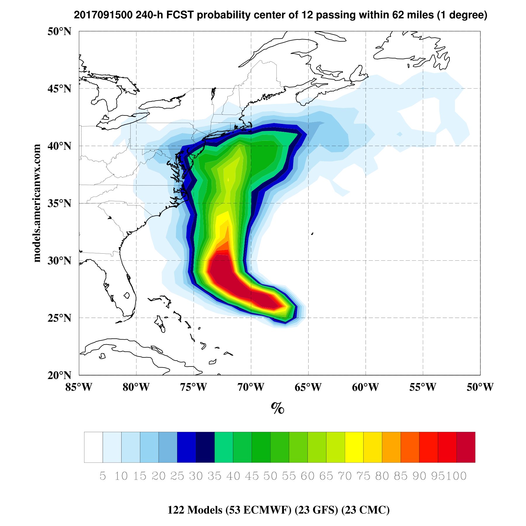
GFS keeps trending closer to the coast

this run is probably gonna hit somewhere around NYC or New England
 
00Z GFS - Jose heads to MA, then backtracks a loop back to the SW.:confused: Man, Jose can't catch a break from getting trapped underneath ridges. lol
 
While the majority are still offshore, that's a large spread imo even over just the next 72 hours.... also I recall just a couple days ago not a single EPS member showed a US hit
AL12_2017091500_ECENS_large.png
 
And from Allan Huffman.... this too is fairly wide, I think the threat to the mid-atlantic to the NE is increasing
DJw4v4zUEAAmmaZ.jpg:large
 
What a fascinating mess to watch

Sent from my SM-G955U using Tapatalk
It really is, I mean when you look at the EPS there's actually 2 members that take Jose into SC, 6 or 7 into NC and a handful more up the coast.... crazy, my gut says ots
 
Be interesting to see if Jose can make 75 west before crossing 30-32 North. If he does then someone up the coast is highly likely to get hit.
 
It really is, I mean when you look at the EPS there's actually 2 members that take Jose into SC, 6 or 7 into NC and a handful more up the coast.... crazy, my gut says ots
It does look like a nice plume of high pwat air is going to rotate into our area around Jose late Saturday into monday. Wouldn't be shocked to see some rain around

Sent from my SM-G955U using Tapatalk
 
It does look like a nice plume of high pwat air is going to rotate into our area around Jose late Saturday into monday. Wouldn't be shocked to see some rain around

Sent from my SM-G955U using Tapatalk
I'm counting on it along with a nice stiff N/NE breeze
 
Fwiw the NAM @84 is way east....
and Jose finally trying to get it's act back together oh and recon en route
 
When/if Jose hits New England, it's likely to maintain most of its tropical characteristics given the absence of large-scale upper level troughs in the vicinity that usually induces crosswise thermal advection and accelerates asymmetrization of concomitant convection (& therefore diabatic potential vorticity anomalies). Potential Vorticity essentially is the measure of the amount of vorticity a given amount of air would have if it was stretched or contorted down to a reference pressure &/or latitude and it's the combination total vorticity and static stability, areas with large static stability, such as the stratosphere, will have large potential vorticity and vis versa in the troposphere. Potential vorticity is conserved for adiabatic, frictionless flow, which also means non-conservative processes, such as convective overturning and low-level frictional convergence can create or destroy potential vorticity. In the case of tropical cyclones, latent heat release from convection helps generate large amounts of potential vorticity in the low-mid troposphere that initiates non-linear positive feedbacks that amplify pre-existing PV anomalies and augment the ambient low level vortex. This essentially means that the stronger a tropical cyclone becomes, the faster it can grow... These PV anomalies are found below the mean "level of maximum heating", wherein height falls occur below as the thicknesses expand due to diabatic warming and vis versa above this level. In layman terms, as a column of air warms, it expands, and above the point where this column is expanding the most, the heights rise (leading to higher pressure in the upper levels) & below, the heights fall, intensifying the low level vortex. (As an aside: the level of maximum heating is generally determined via the intersection of vertical velocity acceleration (which usually increases up through the mid troposphere) and condensational deposition, thus it's often found somewhere in the mid troposphere (~400-700 hPa)... As a TC intensifies, and the amount of heating in the mid troposphere increases, this low level potential vorticity below the level of maximum heating organizes into a tower and builds upwards. I.e. PV tower becomes taller and stronger as a TC intensifies. The height of the PV tower is often referred to as the "Rossby penetration depth". As its height changes in accordance w/ TC intensity, the layer averaged wind (i.e. steering flow) within the PV tower also changes, which also explains why two TCs of different intensities will travel in different directions given the same set of background conditions...

Graphic credit: Gary Lackmann
Screen Shot 2017-09-15 at 11.42.47 AM.png

Using IDV, I took a Potential Vorticity vertical cross section of the Potential Vorticity across Jose's vortex as he approached southern New England. Considering the aforementioned information, if Jose is still a warm core cyclone, we should expect to see a diabatic PV tower protruding upwards from the surface to the mid levels. That's exactly what we see below as indicated by the positive PV (in red) extending up to 400 hPa and maximizing around 500-600 hPa. In fact, the vertical juxtaposition of +PV is probably the most easily distinguishable characteristic that allows one to easily decipher between a cold core and warm core cyclone. Contrarily, cold-core extratropical cyclones are associated with extrusions of PV that extend from the stratosphere downwards into the troposphere and can even occasionally lead to profound tropopause folding...

Screen Shot 2017-09-15 at 10.56.46 AM.png

Screen Shot 2017-09-15 at 10.57.13 AM.png


TC phase space diagrams which use thickness symmetry and layer averaged thermal wind confirm the PV cross section and indicate Jose is still warm core cyclone as it approaches southern New England
1.phase1.png

1.phase2.png
 
Looks like we are back to a cat 1

164000 2658N 06947W 6966 03064 9871 +154 +112 069040 041 064 005 00
164030 2656N 06946W 6954 03069 9865 +152 +111 074044 048 066 005 00
 
While most of the guidance keep the center of Jose offshore for the
next few days, all of the global models show the hurricane becoming
rather large by late this weekend as it moves to the east of North
Carolina. For that reason, a tropical storm watch may be needed
for a portion of the North Carolina coast tomorrow.
 
Lol if someone didn't know what Jose's path was when looking at this map, they would think that he became two separate storms. :p This has to be the weirdest wind map a storm has produced.
204057_wind_history.png
 
I'm better off trying to solve a Sudoku puzzle than trying to make sense out of Jose's past, present and future track since it's inception.:confused:
 
Back
Top