L
Logan Is An Idiot 02
Guest
Very impressive with the cold. Everything else is meh. Wasting cold air
Very impressive with the cold. Everything else is meh. Wasting cold air
At least we're not wasting warm air.Very impressive with the cold. Everything else is meh. Wasting cold air
By the time the cold air gets here it will probably be warm. Then we can waste it.At least we're not wasting warm air.
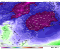
U dont see that cute Greenland block there? 1065mb FWIWI don't really like this set up... no ridging out west.View attachment 95991
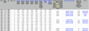
Nobody knows what to believe at this stageMeanwhile View attachment 95992
My Dad and Grandfather were at a GA Tech game, and the temp in Atl fell to 6 degrees at the end of the game.What was the result for us
The final low at KATL was 3, amazing outbreak..My Dad and Grandfather were at a GA Tech game, and the temp in Atl fell to 6 degrees at the end of the game.
If it’s so cold why can’t it just snowI mean Christ almighty! GFS high temperatures on December 7th!! grant it it’s not full sunshine but HOLY BALLS this is ridiculous for early December and would absolutely set the stage for an ice storm no doubt you can’t move cold air like thisView attachment 95996
Change that to anomaly , it has it as barely -16 lmao. The gfs thinks the average high is 44 on that day.I mean Christ almighty! GFS high temperatures on December 7th!! grant it it’s not full sunshine but HOLY BALLS this is ridiculous for early December and would absolutely set the stage for an ice storm no doubt you can’t move cold air like thisView attachment 95996
Think those were 850 anomaliesChange that to anomaly , it has it as barely -16 lmao. The gfs thinks the average high is 44 on that day.
Ignore other comment, looks like the 2m temps are low too. But I think they are in CChange that to anomaly , it has it as barely -16 lmao. The gfs thinks the average high is 44 on that day.
That makes sense . Why would anomalies be in C though.Ignore other comment, looks like the 2m temps are low too. But I think they are in C
To confuse AmericansThat makes sense . Why would anomalies be in C though.
That anomaly legend is in CelsiusNope shows this for anomalies when the high is 28! 28 is almost 30 degrees below normal . Color scheme is off .
View attachment 95997
Fortunately Weatherbell has temperature anomalies in Fahrenheit.Nope shows this for anomalies when the high is 28! 28 is almost 30 degrees below normal . Color scheme is off .
View attachment 95997

This makes it look colder. Lets use theseFortunately Weatherbell has temperature anomalies in Fahrenheit.
View attachment 95998
I dont know models seem to be in agreement that a big time cold shot is coming first week of December ensembles have been fairly consistent with this the past few days nowLike it's just comical at this point, the OPs and the ensembles are just pulling complete fricking 180s. I'm hoping this instance is just the 18z being the 18z but still, it's embarrassing.

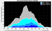
I just made this hurricane climo graph but now it's for snow/ice in NC instead ? It looks so damn cool lol I'm still tweaking the plot atm
View attachment 95993

Wow this is truly amazing stuff here. We may get into weenie bouts here sometimes but I’m truly so impressed with the stuff you’ve done for the stateCheck out this masterpiece
We finally have a nice climo chart like this to call our own in NC!
View attachment 96001
Doesn’t it only go out 144?Not a fan of the 18z EPS trend in the pacific
Notice the early December uptick in historic storms ????Check out this masterpiece
We finally have a nice climo chart like this to call our own in NC!
View attachment 96001
Yeah but the pacific already looked like a step in the wrong directionDoesn’t it only go out 144?
