? 
Got about an inch here.

.95 at the houseGot about an inch here.
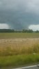
Heavy rain bands continue to move through … too bad this is suppose to be south of Charlestown
")


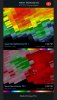
I mean models have been showing it start to regain intensity at this point for the last few days, but the mechanisms that are causing the strengthening isn’t tropical, so I’m not really sure how we can’t be referring to this as sub-tropical or even post tropicalSo let me get this straight. Claudette gets named after landfall and is now predicted to regain tropical storm status while still over land??View attachment 85609
SD getting dry slotted!Don’t know how we mess this one up .. we can’t right ? View attachment 85607
 ???
???Congrats, .21 thus far.95 at the house
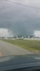
This lightning is insaneCongrats @SD i screwed it up so you could fly! View attachment 85610

This is wildYou lucky bastard View attachment 85614


Damn that sucks but that area S of sanford might give us another shot soon
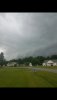
1.55 so far.


Nice.... still Jonesvilling up here1.55 so far.