Blue_Ridge_Escarpment
Member
Hahaha GFS folding up to the euro.


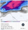
OuchImprovements in SW VA on the GFS as well View attachment 63634View attachment 63633

Dang I see, decrease for areas further East which makes sense given the warm nose ? looks better placed tbh nowOuch

Improvements in SW VA on the GFS as well View attachment 63634View attachment 63633

Despite the grim look on the front end-middle part of this storm that'll be dominated by warm advection, I do actually feel a lot better about the chances for accumulating moderate-heavy snow/sleet on the backend of this storm than I did yesterday or this morning in central NC. An inch or two is very much on the table imo just need to iron out some details on precisely where and how much
Why is that? Just a matter of colder air for the backend?

Have a feeling whatever will fall whether it’s sleet/snow will be quite heavy on the back side, those mid level lapse rates under that thing are impressive, just hope we can filter in cold correctly on the back side, because I’ve seen cases where the warm nose sticks around unexpectedly, and you get a sleet bomb basically as you just saidI mean it's just a mesoscale wrinkle that's very difficult to forecast more than several hours in advance &/or the morning or night before I'd say. I'm concerned the warm nose will be stronger than forecast and hold on longer than the models expect even once the cold advection really ramps up. This stronger initial warm nose could cut down on the lateral extent of snow/sleet and totals on the back end, and also would mean potential for more sleet over snow too in many areas.
Have a feeling whatever will fall whether it’s sleet/snow will be quite heavy on the back side, those mid level lapse rates under that thing are impressive, just hope we can filter in cold correctly on the back side, because I’ve seen cases where the warm nose sticks around unexpectedly, and you get a sleet bomb basically as you just said
That EURO run was tuff to see this close in but I am holding out some hope!This looks like a @Nomanslandva crush job
Your fine in this setup, tbhThat EURO run was tuff to see this close in but I am holding out some hope!

Oh I am extremely hopeful for you believe me haha. It’s to the point where I’m gonna be chasing up that way.That EURO run was tuff to see this close in but I am holding out some hope!
Christiansburg or Wytheville may be better to get some of the early stuff too. But whoever gets under that NE to SW oriented band pushing NW will have some fun. Several models showing that now. HRDPS looks fun too. So Hillsville or Stewart might be jackpots. Best wishes on your chasing!Oh I am extremely hopeful for you believe me haha. It’s to the point where I’m gonna be chasing up that way.


I think Fancy Gap could be a really good spot. High elevation, but a little further south so they may get more precip to work with. Plus could they get some upslope against the edge of the mountains there?Christiansburg or Wytheville may be better to get some of the early stuff too. But whoever gets under that NE to SW oriented band pushing NW will have some fun. Several models showing that now. HRDPS looks fun too. So Hillsville or Stewart might be jackpots. Best wishes on your chasing!
View attachment 63664
Agree, somewhere down that way should get smoked!I think Fancy Gap could be a really good spot. High elevation, but a little further south so they may get more precip to work with. Plus could they get some upslope against the edge of the mountains there?
Lol!! "Just in case" forecasting.Meanwhile, WRAL is talking about more than an inch of snow.

It's not a bad starting point for the airport/brier creek/wake forest areas and points northwest. It's a different world up there, my best winter in the last 10 years was when I lived in Brier CreekLol!! "Just in case" forecasting.

This would likely be my call map on 6:1 or 7:1 ratios. Closer to 8:1 or 9:1 in WNCMove that stuff around South Charlotte north and there’s my answerView attachment 63691View attachment 63692
I like your map. Only thing I would do differently is pull the northern half of the white east one layer of counties to take in Johnston, Wilson, Nash, edgecombe, Halifax and Northampton. Think there might be enough left in the deformation band to clip them on the way outMove that stuff around South Charlotte north and there’s my answerView attachment 63691View attachment 63692
Someone there is salty....lol
Throwing some scattered light accum pockets south of 85. Jimmy like
You got the upper end forecast map?
.png")