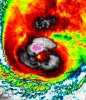
Tropical Hurricane Zeta

  • Hello, please take a minute to check out our awesome content, contributed by the wonderful members of our community. We hope you'll add your own thoughts and opinions by making a free account!
While the
sustained winds have been coming down, the satellite presentation is
actually not very degraded for a system that has been over land for
this long, and there have been reports of 100-mph wind gusts during
the past couple of hours.

Note that the wind gust factor for this hurricane is higher than
typical for a tropical cyclone, and that is reflected in the
Forecast/Advisory product.

PRESENT MOVEMENT...NE OR 40 DEGREES AT 31 MPH...50 KM/H
 
0fa394b4e8d0d942df7574e1291a6058.jpg


This is where it looks to be going to me. Obviously my line isn’t the straightest


Sent from my iPhone using Tapatalk
 
  • Like
Reactions: Bham 99
While the
sustained winds have been coming down, the satellite presentation is
actually not very degraded for a system that has been over land for
this long, and there have been reports of 100-mph wind gusts during
the past couple of hours.

PRESENT MOVEMENT...NE OR 40 DEGREES AT 31 MPH...50 KM/H
With such a rapid forward movement, I would think that this would enhance the winds significantly in the right front quadrant of this system.
 
  • Like
Reactions: Brent
Still sticking with original thoughts... the I-85 corridor between Mongomery and the Triad/Triangle... are in rude awakening tomorrow. Especially the Carolina's. Still think we have some sig gusts. Atlanta will have more tree damage/power outages because of population, pines, plus it's closer to the path. But I won't be shocked if there 1 million people without power sometime in between tonight/tomorrow. Stay safe tonight!