Odd it’s moving so fast it was going around 9mph this would have been a CAT5 easily.
-
Hello, please take a minute to check out our awesome content, contributed by the wonderful members of our community. We hope you'll add your own thoughts and opinions by making a free account!
You are using an out of date browser. It may not display this or other websites correctly.
You should upgrade or use an alternative browser.
You should upgrade or use an alternative browser.
Tropical Major Hurricane Laura
- Thread starter GaWx
- Start date
Looks like it’s still strengthening to me. Structure continuing to improve and the eye is contracting some it appears. Pressure is likely in the 940s.
Could be, but I see no really big surprises right now. Now that could definitely change as we head toward evening.
Henry2326
Member
Yup....when the NAM and HWRF are bombing out 3 and 4 days prior usually mean prime conditions can happen....I think we are witnessing it.It was 110 at the 5am, 9 hours later its 135. Folks, a 5 might happen. Hope to God not

Stormsfury
Member
Might be wrong here but I am not seeing that much of a sign of shear. Cirrus canopy is still expanding to the west and SW of the system instead of stacking up like you would typically see as a system is approaching shear or shear is approaching
If anything, the shear expected could actually FAVOR further intensification since initially if it does start to impact Laura, it will likely enhance the poleward outflow channel initially.
2 things I don't foresee happening.
Not likely to see an ERC...
Not likely to see shear disruption before its too late...
The only thing I can foresee halting the intensifying process right now is shallow shelf waters...
Henry2326
Member
HWRF has it forecasted at 945 at 6:00 this afternoon, HMON at 944, NAM at 941. Let's see if it outruns the forecast.Could be, but I see no really big surprises right now. Now that could definitely change as we head toward evening.
HWRF AND HMON get no lower after that point....
Considering that it's already at 952, I'm going to guess, yes it will outrun it.
ajr
Member

135-140kts about 1000 ft up...
Euro just showed 934 mb prior to lf with 940 at lf
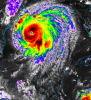
Eye is tightening up. Those meso vorts are going to connect soon.
EURO near CAT5
Henry2326
Member
If they do, Katie bar the door.....Eye is tightening up. Those meso vorts are going to connect soon.
HWRF has it forecasted at 945 at 6:00 this afternoon, HMON at 944, NAM at 941. Let's see if it outruns the forecast.
HWRF AND HMON get no lower after that point....
Considering that it's already at 952, I'm going to guess, yes it will outrun it.
If it grabs that extra gear let’s say around 5-6pm, it may make a run at Cat 5.
Question. I don’t remember, but isn’t a smaller eye indicative of a more powerful TC? Rather if it has a large eye and starts to close in (eye gets smaller) isn’t that indicative of a deepening TC?
Definitely a bit reminiscent of Michael with rapid intensification right before landfall.
D
Deleted member 527
Guest
I know it being classified as an official Cat 4 or Cat 5 for history and record books matter but for those in path of this storm. 5-10 mph is not going to matter to them as we all know. High end Cat 4 is going to leave Cat 5 damage. Not picking on anyone at all just saying it’s going to suck for many.
Henry2326
Member
Yup....2 words......LEAVE NOW!!I know it being classified as an official Cat 4 or Cat 5 for history and record books matter but for those in path of this storm. 5-10 mph is not going to matter to them as we all know. High end Cat 4 is going to leave Cat 5 damage. Not picking on anyone at all just saying it’s going to suck for many.
Looks like a turn to the N/NW, could just be a wobble but it's definitely jogged north
GET OUT NOW
NRVWX
Member
Look to already have that "stadium effect" look to the eye.
Jeff Piotrowski said there's already chasers stuck on the LA coast due to rising water.
Henry2326
Member
Pressure down to 944.9 mb.309
URNT15 KNHC 261840
AF307 2313A LAURA HDOB 25 20200826
183130 2712N 09222W 6968 02805 9644 +136 +136 248111 112 098 016 00
183200 2712N 09223W 6969 02787 9609 +139 //// 252101 111 094 008 01
183230 2713N 09224W 6970 02768 9579 +144 //// 253090 096 087 005 01
183300 2714N 09225W 6960 02767 9539 +152 +138 253080 087 080 003 00
183330 2715N 09226W 6976 02743 9514 +169 +133 254070 077 072 004 03
183400 2717N 09227W 6968 02727 9470 +196 +119 252043 066 058 002 00
183430 2718N 09228W 6968 02715 9449 +212 +082 240022 032 051 002 00
183500 2720N 09229W 6966 02711 9447 +210 +074 224012 017 030 001 00
183530 2721N 09231W 6967 02714 9462 +194 +093 206008 009 026 000 00
183600 2722N 09232W 6966 02721 9466 +191 +102 234006 010 023 001 03
183630 2723N 09233W 6963 02715 9454 +199 +086 149003 006 025 001 00
183700 2725N 09234W 6964 02716 9449 +205 +082 058004 006 024 001 00
183730 2727N 09235W 6975 02702 9455 +198 +095 068012 015 022 001 00
183800 2728N 09236W 6970 02711 9467 +185 +104 059020 022 029 002 00
183830 2729N 09238W 6971 02715 9480 +181 +104 042032 037 049 002 00
183900 2731N 09239W 6967 02729 9500 +170 +121 043044 048 076 004 00
183930 2732N 09241W 6976 02740 9533 +155 +136 036060 067 104 005 00
184000 2733N 09242W 6954 02786 9567 +154 +147 039078 086 104 004 00
184030 2734N 09243W 6966 02796 9623 +150 +150 041095 099 105 023 00
184100 2734N 09243W 6966 02796 9656 +145 +145 045100 102 105 035 00
$$
Henry2326
Member
Its running 3 hours ahead of forecast. HWRF AND HMON 12Z had it at 945 and 941 at 6:00 pm today, without any further intensity.Pressure down to 944.9 mb.
NAM 12z had it forecasted at 941 at 6:00 pm headed to 908 at landfall.
NWMSGuy
Member
My eyes could be playing tricks on me but is she turning North already?
BufordWX
Member
That outer band is really starting to get some areas of rotation going. I count 3 tornado warnings now. I’m surprised the SPC hasn’t posted a Tornado Watch yet.

BufordWX
Member
Four now, dang...That outer band is really starting to get some areas of rotation going. I count 3 tornado warnings now. I’m surprised the SPC hasn’t posted a Tornado Watch yet.View attachment 47400

There is no doubt she's gaining latitude, approaching 28N quickly....My eyes could be playing tricks on me but is she turning North already?
Darklordsuperstorm
Member
Looking wicked 


Henry2326
Member

ajr
Member
I had to look this up -- those 137-141kt readings are only about 100m up...
Henry2326
Member
LEAVE NOW!!!
Darklordsuperstorm
Member
6 tornado warnings up now!
Henry2326
Member
BufordWX
Member
Tornado warning for Baton Rouge now...
NBAcentel
Member
Eye is really warming now, getting that legit buzzsaw look to it now, that eye clearing is just a sign that ----- gonna get more real, quite incredible to watch but also sickening
Henry2326
Member
Uh Huh.....
snowlover91
Member
I’m not seeing any signs of an ERC on radar or via recon data. This likely intensifies up until landfall like Michael and Harvey imo.