Storm5
Member
Some nice rain headed for central Alabama
Sent from my iPhone using Tapatalk
Sent from my iPhone using Tapatalk
Time for model watchin'Atlanta news has just said that the gulf convection is robbing the energy from the front. At the moment it looks like they're not expecting severe. However, he did mention that if it were to gain some energy it could still fire up in the overnight.
Also said that he's expecting a severe outbreak around Monday.


Victory
Sent from my iPhone using Tapatalk
It bothers me that you're not using SuperRes.Victory
Sent from my iPhone using Tapatalk

It bothers me that you're not using SuperRes.
OMGCould use the rain I-85 in ATL just caught on fire and collapsed!!!
http://www.wsbtv.com/news/local/atlanta/large-fire-shuts-down-interstate/507589453
I saw that I-85 collapsed on another forum. Part of a bridge just caught on fire and collapsed. Someone for Georgia DOT is going to get fired because it was because of chemicals/gas under the road and it simply caught fire.
Its more exciting then the weather that's for sure
Yep. Afraid it is. Commutes tomorrow are going to be a nightmare in an already nightmarish corridor.
Sent from my iPhone using Tapatalk
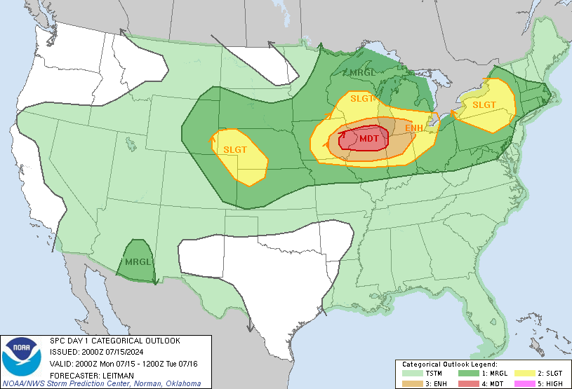
I'm not being critical at all, but could this have possibly been SPC's biggest bust ever. We all know threats can bust due to different things, but there isn't a single report of severe weather even close to the Moderate risk area. I don't even know if much thunder occured.
Whoops. Should have read this thread before the banter thread lol. Posted over there about it.I saw that I-85 collapsed on another forum. Part of a bridge just caught on fire and collapsed. Someone for Georgia DOT is going to get fired because it was because of chemicals/gas under the road and it simply caught fire.
Already have a warning in north GeorgiaDefinitely underwhelming as far as scope but still some storms popping up on AL/GA border which are gaining some strength which will be a little bumpy for some
Lightning looking pretty strong in Dallas gaAlready have a warning in north Georgia
I remember plenty of events that busted, I just don't remember one where there were no severe reports at all in the greatest risk area.It was no doubt a bust but I remember several events that busted with moderate outlooks. So I wouldn't call this the biggest bust ever. And there were a few tornado warnings in the enhanced are this afternoon in Illinois . It was a but down this way for sure
Sent from my iPhone using Tapatalk
Yep it's been nice this morning.... be better if I were at home instead of watching it out of an office window but oh well. I'm interested to see if we can clear out enough to destabilize after these storms this morningPouring this morning with some wind and lightning. I am intrigued by this afternoon if we can get some midday sun to see a nice line with quite a bit of hail and wind
I'm interested in the cell in NW Wake right now looks like it has a weak rotation. The NAM 3k seems like it might run a little hot to be honest. THe HRRR is less enthusiasticYep it's been nice this morning.... be better if I were at home instead of watching it out of an office window but oh well. I'm interested to see if we can clear out enough to destabilize after these storms this morning
Looks like the 3k NAM really likes that line this afternoon
I was in a meeting so didn't see the cell in Wake (or get to look at any others too closely) and I've noticed the HRRR is definitely less enthusiastic.... man this stuff ramping up down eastI'm interested in the cell in NW Wake right now looks like it has a weak rotation. The NAM 3k seems like it might run a little hot to be honest. THe HRRR is less enthusiastic