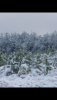
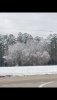
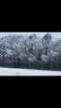
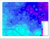
Sounds like QPF forecasts were pretty in line with what happened, then. At go time, the only one that was obscenely off was yesterday’s 12z RGEM, she spit our a ridiculous 1” QPF for RDU.RDU received 2.5" of snow with .47" of QPF. That close to 1:5 ratios (I'm sure it was lower for folks south of there). If it had been 1:10 (normal) ratios we would have seen 5-7" readings across the Triangle. But not complaining. Glad for what I got.
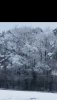
I think places like GSO may have gotten a little more liquid equivalent than forecasted.
Last edited:

.png")

.png")