Six Mile Wx
Member
Gfs 12z Friday and Saturday events. GFS has almost lost the Saturday event 


I'll take that little car topper and call it a Winter, a sucky winter but a winter none the lessSref mean for Saturday View attachment 33210

Sorry to ask but do you have this with the Timeline for GA and ensembles. I've tried pulling these and can never figure it outlooking good for MS/Al

I know they are not the best but the SREF plumes do show a good coating in Rome, GA and adjacent areas.


I was just about to mention how the soundings look around CLT. This is obviously gonna be another rate dependent deal for us.3km shows rain for areas around CLT but snow could make it to the surface with this look, I like those steep 700-500mb LRs and strong lift in the DGZ, May help things turn a little Convective and increase rates
Same thing for the upstate of SCView attachment 33267View attachment 33268

Looks like tomorrow. I should add by coating I mean a dusting which I will gladly take.When?
If the 3k NAM is overly wet aggressive biased for Friday morning, I’m sure not gonna trust it over the others on Saturday.


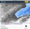
Potent little system all way around on some models. I still think Ga and upstate sees snow out of this. May not be much but hey better than nothingMaybe a little surprise in Georgia outside of the mtns. Sure is a potent 1” swath. Latest HRRR. View attachment 33296


I wouldn't call model output set in stone. At this point that moisture blob in N MS is something to be watched. There might be a lot more moisture than modeled.Wish there was more moisture with this, only seems like two bands will set up in central Alabama.
Further west in north Alabama you are, the better odds.I am really thinking this surprises a few in North central alabama tonight. Someone is waking up to a .5 inch or 1 inch of snow in the morning. Not sure where that will be, but this is interesting.