-
Hello, please take a minute to check out our awesome content, contributed by the wonderful members of our community. We hope you'll add your own thoughts and opinions by making a free account!
You are using an out of date browser. It may not display this or other websites correctly.
You should upgrade or use an alternative browser.
You should upgrade or use an alternative browser.
Tropical Major Hurricane Humberto
- Thread starter GeorgiaGirl
- Start date


Right! Seems doesn't matter if a TC is a Cape Verde or homegrown they all turn into long trackers....Yep stuck between 2 ridges with a trough to the NE. Where have we seen that before?
Sent from my SM-G975U using Tapatalk

Only problem with it milling around over water is the high to the NE building back in, you would think that would push it inland.... of course it sits out there for 3-4 days upwelling and weakening should ensue. Of course 3-4 days of tropical rains would have people inland crying mercy too.....
F-5
Member
Looks like it’s time to bust out the Sharpie for us parched Bama folks.
I wouldn't get too deep into the track right now since we really don't have an identifiable center. Basically all we know is the stronger systems will likely trend east a weaker system would be west.
Sent from my SM-G975U using Tapatalk
Sent from my SM-G975U using Tapatalk
That's a great point. Stronger is east for sure.I wouldn't get too deep into the track right now since we really don't have an identifiable center. Basically all we know is the stronger systems will likely trend east a weaker system would be west.
Sent from my SM-G975U using Tapatalk
What’s interesting between 95L vs Dorian is that this time around quiet a few spaghetti models dig inland on various east coast states. Dorian consistently had a void over western NC and verified well east. Everyone is at play so far which is nice for a change. Hats off to Levi yesterday morning for saying it will be tilted east with the convection until it develops and models would likely slow it down (now seeing the stalls) and major track changes as a result (which occurred today).
Henry2326
Member
NHC....covering the bases....that's a big cone....working hard to find the center so this cone has some guidance to it.
.png")
Last edited:
Henry2326
Member
Levi's latest....What’s interesting between 95L vs Dorian is that this time around quiet a few spaghetti models dig inland on various east coast states. Dorian consistently had a void over western NC and verified well east. Everyone is at play so far which is nice for a change. Hats off to Levi yesterday morning for saying it will be tilted east with the convection until it develops and models would likely slow it down (now seeing the stalls) and major track changes as a result (which occurred today).
NAM weak and in the GOM and the ICON continues with the east track, slow mover just offshore... yay
GeorgiaGirl
Member
GFS is gonna head to the gulf again and be a weaker, sheared out mess but also hopefully help a little with rain.
I think based off what I saw from the Euro though, I'll have seen enough if it has a stronger solution again. We'll of course discuss it and go over it for the next few days but it'll be obvious enough the GFS and other solutions are probably out to lunch.
I think based off what I saw from the Euro though, I'll have seen enough if it has a stronger solution again. We'll of course discuss it and go over it for the next few days but it'll be obvious enough the GFS and other solutions are probably out to lunch.
@180 finally moving north on the ICON with whatever the wave coming off Africa name will be at that time in tow....

@ForsythSnow not only does the ICON say no rain for you but you get west side TC subsidence induced heat wave

Shaggy
Member
@180 finally moving north on the ICON with whatever the wave coming off Africa name will be at that time in tow....
View attachment 23464
The concern for us here in NC on the icon would be how far east it got before it returned to the north movement. It has to clear hatteras or it would be another hit. Of course this also the icon.
@180 finally moving north on the ICON with whatever the wave coming off Africa name will be at that time in tow....
View attachment 23464
That will be a very, very dangerous solution if the ridge builds in like the Euro depicted and you get some sort of Fujiwara dance.
Not where I am. NE part of N.C.
Code RED
Btw their cone mostly goes into the Gulf
View attachment 23405
Widespread cloudiness and showers extending from the southeastern
Bahamas northward over the southwestern Atlantic for a few hundred
miles are associated with a sharp trough of low pressure. Although
limited development of this system is anticipated tonight and
Thursday, conditions are forecast to become a little more conducive
for tropical cyclone formation over the weekend, and a tropical
depression is likely to form as the system moves slowly toward the
west-northwest across the Florida Straits and southeastern Florida,
and into the eastern Gulf of Mexico. This disturbance will likely
produce periods of locally heavy rainfall and gusty winds across the
Bahamas through Friday, and across Florida during the weekend. An
Air Force Reserve reconnaissance aircraft is scheduled to
investigate the system Thursday afternoon, if necessary.
* Formation chance through 48 hours...medium...50 percent.
* Formation chance through 5 days...high...70 percent.
And Alabama!!! LOL
GeorgiaGirl
Member
Not bad, too bad this solution might be (okay probably is) out to lunch. It'd be even better if the green areas were filled in a bit more:

SnowE73
Member
I really hope the ICON is wrong (it's beginning to feel like Arizona here). Last nights Euro makes me think that this will be stronger and go east. Still don't have a well defined center so hopefully it will stay weak and go more west.@ForsythSnow not only does the ICON say no rain for you but you get west side TC subsidence induced heat wave
View attachment 23465
NBAcentel
Member
It’s no wonder why the GFS is weak/showing what it’s showing (weak gulf solution), it’s saying that one, more southwestern center of circulation will remain the dominant one hence it would probably have a better chance of moving out into the gulf, the ICON/EURO on the other hand has that center more to the East that wins out, which make more sense and would mean a more northernly jog into the Gulf Stream, in this setup it all depends on where a blowup of Convection develops allowing sfc vorticity hence a new center some miles east or west make the huge difference, I’m thinking something in between all this mess, there’s also other things impacting this like the ridge and ULL 

Henry2326
Member
Do you mind posting it when you get a chance? It appears to be a lead dog in this hunt. LolUK looks close to its 0z run. Just off the SE coast
Do you mind posting it when you get a chance? It appears to be a lead dog in this hunt. Lol
Not the best maps but all you go for another 30 mins.
http://www.meteociel.fr/modeles/ukmo2.php?nh=1&ech=72&carte=1021
Henry2326
Member
Thanks- I can wait 30 minutes....haNot the best maps but all you go for another 30 mins.
http://www.meteociel.fr/modeles/ukmo2.php?nh=1&ech=72&carte=1021
12Z UKMET: staying OTS as mentioned. That's quite interesting for a model with an overall left bias. Intriguing really.
NEW TROPICAL CYCLONE FORECAST TO DEVELOP AFTER 36 HOURS
FORECAST POSITION AT T+ 36 : 25.6N 76.6W
LEAD CENTRAL MAXIMUM WIND
VERIFYING TIME TIME POSITION PRESSURE (MB) SPEED (KNOTS)
-------------- ---- -------- ------------- -------------
0000UTC 14.09.2019 36 25.6N 76.6W 1008 32
1200UTC 14.09.2019 48 26.7N 78.0W 1007 32
0000UTC 15.09.2019 60 28.3N 79.2W 1001 44
1200UTC 15.09.2019 72 29.7N 79.7W 991 61
0000UTC 16.09.2019 84 30.8N 79.3W 973 69
1200UTC 16.09.2019 96 31.7N 78.5W 964 72
0000UTC 17.09.2019 108 32.2N 77.4W 948 76
1200UTC 17.09.2019 120 32.7N 76.1W 937 88
0000UTC 18.09.2019 132 33.1N 74.3W 931 93
1200UTC 18.09.2019 144 33.5N 72.2W 930 89
NBAcentel
Member
While this may seem weird, I think the 3km Nam looks good right now, something in between
ForsythSnow
Moderator
Literally its adding insult to injury. Why does the icon have to do this to us?@ForsythSnow not only does the ICON say no rain for you but you get west side TC subsidence induced heat wave
View attachment 23465
NBAcentel
Member
Literally its adding insult to injury. Why does the icon have to do this to us?
Welp dry ground = somewhat drier air/higher temps so it would make it harder for a storm to barrel in and max high temps would likely verify higher, that sucks ?
Henry2326
Member
12z CMC moves east on and off coast through FL. Let's hope nothing spins up with that scenario....
NBAcentel
Member
Since it’s a weaker storm vs what Dorian was, 250mb trough in GA is pulling/tugging it in a bit more effectively 
If we are lucky euro will trend east more and catch the next storm and tow it out to sea too! 2 for 1 from Humberto (the storm that replaced Hugo)!

12z CMC moves east on and off coast through FL. Let's hope nothing spins up with that scenario....
Thankfully, that kind of track (along or near the coast) would obviously keep a lid on the strength due to a combo of land interaction and slow movement resulting in cooling of the SSTs underneath it such as was the case with Dorian. However, the main problem though would be the enormous amounts of rainfall. The heavy rainfall aspect could easily turn out to be the biggest headache from this very slow mover, especially if it as a flood proned place like CHS.
Exactly Canadian rides inland all the way up Florida Coast at 12z, floods eastern SC GA NC. Gets drizzle right up to the neighbors house across the street from Shettleys house and stops.
Speaking of droughts where's Shettley been. This has turned into prime time for him
Speaking of droughts where's Shettley been. This has turned into prime time for him
NBAcentel
Member
Welp CMC would be terrible, sh*t would be flowing into the ocean again with that look like Matthew and Florence
GeorgiaGirl
Member
CMC is a big flood problem again. Yikes.

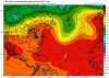
Doesn't even include NC yet but I wanted to post this one for emphasis because it has some totals (as of then) and is slightly better color coded.
Doesn't even include NC yet but I wanted to post this one for emphasis because it has some totals (as of then) and is slightly better color coded.
Storm total from CMC

Last edited:
Henry2326
Member
OMG......no wonder the flooding on CMC...,look at it spin in place....