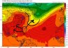
Based on the NHC finally mentioning this, I think the wave that we’ve been discussing quite a bit recently and that is currently exiting Africa is now worthy of its own thread:
“A tropical wave currently near the west coast of Africa is expected
to move quickly westward during the next several days. Some slow
development is possible late this week or over the weekend when the
system is several hundred miles east of the Lesser Antilles.
* Formation chance through 48 hours...low...near 0 percent.
* Formation chance through 5 days...low...20 percent.
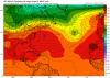
Earlier today I had said this: “My thinking right now for CONUS is pretty logical and based on model consensus of the last few days: if it is 250 or so miles north of the Caribbean or further north, there’d be an excellent chance for OTS from CONUS. But if it is just north of or in the Caribbean, trouble would likely be ahead.”
The just released 12Z GEFS illustrates this quite well. About 2/3 of the 21 or so members track near or to the right of the 12Z GFS close CONUS miss. All of these also miss and mainly further out. However, 1/3 of the members (7) are to the left (closer to or in the far N Caribbean). Every one of these either hits, barely misses, or ends the run about to hit the CONUS with a big H. The concerning thing on this run is that this 1/3 is higher than the prior 3 GEFS. It includes 5 of the 21 total members getting into the Gulf. All 5 subsequently end up turning NNE before either hitting or about to hit FL (anywhere from panhandle south to SW FL) at hour 384. The scary thing is that is a climo favored track from late Sep through Oct.
“A tropical wave currently near the west coast of Africa is expected
to move quickly westward during the next several days. Some slow
development is possible late this week or over the weekend when the
system is several hundred miles east of the Lesser Antilles.
* Formation chance through 48 hours...low...near 0 percent.
* Formation chance through 5 days...low...20 percent.
Earlier today I had said this: “My thinking right now for CONUS is pretty logical and based on model consensus of the last few days: if it is 250 or so miles north of the Caribbean or further north, there’d be an excellent chance for OTS from CONUS. But if it is just north of or in the Caribbean, trouble would likely be ahead.”
The just released 12Z GEFS illustrates this quite well. About 2/3 of the 21 or so members track near or to the right of the 12Z GFS close CONUS miss. All of these also miss and mainly further out. However, 1/3 of the members (7) are to the left (closer to or in the far N Caribbean). Every one of these either hits, barely misses, or ends the run about to hit the CONUS with a big H. The concerning thing on this run is that this 1/3 is higher than the prior 3 GEFS. It includes 5 of the 21 total members getting into the Gulf. All 5 subsequently end up turning NNE before either hitting or about to hit FL (anywhere from panhandle south to SW FL) at hour 384. The scary thing is that is a climo favored track from late Sep through Oct.
Last edited:


")