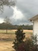
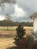
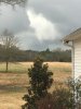
• Hello, please take a minute to check out our awesome content, contributed by the wonderful members of our community. We hope you'll add your own thoughts and opinions by making a free account!

Severe Severe Weather Potential February 23rd

Tuscaloosa radar
Also storm south of carbon hill with broad rotation
 

Attachments

  • 607048C7-F597-42FE-9213-70F26AA297A1.jpeg
    607048C7-F597-42FE-9213-70F26AA297A1.jpeg
    618 KB · Views: 27
Can’t tell whether this is a wall cloud or shelf, looks like a wall cloud in my opinion C402743B-8A6F-423C-877C-E89CB6832933.png
 
UAH launched a weather balloon at 18Z, doesn't look to crazy here yet. I hope they launch another because it is starting to warm significantly, 67/63 here in Huntsville. Also, here is the skew-t from actual measurements!
D0HJp0vX0AABU1c.jpg
 
Storm near jasper almost looks like a debris ball on dbz reflectivity but it’s rotation on velocity is pretty broad, nice inflow notch tho
 
UAH launched a weather balloon at 18Z, doesn't look to crazy here yet. I hope they launch another because it is starting to warm significantly, 67/63 here in Huntsville. Also, here is the skew-t from actual measurements!
D0HJp0vX0AABU1c.jpg

The best chance of discrete supercells is across AL at this moment and you can see it in the sounding above despite the lower instability. Notice the more westerly wind at 500mb, much sharper angle across the front than MS.
 
Those current warned storms in AL should begin to weaken as there headed towards the CAD 098C2EFE-4B95-4E3D-94EC-6AD220129292.png
 
Funnel cloud, on a tornado warned storm, passed just NW of me. Got pictures with my phone but I can’t upload because it says they’re too big.


Edit** well it looks like a couple of them posted
 

Attachments

  • 479D779D-0AB2-449A-85C7-8F7C29864018.jpeg
    479D779D-0AB2-449A-85C7-8F7C29864018.jpeg
    1.8 MB · Views: 30
  • A58961F2-A8F1-400B-9A83-D1E662A14A4E.jpeg
    A58961F2-A8F1-400B-9A83-D1E662A14A4E.jpeg
    1.6 MB · Views: 30
Back
Top