Fountainguy97
Member
No the HRRR Initialized very light showers if anything over the areas seeing heavy sleet rn ... yeah no this would be an incorrect statement
What? Lol
No the HRRR Initialized very light showers if anything over the areas seeing heavy sleet rn ... yeah no this would be an incorrect statement
Also the band if anyone is watching on radar is not weakening at all ... theres even redevelopment happening near Atlanta and precip rates have looked good tooPrecipitation during large-scale overrunning events like this where warm moist air from the Gulf of Mexico is gliding up isentropic surfaces (areas of equal temperature) (i.e. isentropic upglide) is usually more widespread & intense than forecast especially on the northern fringes of where its forecast to occur and its not uncommon to see extra sleet or snow (if it's cold enough) on the front-end.
No the HRRR Initialized very light showers if anything over the areas seeing heavy sleet rn ... yeah no this would be an incorrect statement
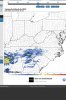
What the most recent HRRR is forecasting in just a couple of hours ... vs what’s actually happening ... significant differenceWhat? Lol
It’s not perfect but its not that far off.
https://www.pivotalweather.com/model.php?rh=2019021912&fh=0&dpdt=&mc=&r=conus&p=refcmp&m=hrrr
Also the band if anyone is watching on radar is not weakening at all ... theres even redevelopment happening near Atlanta and precip rates have looked good too
What the most recent HRRR is forecasting in just a couple of hours ... vs what’s actually happening ... significant difference


That’s the most recent initilization ... that also has everything falling apart an hour or so after .. earlier runs (last night and even this morning) didn’t show it at all! Wow it’s really playing catch up
.png")
.png")

Duh, the HRRR is supposed to be close to reality at initialization but the point you're clearly missing here is that the 2-3 hour forecasts this poster is referring to were in fact pretty abysmal w/ this band of precipitation.
9z HRRR 3 hr forecast was a joke.
View attachment 15967
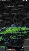
Reality:
View attachment 15968
Yep, can see it with 925mb analysis View attachment 15970
What is still crazy to me is the models haven’t picked up on this band of precip that’s still moving in ... they don’t have widespread precip like that over spreading until later this afternoon... biggest wildcard imo
Here was his first post that I commented on.
Clearly the hrrr initialized with the band so it is picking it up.
Lol

Radar is pretty impressive right now and showing no signs of falling apart even for areas in SC/NC. At this point this is more of a nowcast type of scenario with the models handling the qpf so poorly.
View attachment 15971
Yes but the previous 2-3 hour forecasts were virtually crap so your point is effectively mute.
It's been my experience over the years that weak overrunning events like this are often poorly modeled in regards to qpf placement and strength. This looks like it may be a similar scenario where models aren't handling the precip all that well. This is key because if the initial band is stronger/heavier than modeled in places like NC there might be a quick burst of snow/sleet whereas the models that form the band to the north of NC delay the precip too long. Based on ground observations and radar I would lean right now to the idea of a quicker arrival of precip with a better chance for some brief snow/ice before WAA takes over and changes areas to rain or zr in the CAD areas.


Agree.... like the images posting earlier.A useful resource for tracking this storm is the SPC mesoscale analysis page. For this storm the 850mb and 925mb layers will be useful in tracking things in NC. I find the 925mb layer usually shows up the CAD pretty well and you can already see the beginning stages of it forming in Western NC. The 700mb layer is a good one to look at as sometimes a warm nose can show up here and also to see what the RH is.


Were you forecast to get rain today or was it supposed to hold off until tonight? We are supposed to be dry until after 8:00 pm. There's that little batch to the south, but I'm not sure it holds together long enough to move in here.Pouring rain here now. Take lots of pictures when the sleet starts to fall. It doesn’t last long


You can crop the picture and it will be fine for the server after u crop it down someReceived some unexpected light sleet accumulations overnight in N AL. I'd post an image but it's too large for the server.