BHS1975
Member
I say if someone starts a thread on something that fails they get banned for 2 weeks.
Sent from my iPhone using Tapatalk
Sent from my iPhone using Tapatalk
This will be the one. I will start the threadLol, cmc shows a winter storm at hour 204, are we ever gonna get a damn winter storm under hour 144, I’m actually heated
Yes. We live in the south.One more question is anyone concerned by lack of cold air?
Sent from my iPhone using Tapatalk
FailbruaryHow about F February? Kinda goes with the mood for most.
Sent from my iPhone using Tapatalk
Lol, cmc shows a winter storm at hour 204, are we ever gonna get a damn winter storm under hour 144, I’m actually heated
")
February - WE HAVE NO CLUEFailbruary
Sent from my SM-G955U using Tapatalk
Serious question: Are you going back and reading post? Do you even read all of the post, have you figured out those that really know what they are talking about and make sure you read those post? @Rain Cold made a great post earlier this morning about several different ways we could get cold air for this system or none at all, valuable stuff..... worth the readOne more question is anyone concerned by lack of cold air?
Sent from my iPhone using Tapatalk

SMDHIf the models still look good tomorrow, i'm starting a thread for the Jan 30 system.
If the models still look good tomorrow, i'm starting a thread for the Jan 30 system.
Don’t worry. Those temps will verify 8 degrees warmer.This belongs in here!View attachment 12319
You might want to check out your inbox and notifications sometime ya knowThis belongs in here!View attachment 12319
No. We will create a new one. New storm new thread. If this one has legs too we will make a second thread and have 2 storm threads. The prophecy states that LOL. We gotta keep to our word we spoke of.How about we just rename the 1/26-1/28 storm thread for the storm CMC is showing at 204hr. Then when that fails we will rename that one for our first dud we track in 2020?
Anyone know of any decent comparisons between this potential storm and the 2/12/10 storm? I know models had it suppressed but how far out was it suppressed on models? and also, more importantly, how much of a issue was temperatures leading up to that storm? Because in Columbia, I don't ever remember that being an issue. I remember them saying it could briefly start as rain and then go to snow but it started as snow and ended as snow.
Anyone know of any decent comparisons between this potential storm and the 2/12/10 storm? I know models had it suppressed but how far out was it suppressed on models? and also, more importantly, how much of a issue was temperatures leading up to that storm? Because in Columbia, I don't ever remember that being an issue. I remember them saying it could briefly start as rain and then go to snow but it started as snow and ended as snow.
Can you please move to Canada? I really want snow and I think we have figured out you are the warm nose in the upstate.This belongs in here!View attachment 12319
Pics ?My mud froze
that's easily an inch of frozen mud, congrats!
No joke the GFS is down in Cuba this run. Low develops in the Bahamas.

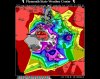
Yeh I remember it was 40 degrees when snow started falling, temps dropped fast after that. Great storm.I would love to see the H5 look, because it'd give me a good idea how similar it is, I've looked at reanalysis maps for that storm (and many storms), but not an H5 map.
Can't look at surface temps when there is no precip though. 850s are fine, and if they were torching, then there would be a problem. I honestly think in that silly hypothetical world where there ended up being no storm back then, we probably would've stayed in the 40s. Shoot I've looked at the hourly history for then, and I was at 37 when precip was just starting. I remember looking up one minute and there was a mix, then looking up a few minutes later and snow started.
Edit: dang, based off that Arcc post, both 500 mb map looks are eerily similar look wise, dun dun dun. If we get a 2/12/10 like storm, I'm perfectly fine with the next look working out for the midsouth, then would be OK if winter didn't work out after that.


I mean it is true. It's crazy such a solution arose and I was pretty much the guy who showed up to the pot luck with a lopsided fruitcake.Man I was reading PBP and everyone was all excited and then I saw where you posted this and I spit my boneless jerk chicken wings out laughing


Good news doesn’t end there. GEFS 12z run for Feb 1 vs what it showed only a couple of days ago.
Some winters it just wants to be warm. Well, most winters lately.
View attachment 12329View attachment 12330
 I envision warmer days ahead