NBAcentel
Member
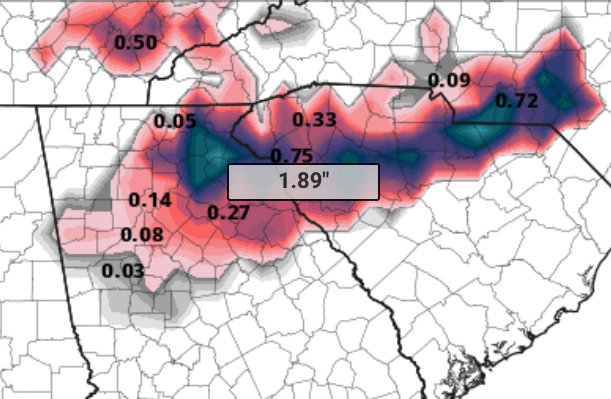
https://www.weather.gov/media/gsp/YouTube/brief.pdf this is the link to their briefing and that lr snow map
When one you like? 18z Euro v/s GFS. GFS a little quicker bringing in precip which is big difference for us central NC folks.
View attachment 8548 View attachment 8549
Late to the party but DAMN! Sorry for the language.
Love how it jumps from 2.8 to 15.9.Here’s a better FV3 map that filters out the ice. Still a huge hit.
View attachment 8540
Lol FV3 has a little finger of foot plus over me now..... rightHere’s a better FV3 map that filters out the ice. Still a huge hit.
View attachment 8540
The Pivotal FV3 map gives nearly 2" of ice to Banks County - that'd be simply horrific.I ain't gonna lie, that run of the FV3 has me a little worried about ice if we keep going trends wise, although the TT maps are obviously clownish and wrong.
I was gonna ask the same thingHow did the 18z Euro look someone??? Stronger ridge I hope.
There is no 18z euro. Just 0z and 12z. Eps is another story thoughHow did the 18z Euro look someone??? Stronger ridge I hope.
Kuchera doesn't really filter out the ice. It just uses the max temp of the column to determine the snowfall ratio (which isn't even necessarily accurate) based off of the liquid equivalent that has fallen. So it still includes IP because model snowfall is SN+IPHere’s a better FV3 map that filters out the ice. Still a huge hit.
View attachment 8540
There is no 18z euro. Just 0z and 12z. Eps is another story though
I see you FV3 lol. Here pivotal's ice accumulations.
Soundings have wintry mix sleet/zr Sunday afternoon/evening then transition to snow Monday.View attachment 8541 View attachment 8543 View attachment 8545
What did the 18z EPS say?
The 18z GEFS is running on pivotal.


Final tally on 18z GFS
Yea dupage here is text for ATL area hr 117 which shows snow on the map in Ga. Surface temps at 3.3C or ~37F and -2.2C at 850mb.I compared the Dupage ptype maps with the weathernerds ptype maps and they are very very different to the South for the core of the event. When I click the area around CAE to generate a sounding on dupage, it gives me temps in the 40s and rain. When I do the same with the weathernerds website, it gives me some coordinates that when reversed show southern SC and says 32.8F and a mix.
Something is not right. Be very careful with the tidbits & weathernerds ptype/accumulation maps.
I get more than Brick!!! Yes!!
Final tally on 18z GFS
Another increase farther south and east in NC.
I can't imagine that verifies for the Atlanta area. But, if it did, it would be as rare as Atlanta winning a championship.
And since I'm going to the MLS Cup on Saturday night (let's go Atlanta United!), maybe this is some weird weather/sports karma, LOL. (Mods, please move to banter if not appropriate for this thread).
--30--
Great read. Even though he isn't talking about other areas, it sounds like there is a good indication the NAM is actually realistic with its setup and the CAD will be strong. I wonder what the mountains would look like after this hits. Maybe snowcover for weeks up there.Ok, the post by the met Hurricane Tracker in the mountain thread on American is too good not to share. Even if you aren't in the crosshairs with this storm, this is absolutely worth the read for every weather enthusiast.
"Hi all. I hear some folks have asked for my take on the current winter storm. Happy to help and participate here when I can and when I think my posts will be informative (rather than just banter or MBY endless posts). So here goes. AND do note - this is for the mountains of WNC only. Sorry other readers.
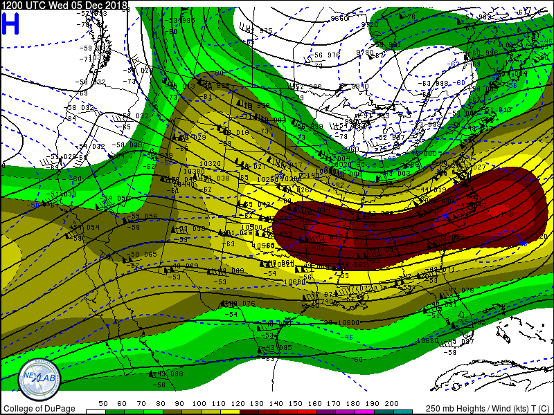
I think most, if not all, of you have the general idea that a big winter storm is on tap. That storm system is currently entering Southern California (which is a great thing for them!). They are in serious drought out that way and every storm system helps. The southern position of the upper level low moving onshore in associated with a strong subtropical jet are two very common characteristics of El Niño. So you will see some folks in the main thread refer to this as an El Niño wave. In El Niño years, the subtropical jet (STJ) flows fast from west to east from SoCal through southern Texas and into the Gulf Coast states. That is exactly what we have here. By Saturday, this jet buckles tremendously as our low gets carved out, with wind speeds greater than 180 knots (almost 200 mph)! This is very intense and only seen with the biggest storm systems in the mid-latitudes. The southeastern states will be under the right entrance region of the jet (a proxy for upward vertical motion).
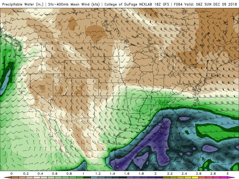
Then we have the full wave at 500mb moving in across the ArkLaTex region at 18Z Saturday. Meanwhile, a strong northern stream wave is forecast to be located over central North Dakota. Over time, the GFS model does not ever phase (I.e., merge) these two waves into one. Instead, the primary wave that comes into California scoots across the Deep South and induces a surface low pressure system near Houston, TX basically first thing Saturday morning. This low draws upon rich and deep gulf moisture (characterized by precipitable water values in excess of 1.40” - incredibly deep for December and sourced from the STJ and eastern Pacific! Wow! By Saturday night and into Sunday morning, this deep moisture is pointed straight at the southern Apps, much like a fire hose but with deep tropical connections. Meanwhile, as the surface cyclone moves into southern Georgia, we have southwest winds aloft but locally we have southeast winds circulating around our low. This in turn brings in a secondary layer of moisture at the surface, combined with deep tropical moisture aloft. I just cannot emphasize how big a deal this tropical fire hose is. Even in spring this would be a big deal (for severe weather/flooding reasons).
The surface low however has other things to work with. A seasonally-strong cold cP (continental-polar) airmass, will be building into the Midwest on Friday and Saturday. In winter, anything over 1040mb is a very cold airmass. This high pressure is basically squeezed east as the STJ buckles and mass evacuation (I.e., air parcels being ejected from the center of the low pressure in Texas), act to strengthen the squeeze (confluence) in the Midwest. Let’s not forget this high will be moving over some snow cover, which acts like a refrigerator. Some models handle the intensity of such highs differently. Regardless, all models take the high into New England and then the cold oozes southwest, hugging the entire Apps Chain all the way to western NC. Enter the wedge. This wedge is sourced from cold air in New England. Wedging is reinforced (I.e., positive feedback loop) by dynamical cooling from precipitation and ageostophic adjustment due to barrier winds. We have all those ingredients here. Southeast winds around the low act to also serve as an “upslope” mechanism, inducing upward vertical motion and enhancing any existing synoptic-scale vertical motions. Oof.
Score one for the NAM here. GFS has been very bad so far this year with wedging air masses (too warm). It has always played catch up while the CMC and RGEM greatly (and I do mean greatly!) overdoes the cold wedge. NAM seems to be the sweet spot (did I just type that?). It has a 1038mb high moving into position during the day Saturday. So, the question is, how cold? Ignoring surface temperatures for the time being, the 850mb temperatures (~5000’) stay below freezing the entire time! The cold is REINFORCED by precipitation and 35 knot southeasterly winds above the surface. Surface temperatures are also below freezing, as a stready wind vector from the NE funnels cool and dry cP air into the storm system, and the forecast soundings (thermal profiles) remain ALL SNOW on the GFS model.
Take a moment and examine the thermal profile I shared here for 7pm Saturday night. Note that very deep isothermal layer (layer of equal temperature...below freezing) from the surface to 700mb. This is a classic WNC heavy duty, paper machete, snow sounding. And I can tell you our thermal profiles stay this way for a while. Oof.
So, let’s review. We have 1) cold high pressure wedging down...check. 2) source of upward vertical motion (double check). 3) moisture? Oh heck yea. CHECK. And this is just the southern stream wave! The northern stream eventually comes down to reinforce the growing trough over the east coast giving us our second punch in the gut.
OK.. now here is where I lay down my personal thoughts having digested and explained it all here. <takes off the gloves>
I want to impart a few things on you guys. Stop looking at the snow maps. They are assuming 10:1 ratios....and just by looking at those soundings, you can absolutely tell it won’t be 10:1 (I am thinking 7:1, based solely on experience). You should be looking at trends in the QPF. And you should NOT look at the QPF from the GFS - why? Because it has been wrong by a factor of 2, and even 3, most of the fall season in western North Carolina! (Not saying it could be right elsewhere, but for now, WNC has been missed badly by the GFS). Here the Euro and NAM models have performed very well in this department. And you gotta think...BIG source of tropical moisture. Plus Atlantic moisture. Plus vertical motion. Plus jet dynamics. When the dynamics are there the moisture will find a way. We are not lacking dynamics. Euro was around 3.00” of liquid equivalent. NAM isn’t out this far yet. GFS was 1.40” (multiply by a factor of 2 and you get 2.80”). Dang! That’s a LOT of liquid. Thermal profiles support snow, and maybe some sleet far southern escarpment as the warm nose tries to invade (briefly).
10:1 ratio gives you 28-30” of snow. Bwa ha ha ha. I can’t do it. Just can’t do it. What did GSP say, “generational” event? You bet.
7:1 ratio still gives 15-18” of cement snow. Oof. Who in their right mind feels good about issuing a forecast like that around here? It’s unheard of. Can it happen? It could. Would I go with these values at day 4 (looking at you WYFF)....no. Why not? Because the atmosphere is always in motion. Things flow like saltwater taffy being pulled from two ends.
And we still have time to watch this. BUT BUT BUT...we have been watching this since Saturday, Dec 1. It is equally mind-boggling to me to think that the large scale pattern and such has been so incredibly consistent for so long! The Weather Prediction Center now has the mountains 70-90% chance of a major winter storm at DAY 4! Wow.
The Euro has a 96% chance of 6” or more from this system. The GEFS mean is creeping up (on QPF...more snow, less sleet/ZR as the wedge is better reflected).
Oh and start time? BANK ON EARLIER rather than later. I have seen this time and time again. These systems break out precipitation along the warm fronts and into the cold dome earlier than most systems. GFS might have this right. Another trend to watch next 2-3 days.
Alright, enough rambling. Hope it’s helpful. TL;DR - get ready. Prepare now for a big snow event with potential for prolonged power outages. This is as big a deal since December 2009. if you live anywhere in the cold air damming favored areas of WNC (sorry Franklin), this storm has your number."
LOL! I'm not sure either. We all love weather, and this is looking to be a once in a generation event for some regions in the SE. We needed to have it here for posterity.@packfan98 I wasn't sure if "cross-posting" was allowed. It is a very good read!
The 5Stripes are appropriate anywhere and everywhere.
They’re are about to flip the script my friend. Incredible team. This will be the first match at home that I’ve missed all year due to the Mrs having an Xmas party to attend. At least this event venue will have the match on & an open bar. I’ll be the guy wearing a penguin suit and a Terminus Legion scarf.
That said, this solution by the FV is a crock. There’s no way this verifies. I can’t see any solution that brings 2M temps below 0C for a long enough period of time to be impactful...some pingers at best...that’s just for ATL proper...for those folks that live in South Forsyth county like my in-laws, it might be different.
Sent from my iPad using Tapatalk


Agreed! I'm in the upstate of SC (Greenville/Pickens county line) and I am cautiously optimistic that this will really turn into the "generational" event!LOL! I'm not sure either. We all love weather, and this is looking to be a once in a generation event for some regions in the SE. We needed to have it here for posterity.
