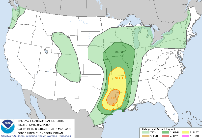
• Hello, please take a minute to check out our awesome content, contributed by the wonderful members of our community. We hope you'll add your own thoughts and opinions by making a free account!

Severe November 5th-6th Severe Weather Threat

At 440 PM CST, a confirmed tornado was located over Belmont or 10
miles northeast of Zwolle, moving east at 30 mph.

HAZARD...Damaging tornado and quarter size hail.

SOURCE...Radar confirmed tornado.
Locations impacted include...
Belmont and Marthaville.
 
Man those storms in Louisiana spinning like a top to be so far south of the forcing aloft. Interesting to see what that means for areas further north

Hard to tell. While the forcing is lower, the shear vector is nearly due west so the linear forcing is lower thus creating a better setup for discrete convection.

The farther north you go and as time passes the linear forcing will increase.
 
The hooks on some of these warned storms on radar have been very impressive tonight!!!
 
Latest from SPC:
...THERE IS AN ENHANCED RISK OF SEVERE THUNDERSTORMS FROM SOUTHEAST
AR TO MIDDLE TN...

...SUMMARY...
Severe storms capable of damaging winds and tornadoes are expected
this evening and overnight across the ArkLaMiss region and Tennessee
Valley.

...Discussion...

Cluster of tornadic supercells that evolved south of SHV late this
afternoon appears to have been influenced by a weak disturbance that
translated across southeast NM into east TX this evening. Surface
parcels ahead of this feature, south of I-20, were uninhibited
shortly after peak heating and discrete storms were able to evolve
ahead of the primary cold front. This activity has waned a bit in
intensity over the last hour or so but should progress across
northeast LA into western MS later this evening.

Latest thinking is convection should gradually increase in areal
coverage across southeast AR over the next few hours and likely to
evolve into a frontal squall line downstream over portions of the TN
Valley/northern Gulf states. 00z soundings from LZK/ULM exhibit a
slightly stable boundary layer, but strongly sheared and adequately
buoyant for deep convection this evening. Damaging winds should
become more common as the frontal convection matures and bow-type
structures evolve. Otherwise, tornadoes remain possible with
supercell structures, both ahead of the line and within the squall
line.

..Darrow.. 11/06/2018
 
Latest HRRR seems to keep the line stronger and more organized further south than previous runs. It will be interesting to see when the line decides to weaken.
 
5 active tornado warnings right now. It’s going to be a long night
 
Looks like we have rotation north of Tupelo. Mantachie is right in the crosshairs
 
NWS dropped the ball on that tornado warning. Clear couplet on radar but wasn’t warned until it was on the ground. Not sure how much it matters when most people are asleep anyway. Hopefully people are ok
 
Man there’s just too much happening right now to even track. Grief. Good luck everybody
 
Not bad here at all just gusty wind and that was ahead of the storms... going to bed glad it wasn't too bad
 
Any thoughts on how bad of a threat we will have today?
 
I know what the SPC has. They show the slight and marginal threat, which is silly and really the same thing. I was just wondering about other's opinions. Doesn't seem to be a lot of talk about it.
I think the threat is marginal for our area and the "slight" has moved to the NE. Did you read their discussion and Raleigh's? It doesn't look all that favorable for widespread severe hear. That's probably why there isn't a lot of talk about it.
 
It just came a damn monsoon at my house. I’ve never seen the bottom fall out like that. And the wind ahead of that line! Let’s do it again
 
I think the threat is marginal for our area and the "slight" has moved to the NE. Did you read their discussion and Raleigh's? It doesn't look all that favorable for widespread severe hear. That's probably why there isn't a lot of talk about it.
Looks like SPC has now shifted the slight area back SW a little to include portions of NE NC, including mby.... Rah NWS needs to update their graphics
day1otlk_1300.gif
 
I don't think it really matters. Slight and marginal are really the same thing in my mind.
 
Just as enhanced and moderate are really not that different. They should just have a scale of 1 to 3.
 
I never really understood why the hype for AL on this started so early. These systems generally wind up with the main energy way too far north. It is more of NW Ms, W Tn, Ky threat generally.
 
Just as enhanced and moderate are really not that different. They should just have a scale of 1 to 3.
They have 5 categories for hurricanes. And they don't even give them clever names.
 
75 and the sun is peeking out a little bit here. RAH has the line of storms coming through between 6 and 7 this evening.
 
75 and the sun is peeking out a little bit here. RAH has the line of storms coming through between 6 and 7 this evening.
SBCAPE has been on the increase especially US 1 eastward, so I'd say a severe storm or two may not be out of the question
 
A line is already coming through now. Seems a lot earlier than predicted. Probably will cause the instability to weaken.
 
Unfortunately one woman lost her life last night in Christiana Tennessee when an EF2 tornado touched down and ripped the house off the foundation. Looks like the worst of it was south of Nashville last Night. As I stated I was under a tornado warning but luckily it never touched down.
 
Back
Top