Flood Watch
National Weather Service Peachtree City GA
320 PM EDT Sun May 27 2018
GAZ005>009-012>016-019>025-027-030>039-041>062-066>073-078>082-
089>094-102>104-281000-
/O.NEW.KFFC.FF.A.0004.180528T1500Z-180530T0000Z/
/00000.0.ER.000000T0000Z.000000T0000Z.000000T0000Z.OO/
Murray-Fannin-Gilmer-Union-Towns-Gordon-Pickens-Dawson-Lumpkin-
White-Floyd-Bartow-Cherokee-Forsyth-Hall-Banks-Jackson-Madison-
Polk-Paulding-Cobb-North Fulton-Gwinnett-Barrow-Clarke-Oconee-
Oglethorpe-Wilkes-Haralson-Carroll-Douglas-South Fulton-DeKalb-
Rockdale-Walton-Newton-Morgan-Greene-Taliaferro-Heard-Coweta-
Fayette-Clayton-Spalding-Henry-Butts-Jasper-Putnam-Hancock-Warren-
Troup-Meriwether-Pike-Upson-Lamar-Monroe-Jones-Baldwin-Harris-
Talbot-Taylor-Crawford-Bibb-Muscogee-Chattahoochee-Marion-Schley-
Macon-Peach-Stewart-Webster-Sumter-
Including the cities of Calhoun, Dahlonega, Cleveland, Rome,
Cartersville, Gainesville, Marietta, Atlanta, Lawrenceville,
Athens, Carrollton, Douglasville, East Point, Decatur, Conyers,
Covington, Newnan, Peachtree City, Griffin, Milledgeville, Macon,
Columbus, Lumpkin, and Americus
320 PM EDT Sun May 27 2018
...FLASH FLOOD WATCH IN EFFECT FROM MONDAY MORNING THROUGH
TUESDAY EVENING...
The National Weather Service in Peachtree City has issued a
* Flash Flood Watch for portions of central Georgia...east
central Georgia...north central Georgia...northeast Georgia...
northwest Georgia and west central Georgia...including the
following areas...in central Georgia...Baldwin...Bibb...
Butts...Crawford...Jasper...Jones...Monroe...Peach and Putnam.
In east central Georgia...Greene...Hancock...Taliaferro...
Warren and Wilkes. In north central Georgia...Barrow...
Cherokee...Clayton...Cobb...Dawson...DeKalb...Douglas...
Fannin...Fayette...Forsyth...Gilmer...Gwinnett...Hall...
Henry...Lumpkin...Morgan...Newton...North Fulton...Pickens...
Rockdale...South Fulton...Union and Walton. In northeast
Georgia...Banks...Clarke...Jackson...Madison...Oconee...
Oglethorpe...Towns and White. In northwest Georgia...Bartow...
Carroll...Floyd...Gordon...Haralson...Murray...Paulding and
Polk. In west central Georgia...Chattahoochee...Coweta...
Harris...Heard...Lamar...Macon...Marion...Meriwether...
Muscogee...Pike...Schley...Spalding...Stewart...Sumter...
Talbot...Taylor...Troup...Upson and Webster.
* From Monday morning through Tuesday evening
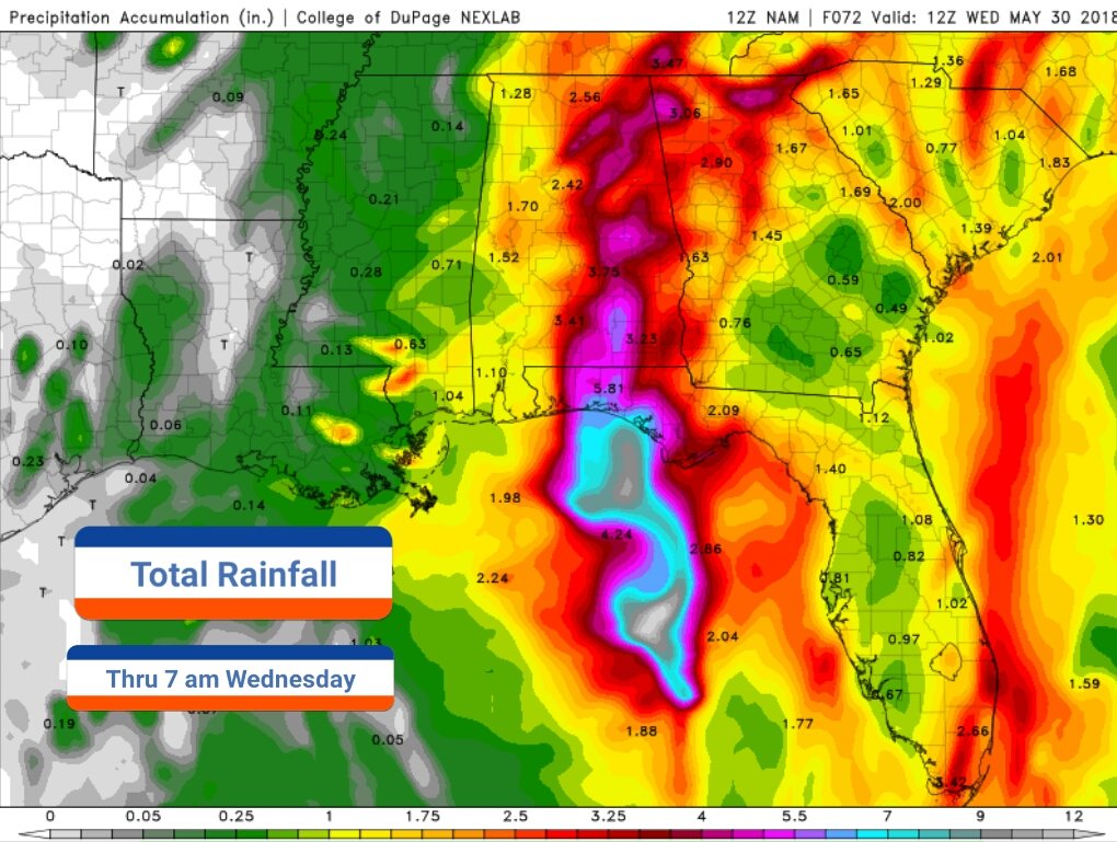
* Subtropical storm Alberto will progress northward through the
Florida Panhandle and Alabama through Monday evening bringing
abundant moisture along and east of its track. This will allow
for increased rainfall potential across the local area. Although
average rainfall totals across the entire watch will only
average 2 to 3 inches, banded precipitation could lead to some
areas receiving as much as 4 to 5 inches through Tuesday. These
rainfall amounts may lead to flash flooding across the area as
well as some river and small creek flooding.
PRECAUTIONARY/PREPAREDNESS ACTIONS...
A Flash Flood Watch means that conditions may develop that lead
to flash flooding. Flash flooding is a very dangerous situation.
You should monitor later forecasts and be prepared to take action
should Flash Flood Warnings be issued.
&&
$$