Yellow Snow
Member
NHC now has a 60% chance thru 5 days...
https://www.nhc.noaa.gov/gtwo.php?basin=atlc&fdays=5
https://www.nhc.noaa.gov/gtwo.php?basin=atlc&fdays=5
000
ABNT20 KNHC 231153 CCA
TWOAT
Special Tropical Weather Outlook...Corrected
NWS National Hurricane Center Miami FL
800 AM EDT Wed May 23 2018
Corrected header
For the North Atlantic...Caribbean Sea and the Gulf of Mexico:
A broad surface low centered near the coast of northeastern Belize
continues to produce a large area of cloudiness and showers
extending from the northwestern Caribbean Sea across Cuba and into
the Florida Straits. Little development is expected during the
next couple of days due to strong upper-level winds and proximity to
the Yucatan Peninsula. However, environmental conditions are then
forecast to become more conducive for development, and a subtropical
or tropical depression could form this weekend over the eastern or
central Gulf of Mexico. Regardless of development, locally heavy
rainfall is possible across western Cuba and the Cayman Islands
during the next few days, and over much of Florida and the
northern Gulf Coast during the weekend. For more information on the
heavy rain threat, please see products issued by your local weather
office. The next Special Tropical Weather Outlook on this system
will be issued by 800 PM EDT.
* Formation chance through 48 hours...low...near 0 percent.
* Formation chance through 5 days...medium...60 percent.
$$
Forecaster Blake


In partial deference to the models, I'm currently still near a respectable 1 in 3 chance for a TD to form this week though now I'm thinking in the GOM if it occurs, which is quite high for that area in late May based on history, but still only near a 5% chance for a subsequent FL TS hit. So, I'm saying that IF a TD forms this week, there's about a 1 in 6 chance for that TD to hit FL as a TS before the month is out. That's how I get my 5% FL TS hit chance. I'm at a 10% chance for an actual TS hit anywhere along the US Gulf coast by the end of May.
Regardless, heavy rain in parts of the SE is currently the biggest threat assuming slow movement. For some areas, this system could be a blessing even if there is heavy rain (assuming no flooding in those areas).
The SD and RC rain shield is flexing it's musclesLooks like less precip getting into the Carolinas from this, with this mornings guidance. Was a lot of areas with 3-5” 7 day totals, today, mostly 1-2” amounts
Larry,In deference to non-GFS models persisting with genesis of either a TC or a STC after a couple of days (genesis time coming in closer despite it being only late May) and also considering satellite trends, I'm raising the chance for a GOM genesis of either a TD or a STD to 50%. In concert with this, I'm also raising the chance for either a TS or a STS landfall anywhere on the Gulf Coast to a 1 in 3 chance. In other words, I'm now at a 2 out of 3 chance for a TS/STS landfall IF there is a TD/STD genesis. I'm still at only a 10% chance for a TS/STS landfall on FL. This is based on seeing SSTs that are plenty warm enough to sustain a TS/STS all the way to the coast but moreso west of the FL Panhandle. I'm at only a 5% chance that this will ever be a H and am only at a 1% chance for this to landfall as a H somewhere on the Gulf coast.


Happy Memorial Day indeed.Happy memorial day from the 12z Euro
Sent from my SM-J327VPP using Tapatalk


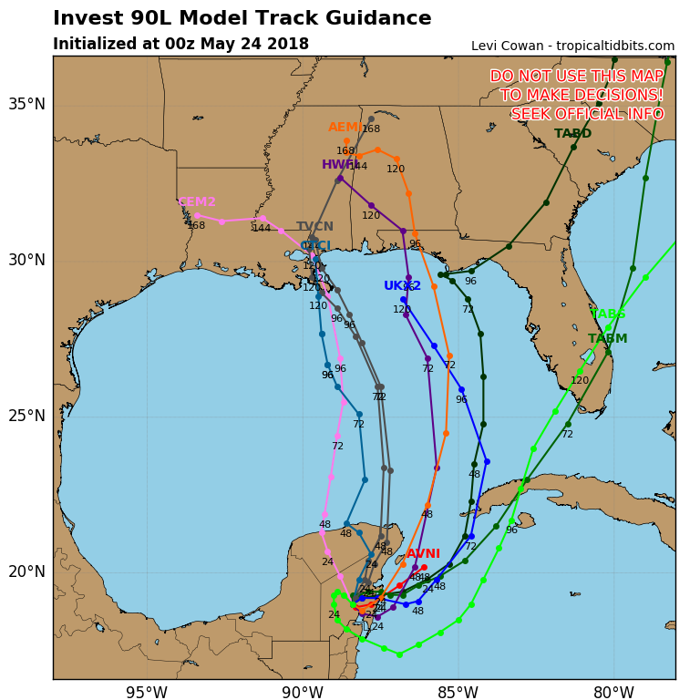
Yeah, this one should be at least a depression. The models stand at this:Code Red!
A broad surface low centered over the southeastern Yucatan
Peninsula has become better defined since yesterday, and it
continues to produce a large area of cloudiness and showers
extending from the northwestern Caribbean Sea across Cuba into the
Florida Straits. Continued slow development of this system is
possible during the next couple of days as it drifts northward near
the Yucatan Peninsula. Thereafter, environmental conditions are
forecast to become more conducive for development, and a subtropical
or tropical depression is likely to form this weekend over the
eastern or central Gulf of Mexico. Regardless of development,
locally heavy rainfall is possible across western Cuba and the
Cayman Islands during the next few days, and over much of Florida
and the northern Gulf Coast during the weekend. For more information
on the heavy rain threat, please see products issued by your local
weather office. The next Special Tropical Weather Outlook on this
system will be issued by 800 AM EDT on Thursday.
* Formation chance through 48 hours...low...10 percent.
* Formation chance through 5 days...high...70 percent.
You left out the N.C. rain hole over Raleigh, that we know is on the map!Happy memorial day from the 12z Euro
Sent from my SM-J327VPP using Tapatalk
Trying to help you out . Can't be upset with something you don't see lolYou left out the N.C. rain hole over Raleigh, that we know is on the map!