-
Hello, please take a minute to check out our awesome content, contributed by the wonderful members of our community. We hope you'll add your own thoughts and opinions by making a free account!
You are using an out of date browser. It may not display this or other websites correctly.
You should upgrade or use an alternative browser.
You should upgrade or use an alternative browser.
Tropical Subtropical Storm Alberto
- Thread starter stormcentral
- Start date

Won't do it much good by then
Sent from my SM-J327VPP using Tapatalk
Shear suppose to drop end of week
Sent from my SM-J327VPP using Tapatalk
ForsythSnow
Moderator
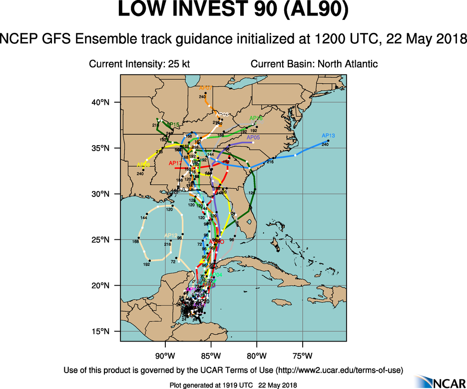
Officially designated an invest now.
pcbjr
Member
Officially designated an invest now.

http://rammb.cira.colostate.edu/pro...ding_image=2018AL90_1KMSRVIS_201805212145.GIF

Last edited:
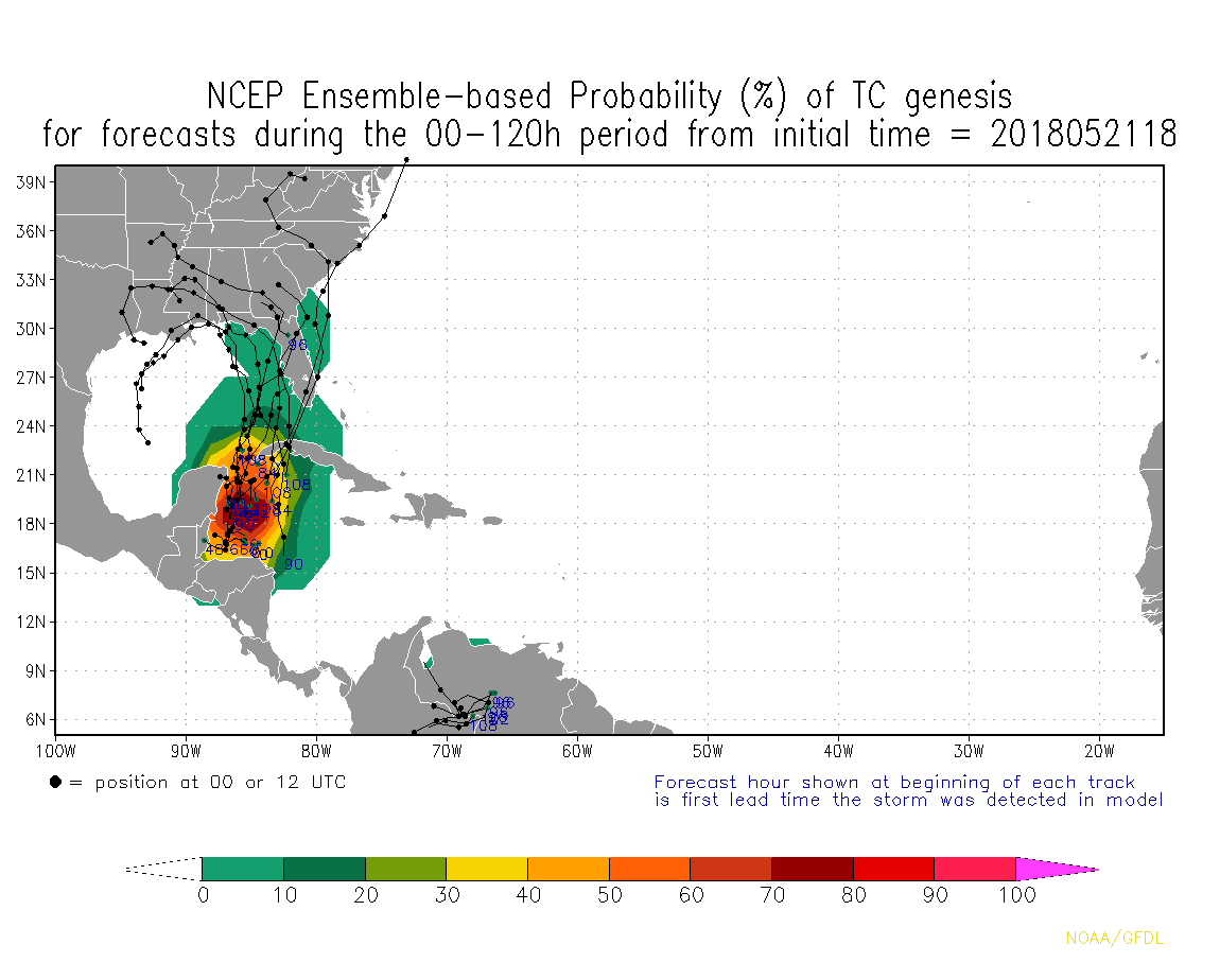
First invest of the season.
5-day chances increased to 40%.
5-day chances increased to 40%.
000
ABNT20 KNHC 212331
TWOAT
Special Tropical Weather Outlook
NWS National Hurricane Center Miami FL
730 PM EDT Mon May 21 2018
For the North Atlantic...Caribbean Sea and the Gulf of Mexico:
A broad surface low pressure area has formed over the northwestern
Caribbean Sea a couple of hundred miles east of the coast of Belize.
This low and an upper-level trough are producing widespread
cloudiness and showers extending from the northwestern Caribbean
Sea across Cuba and the Florida peninsula. While environmental
conditions are expected to be unfavorable for development during
the next couple of days, some gradual subtropical or tropical
development is possible later this week while the system moves
slowly northward into the central or eastern Gulf of Mexico.
Regardless of development, locally heavy rainfall is possible
across western Cuba and much of Florida during the next several
days. For more information on the heavy rain threat, please see
products issued by your local weather office. The next Special
Tropical Weather Outlook on this system will be issued by 800 AM
EDT on Tuesday.
* Formation chance through 48 hours...low...near 0 percent.
* Formation chance through 5 days...medium...40 percent.
$$
Forecaster Cangialosi
The new GFS FV3 made me dizzy at all of the swirls moving around through 18Z
and welcome to history...Good Morning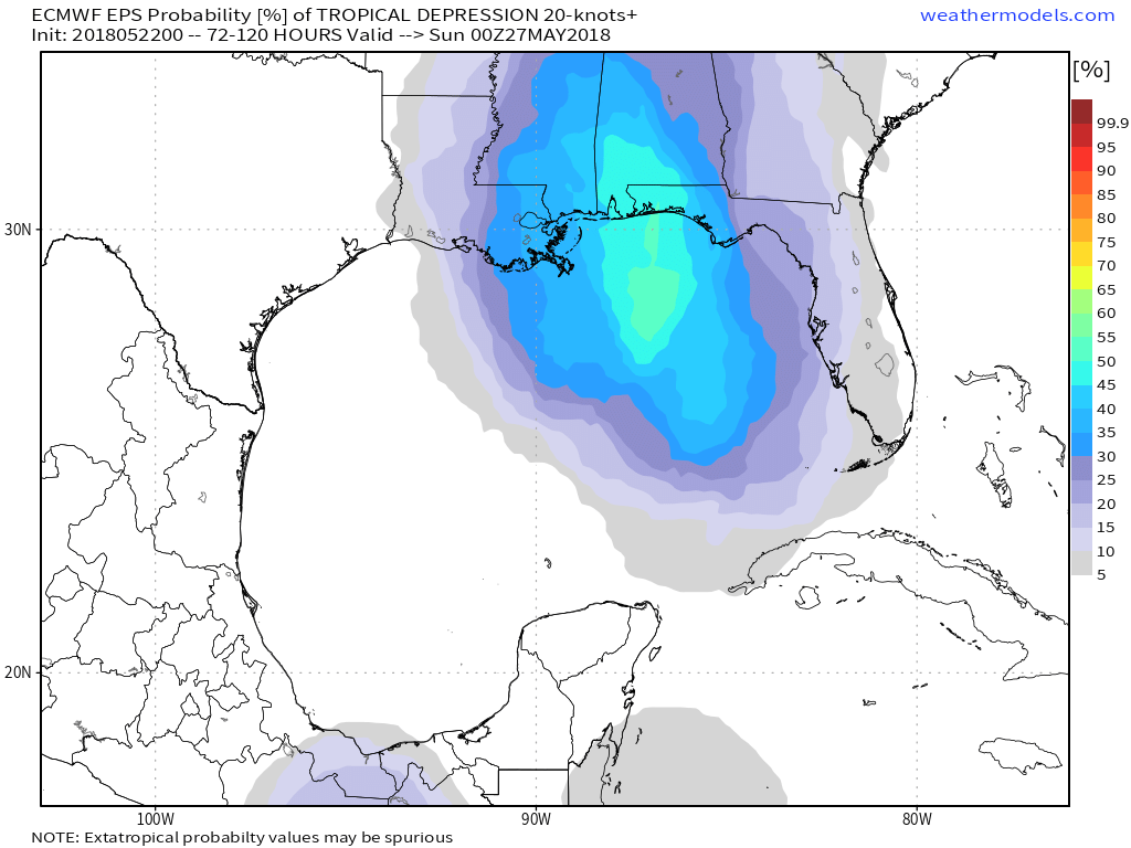
DadOfJax
Member
Hopefully this will bring much needed rain to east AL. The lack of rain over the last week has been nothing short of pathetic. Almost as pathetic as the local forecasts that called for it.
5-day chances remain at 40%.
000
ABNT20 KNHC 221144
TWOAT
Special Tropical Weather Outlook
NWS National Hurricane Center Miami FL
745 AM EDT Tue May 22 2018
For the North Atlantic...Caribbean Sea and the Gulf of Mexico:
A broad surface low centered just east of Belize is producing a
large area of cloudiness and showers extending from the northwestern
Caribbean Sea across Cuba into the Florida peninsula. While strong
upper-level winds and dry air aloft are expected to limit
organization during the next couple of days, some gradual
subtropical or tropical development is possible late this week while
the system moves slowly northward into the central or eastern Gulf
of Mexico. Regardless of development, locally heavy rainfall is
possible across western Cuba, the Cayman Islands, and much of
Florida during the next several days. For more information on the
heavy rain threat, please see products issued by your local weather
office. The next Special Tropical Weather Outlook on this system
will be issued by 800 PM EDT.
* Formation chance through 48 hours...low...near 0 percent.
* Formation chance through 5 days...medium...40 percent.
$$
Forecaster Blake
NCSNOW
Member
- Joined
- Dec 2, 2016
- Messages
- 9,184
- Reaction score
- 18,028
TAMPA BAY WEATHER
0
0
0
0


Forecast: Potential tropical system threatens to drench already soggy Tampa Bay area

[National Hurricane Center]

By Devin Rodriguez, Times Staff Writer
Published: May 22, 2018
Updated: May 22, 2018 at 09:02 AM
Flood warnings have been extended for the Alafia River in Lithia and the Little Manatee River at Wimauma as the National Weather Service continues to monitor a broad area of low pressure that has a building chance of developing into a tropical system.
And with more rain expected the next few days, even more rivers could be at risk, forecasters said.
The area of low pressure is drifting in the northwest Caribbean and could develop tropical conditions while it travels into the Gulf of Mexico by the end of the week, according to the National Hurricane Center. Forecasters place the chance of development around 40 percent in the next five days.
But even if it did not develop into a tropical system, an already drenched region can expect even more showers and thunderstorms.
RELATED: Less than one year after historic flooding, Alafia River spills its banks again
"At best, it will be spreading a lot of rain our way by the end of the week," said Paul Close, a meteorologist for the National Weather Service.. "Most of the rain will fall on Friday and Saturday, it’s possible to continue into Sunday."
Close said this weekend will be very cloudy with off-and-on rain that will be very heavy in some areas.
According to Close, the gulf waters are not warm enough for a low-pressure system to sustain tropical conditions. Chances for development will be higher later in the year when Gulf waters warm over the summer.
But, Close warns, flooding could be a significant problem this week.
"Flooding will be a problem in general, especially urban flooding and low-lying areas," Close said. "We’ve had two or three days last week where we had 2-3 inches of rain within a few hours that flooded roads. That could happen this weekend."
A flood warning remains in effect for the Alafia River until Wednesday night. Flood stage is 13 feet, but as of Monday night at 9 p.m., it had reached 14.2 feet and is expected to rise to 14.5 feet on Tuesday before subsiding Wednesday afternoon.
The Manatee River reached 11½ feet Monday night, a half-foot above flood stage.
EXTENDED FORECAST: The 10-day outlook for the Tampa Bay area
Over the next two days, the Tampa Bay area will see that familiar summertime rain pattern of scattered showers and thunderstorms firing up primarily in the afternoon, forecasters said.
Tuesday morning temperatures sit in the low 70s with a lot of high humidity. By the afternoon, temperatures will rise to around 86 with a 60 percent chance of rain.
High rain fall has caused some minor flooding in the area and caused four sinkholes to form at the Villages retirement community in Central Florida.
As the week grinds on, folks should plan their morning and evening commutes with rain in mind. Rain chances will be at 60 percent throughout the week, and Memorial Day weekend could be a washout, forecasters said.
730 PM Special Tropical Weather Outlook. Medium chance (40%) of development of a broad low pressure system is possible late this week over the central or eastern Gulf of Mexico. Locally heavy rainfall is the main threat across western Cuba & Florida during the next several days. pic.twitter.com/YOxqiGDPhf
— NHC Atlantic Ops (@NHC_Atlantic) May 22, 2018
0
0
0
0
Forecast: Potential tropical system threatens to drench already soggy Tampa Bay area

[National Hurricane Center]

By Devin Rodriguez, Times Staff Writer
Published: May 22, 2018
Updated: May 22, 2018 at 09:02 AM
Flood warnings have been extended for the Alafia River in Lithia and the Little Manatee River at Wimauma as the National Weather Service continues to monitor a broad area of low pressure that has a building chance of developing into a tropical system.
And with more rain expected the next few days, even more rivers could be at risk, forecasters said.
The area of low pressure is drifting in the northwest Caribbean and could develop tropical conditions while it travels into the Gulf of Mexico by the end of the week, according to the National Hurricane Center. Forecasters place the chance of development around 40 percent in the next five days.
But even if it did not develop into a tropical system, an already drenched region can expect even more showers and thunderstorms.
RELATED: Less than one year after historic flooding, Alafia River spills its banks again
"At best, it will be spreading a lot of rain our way by the end of the week," said Paul Close, a meteorologist for the National Weather Service.. "Most of the rain will fall on Friday and Saturday, it’s possible to continue into Sunday."
Close said this weekend will be very cloudy with off-and-on rain that will be very heavy in some areas.
According to Close, the gulf waters are not warm enough for a low-pressure system to sustain tropical conditions. Chances for development will be higher later in the year when Gulf waters warm over the summer.
But, Close warns, flooding could be a significant problem this week.
"Flooding will be a problem in general, especially urban flooding and low-lying areas," Close said. "We’ve had two or three days last week where we had 2-3 inches of rain within a few hours that flooded roads. That could happen this weekend."
A flood warning remains in effect for the Alafia River until Wednesday night. Flood stage is 13 feet, but as of Monday night at 9 p.m., it had reached 14.2 feet and is expected to rise to 14.5 feet on Tuesday before subsiding Wednesday afternoon.
The Manatee River reached 11½ feet Monday night, a half-foot above flood stage.
EXTENDED FORECAST: The 10-day outlook for the Tampa Bay area
Over the next two days, the Tampa Bay area will see that familiar summertime rain pattern of scattered showers and thunderstorms firing up primarily in the afternoon, forecasters said.
Tuesday morning temperatures sit in the low 70s with a lot of high humidity. By the afternoon, temperatures will rise to around 86 with a 60 percent chance of rain.
High rain fall has caused some minor flooding in the area and caused four sinkholes to form at the Villages retirement community in Central Florida.
As the week grinds on, folks should plan their morning and evening commutes with rain in mind. Rain chances will be at 60 percent throughout the week, and Memorial Day weekend could be a washout, forecasters said.
730 PM Special Tropical Weather Outlook. Medium chance (40%) of development of a broad low pressure system is possible late this week over the central or eastern Gulf of Mexico. Locally heavy rainfall is the main threat across western Cuba & Florida during the next several days. pic.twitter.com/YOxqiGDPhf
— NHC Atlantic Ops (@NHC_Atlantic) May 22, 2018
In partial deference to the models, I'm currently still near a respectable 1 in 3 chance for a TD to form this week though now I'm thinking in the GOM if it occurs, which is quite high for that area in late May based on history, but still only near a 5% chance for a subsequent FL TS hit. So, I'm saying that IF a TD forms this week, there's about a 1 in 6 chance for that TD to hit FL as a TS before the month is out. That's how I get my 5% FL TS hit chance. I'm at a 10% chance for an actual TS hit anywhere along the US Gulf coast by the end of May.
Regardless, heavy rain in parts of the SE is currently the biggest threat assuming slow movement. For some areas, this system could be a blessing even if there is heavy rain (assuming no flooding in those areas).
Regardless, heavy rain in parts of the SE is currently the biggest threat assuming slow movement. For some areas, this system could be a blessing even if there is heavy rain (assuming no flooding in those areas).
Last edited:


000
ABNT20 KNHC 222314
TWOAT
Special Tropical Weather Outlook
NWS National Hurricane Center Miami FL
715 PM EDT Tue May 22 2018
For the North Atlantic...Caribbean Sea and the Gulf of Mexico:
A broad surface low centered just east of Belize is producing a
large area of cloudiness and showers extending from the northwestern
Caribbean Sea across Cuba and into the Florida peninsula. Little
development is expected during the next couple of days due to strong
upper-level winds and proximity to the Yucatan Peninsula of Mexico.
However, gradual subtropical or tropical development is possible
late this week while the system moves slowly into the central or
eastern Gulf of Mexico. Regardless of development, locally heavy
rainfall is possible across western Cuba, the Cayman Islands, and
much of Florida during the next several days. For more information
on the heavy rain threat, please see products issued by your local
weather office. The next Special Tropical Weather Outlook on this
system will be issued by 800 AM EDT on Wednesday.
* Formation chance through 48 hours...low...near 0 percent.
* Formation chance through 5 days...medium...50 percent.
$$
Forecaster Beven