-
Hello, please take a minute to check out our awesome content, contributed by the wonderful members of our community. We hope you'll add your own thoughts and opinions by making a free account!
You are using an out of date browser. It may not display this or other websites correctly.
You should upgrade or use an alternative browser.
You should upgrade or use an alternative browser.
Tropical Subtropical Storm Alberto
- Thread starter stormcentral
- Start date

000
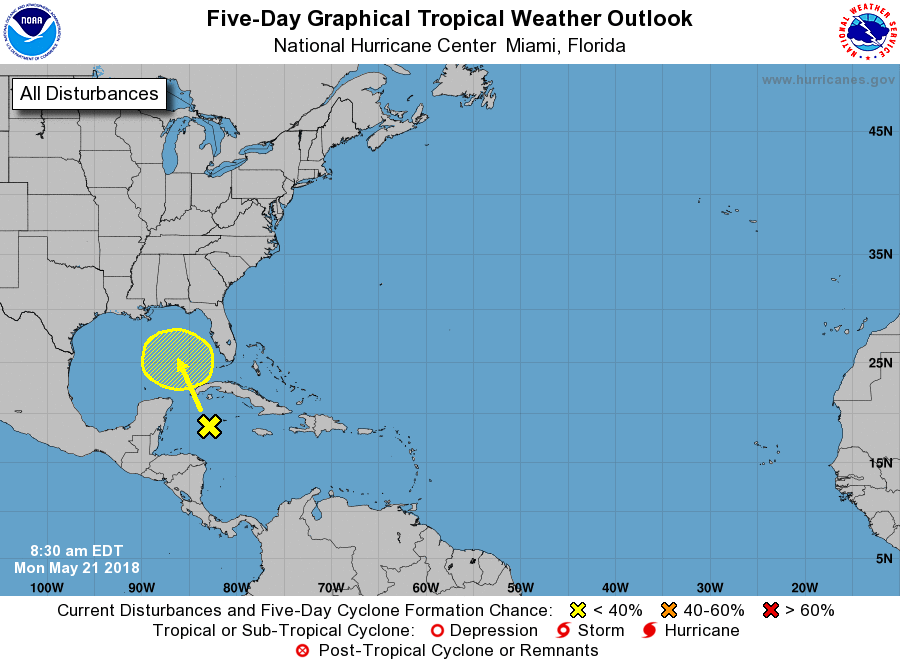
ABNT20 KNHC 211230
TWOAT
Special Tropical Weather Outlook
NWS National Hurricane Center Miami FL
830 AM EDT Mon May 21 2018
For the North Atlantic...Caribbean Sea and the Gulf of Mexico:
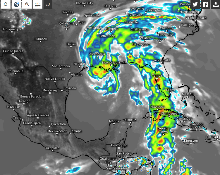
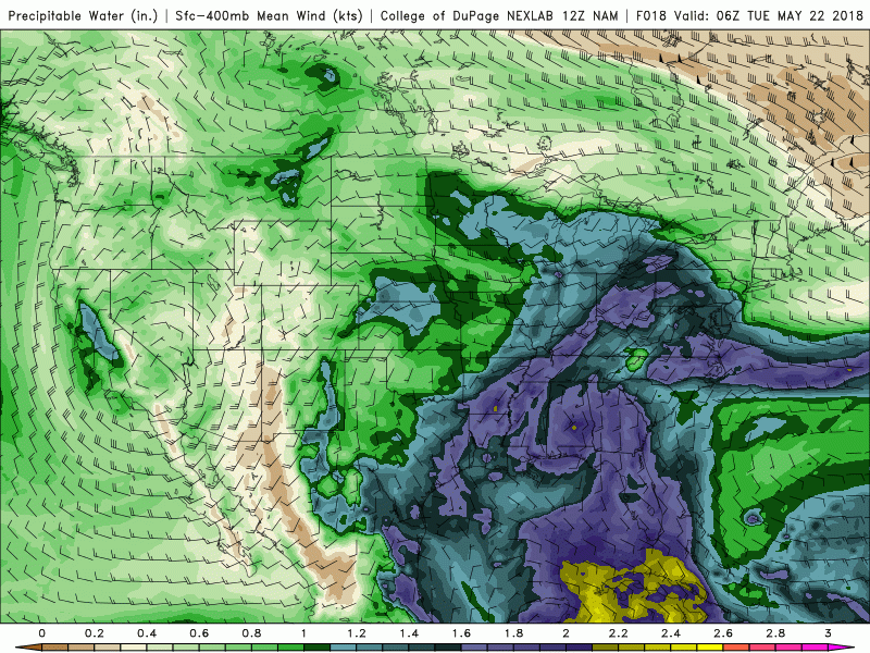
Widespread cloudiness and showers extending from the northwestern
Caribbean Sea across Cuba and the Florida peninsula are associated
with the interaction of a large upper-level low with a weak surface
trough. While environmental conditions are expected to be
unfavorable for development during the next couple of days, some
gradual development is possible later this week while the system
moves into the central or eastern Gulf of Mexico. Regardless of
development, locally heavy rainfall is possible across western Cuba
and Florida over the next several days. For more information on
the heavy rain threat, please see products issued by your local
weather office. The next Special Tropical Weather Outlook on this
system will be issued by 800 PM EDT tonight.
* Formation chance through 48 hours...low...near 0 percent.
* Formation chance through 5 days...low...20 percent.
$$
Forecaster Blake
ABNT20 KNHC 211230
TWOAT
Special Tropical Weather Outlook
NWS National Hurricane Center Miami FL
830 AM EDT Mon May 21 2018
For the North Atlantic...Caribbean Sea and the Gulf of Mexico:
Widespread cloudiness and showers extending from the northwestern
Caribbean Sea across Cuba and the Florida peninsula are associated
with the interaction of a large upper-level low with a weak surface
trough. While environmental conditions are expected to be
unfavorable for development during the next couple of days, some
gradual development is possible later this week while the system
moves into the central or eastern Gulf of Mexico. Regardless of
development, locally heavy rainfall is possible across western Cuba
and Florida over the next several days. For more information on
the heavy rain threat, please see products issued by your local
weather office. The next Special Tropical Weather Outlook on this
system will be issued by 800 PM EDT tonight.
* Formation chance through 48 hours...low...near 0 percent.
* Formation chance through 5 days...low...20 percent.
$$
Forecaster Blake
accu35
Member
- Joined
- Jan 5, 2017
- Messages
- 8,278
- Reaction score
- 9,645
20% to be on the safe side for now.000
ABNT20 KNHC 211230
TWOAT
Special Tropical Weather Outlook
NWS National Hurricane Center Miami FL
830 AM EDT Mon May 21 2018
For the North Atlantic...Caribbean Sea and the Gulf of Mexico:
Widespread cloudiness and showers extending from the northwestern
Caribbean Sea across Cuba and the Florida peninsula are associated
with the interaction of a large upper-level low with a weak surface
trough. While environmental conditions are expected to be
unfavorable for development during the next couple of days, some
gradual development is possible later this week while the system
moves into the central or eastern Gulf of Mexico. Regardless of
development, locally heavy rainfall is possible across western Cuba
and Florida over the next several days. For more information on
the heavy rain threat, please see products issued by your local
weather office. The next Special Tropical Weather Outlook on this
system will be issued by 800 PM EDT tonight.
* Formation chance through 48 hours...low...near 0 percent.
* Formation chance through 5 days...low...20 percent.
$$
Forecaster Blake
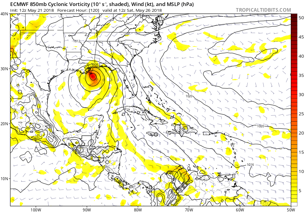
Regardless of the MJO, which JB is emphasizing is favorable for tropical development in the W Caribbean or GOM:
Based on the combination of longterm late May climo and there currently being nothing well organized, nobody should be surprised if no TS were to come out of this. Keep in mind that there have been only 5 TS that had a genesis during 5/21-31 in the W Car/GOM in 167 years. I'm sure the MJO was favorable in many of the years that ended up with no development when we're talking about this many years of climo. I'm still at a 33% chance of TD genesis for now (which is very high for late May) and a 5% chance of a FL TS landfall (also very high for late May). I'll adjust these up or down as we move forward. There could just as easily be no more than a very broad low that never gets past the TD stage or doesn't even get classified as a TC. Or maybe there will be a TD or even a TS that never hits FL as per many of the current model runs. Or maybe there will be a TS and it weakens to below TS strength before hitting FL. So many possibilities other than a TS hit on FL.
Based on the combination of longterm late May climo and there currently being nothing well organized, nobody should be surprised if no TS were to come out of this. Keep in mind that there have been only 5 TS that had a genesis during 5/21-31 in the W Car/GOM in 167 years. I'm sure the MJO was favorable in many of the years that ended up with no development when we're talking about this many years of climo. I'm still at a 33% chance of TD genesis for now (which is very high for late May) and a 5% chance of a FL TS landfall (also very high for late May). I'll adjust these up or down as we move forward. There could just as easily be no more than a very broad low that never gets past the TD stage or doesn't even get classified as a TC. Or maybe there will be a TD or even a TS that never hits FL as per many of the current model runs. Or maybe there will be a TS and it weakens to below TS strength before hitting FL. So many possibilities other than a TS hit on FL.
Current wind shear is a ----- . Good luck to this system , gonna be a struggle
Sent from my SM-J327VPP using Tapatalk
Sent from my SM-J327VPP using Tapatalk
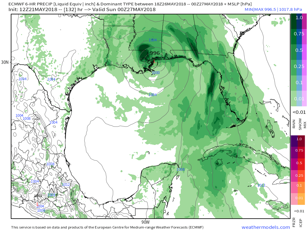
CMC would be a decent tornado producer along with the rain.
accu35
Member
- Joined
- Jan 5, 2017
- Messages
- 8,278
- Reaction score
- 9,645
Forecast to drop end of weekCurrent wind shear is a ----- . Good luck to this system , gonna be a struggle
Sent from my SM-J327VPP using Tapatalk

Brent
Member
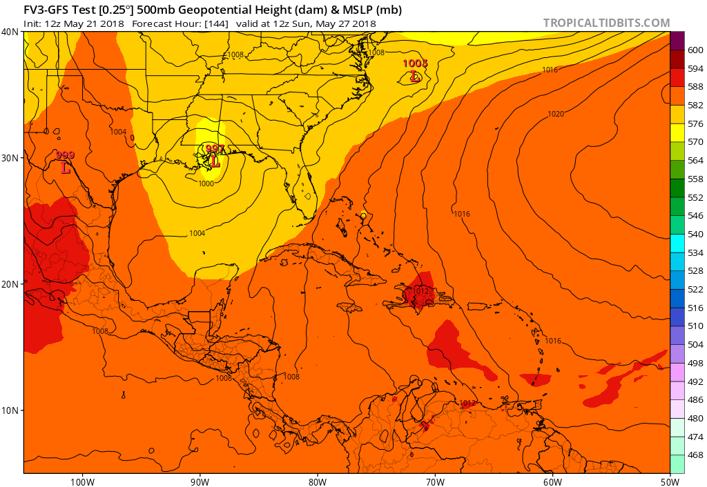
Euro definitely went east
accu35
Member
- Joined
- Jan 5, 2017
- Messages
- 8,278
- Reaction score
- 9,645
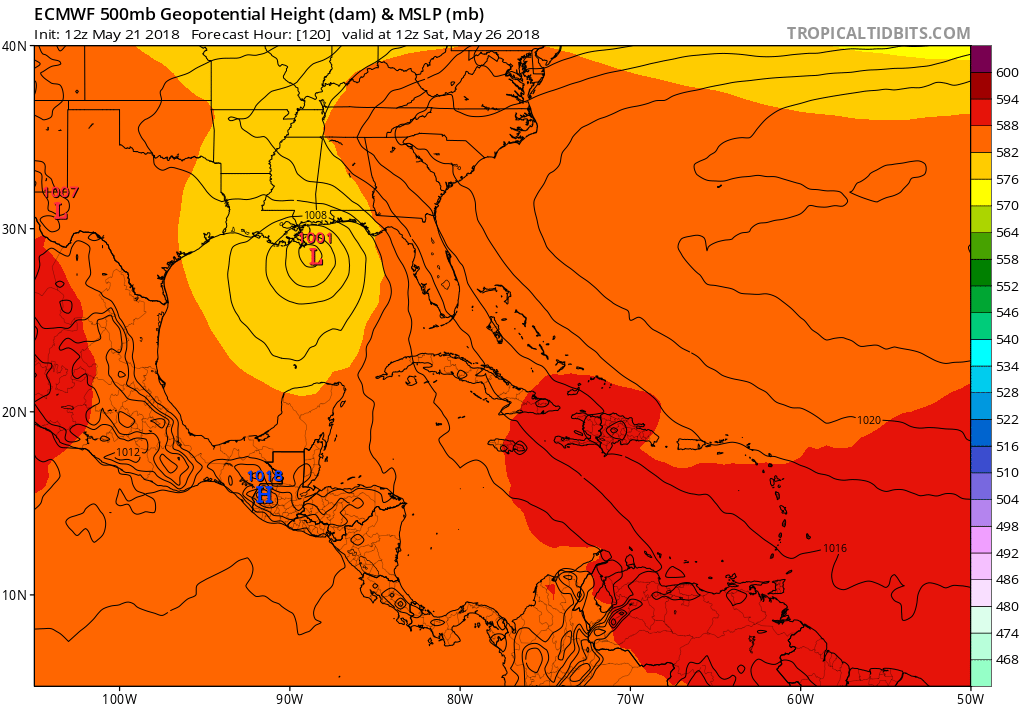
GFS shifts west and EURO east. I say from LA/Fl best bet. CMC/EURO is on agreementEuro definitely went east

Euro is much more progressive vs previous runs which is good
Sent from my SM-J327VPP using Tapatalk
Sent from my SM-J327VPP using Tapatalk