• Hello, please take a minute to check out our awesome content, contributed by the wonderful members of our community. We hope you'll add your own thoughts and opinions by making a free account!

Tropical Major Hurricane Florence

I would think that the mean of these ensembles would be a pretty good guess at this point. But who knows????

It's tightly clustered through 60 and good agreement from UK/GFS/Euro and hurricane models that at hour 60 Florence will be right off ILM/Morehead. Stalls in that vicinity for 36 hours. Then does it drift SSW like Euro or more WSW like GFS/UK.

models60.gif
 
They all agree now, like they kinda all agreed it would make landfall at the NC/SC border give or take. That changed, now there's a stall and a W/SW drift inland. My question is what's the next change going to be, and to where? To me there is no trend to hold on to because the consensus keeps changing. Still very interested to see HPC new track at 5 pm though. How can it not stall and make the captain hook inland when everything else does at this point? And it'll be kinda fun getting the tv mets to explain that to the general public...

I bet NHC slides 8am Friday spot a little south towards ILM and then shows a drift towards PGV/CAE.
 
They all agree now, like they kinda all agreed it would make landfall at the NC/SC border give or take. That changed, now there's a stall and a W/SW drift inland. My question is what's the next change going to be, and to where? To me there is no trend to hold on to because the consensus keeps changing. Still very interested to see HPC new track at 5 pm though. How can it not stall and make the captain hook inland when everything else does at this point? And it'll be kinda fun getting the tv mets to explain that to the general public...

This sentence times 100.

Only real consensus is Flo will head towards NC, somewhere between Wilmington and Morehead City. When she gets to the coast it's really up in the air right now where she will go.
 
NAM 18z is SW of 12z run and as approaches SC/NC shore already appears to be wobbling westward
 
The 18z NAM at 48 is 4mb stronger and a bit SW of the 12z at 54.
 
18z NAM at 54 is 2mb stronger and still a bit SW of the 12z at 60. It is moving due west toward ILM.

Edit: Make that due WNW or WWNW.
 
I almost want to see the NAM halt and do the Loop just to see the NHS and overall everyone head stratching
 
At 60, the 18z NAM is a good bit SW and 1mb stronger than 12z at 66. It's moving due west now toward ILMish. Probably going to stall in the next few frames, if it follows the trends.
 
Winds up to 140 mph, pressure down to 945 mb.

...DANGEROUS FLORENCE EXPECTED TO BRING LIFE-THREATENING STORM
SURGE AND RAINFALL TO PORTIONS OF THE CAROLINAS AND MID-ATLANTIC...


SUMMARY OF 500 PM AST...2100 UTC...INFORMATION
----------------------------------------------
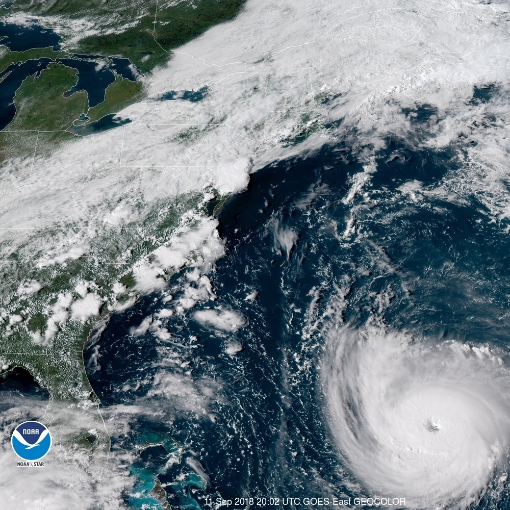
LOCATION...27.5N 67.1W
ABOUT 360 MI...580 KM SSW OF BERMUDA
ABOUT 785 MI...1260 KM ESE OF CAPE FEAR NORTH CAROLINA
MAXIMUM SUSTAINED WINDS...140 MPH...220 KM/H
PRESENT MOVEMENT...WNW OR 300 DEGREES AT 17 MPH...28 KM/H
MINIMUM CENTRAL PRESSURE...945 MB...27.91 INCHES

Also Hurricane and Storm Surge Warnings now in effect...

WATCHES AND WARNINGS
--------------------
CHANGES WITH THIS ADVISORY:

A Storm Surge Warning has been issued from South Santee
River, South Carolina, to Duck, North Carolina, and the Albemarle
and Pamlico Sounds, including the Neuse and Pamlico Rivers.

A Hurricane Warning has been issued from South Santee
River, South Carolina, to Duck, North Carolina, and the Albemarle
and Pamlico Sounds.

A Tropical Storm Watch has been issued from north of the North
Carolina/Virginia border to Cape Charles Light, Virginia, and for
the Chesapeake Bay south of New Point Comfort.
 
18z NAM at 69 still SW of 12z at 75. Pressure is the same. Malak wins. At hour 67, it hits the wall and begins jogging NE without making landfall.
 
152311_5day_cone_no_line_and_wind.png
 
Bouncing around off the coast at the end of the run. Yay.
 
Ok yes, the GFS showed the loop scenario first but it was well east of Cape Hatteras, so the mean track error is still likely to be an order of magnitude or more larger than the Euro before the loop, yawn.
 
3424445a27685d45e06d0cdd94a8372d8dbf3337dc987b6cb47f92370a8c8d6e.jpg
The ridging seems pretty strong pushing Flo more westward. Wouldn't be suprise if the direction gets pushed further southwest
 
Back
Top