-
Hello, please take a minute to check out our awesome content, contributed by the wonderful members of our community. We hope you'll add your own thoughts and opinions by making a free account!
You are using an out of date browser. It may not display this or other websites correctly.
You should upgrade or use an alternative browser.
You should upgrade or use an alternative browser.
Pattern Jarring January
- Thread starter ForsythSnow
- Start date


ForsythSnow
Moderator
Yep, the energy looks better, and there seems to be plenty of moisture.
NorthGaWinter4
Member
This kinda looks like the early December storm imo
That's a big improvement. Euro trend
Sent from my SM-J320VPP using Tapatalk
Sent from my SM-J320VPP using Tapatalk
packfan98
Moderator
GFS goes BOOM!

B
Brick Tamland
Guest
Only 5 days out, too. I really like the chances more when we see systems like this that develop slowly on the models instead of when they show a big storm 7 to 10 days out.
ForsythSnow
Moderator
Okay, I admit defeat. I better stop screaming dry air or that snow hole is going to verify. LOL. I think this could be a good storm, and maybe the one to fill in the holes that haven't had any yet.GFS goes BOOM!
GeorgiaGirl
Member
Heck, I was wrong. Looks great for NC.
SCweather
Member
This is what makes these sort of patterns fun. You got nothing but dry and cold air with nothing showing then all of a sudden the models throw a storm in there. This will be fun to watch. Hr 120 is looking good for my particular area.
RollTide18
Member
GFS goes BOOM!
Well I'll be...

packfan98
Moderator
POW!

B
Brick Tamland
Guest
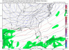
Wow, that's a nice large chunk with 3 to 6 inches for NC. No real sharp cutoff showing up.POW!
whatalife
Moderator
Very nice improvement/trend on the GFS. Looks like moisture for this system will not be a problem but again with this type of system it will be boom or bust.
Sent from my iPhone using Tapatalk
Sent from my iPhone using Tapatalk

B
Brick Tamland
Guest
Last runs of the Euro and GFS very similar with totals, too.
packfan98
Moderator
I love it when the Kuchera ratio gives more than 10:1. BAM!

Webberweather53
Meteorologist
The EPS is an utter joke after day 5-6 right now, checking the trend in 0z runs even against yesterday, the trough in the medium range which is associated w/ this threat for wintry weather has continued to strengthen as verification nears and is far cry from a massive ridge it was showing only 3 days ago for the same time frame. Give this another 2 days or so because the solutions even out to day 5 aren't particularly stable... Another ridge is showing up on the EPS at day 10, it probably won't verify either given there's a big ACWB event fixing to transpire over the Bering Sea & GOA coupled w/ a trough near Hawaii and north Atlantic blocking, all of which don't favor ridging along the eastern seaboard... At the very least if there is going to be a ridge here it will be transient at best
