Wintry January 14-16th storm potential.
- Thread starter TheBatman
- Start date
-
Hello, please take a minute to check out our awesome content, contributed by the wonderful members of our community. We hope you'll add your own thoughts and opinions by making a free account!
You are using an out of date browser. It may not display this or other websites correctly.
You should upgrade or use an alternative browser.
You should upgrade or use an alternative browser.


The 00z/06z EPS and 06z GEFS still show the three scenarios we've seen in various modeling over the past 24 hours: 1) mostly dry east of the apps with only a front end band west of the apps, 2) a warmer scenario with a coastal forming but cold press not enough except in the western Piedmont / Mountains east of the apps, and 3) there are still a handful of members on both ensembles that show the late blooming, explosive cyclogenesis solution that would favor the eastern Piedmont / Coastal Plain as cold gets wrapped into the system.
IMO, there's still time for it to go in any direction, but I definitely favor either 2 or 3.
Nice summary. I’m solidly in the Option #2 camp for a forecast as of now. Main area of accumulating snow in foothills and mountains
Yeah to get this east, we need to press the cold boundary more early then go sharp with the wave late
No surprise we ended up in Option #2. I figured Option 1 was a long shot. Good call @griteater, a good forecast shouldn't go unnoticed even if it's not the one we want.
Most of the local forecasts at the time of the discussion above were calling for dry in Raleigh or only a few sprinkles. Even as it rains out my window my pops for today are at 50%. Some things never change!


Precip shut off before we dropped below freezing. So close. 31.8 now.Freezing line is from Whitesburg to Douglasville, moving east.
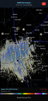
heavy flurries coming down here east of B'ham but radar shows nothing.
Arctic boundary squeezing out all the moisture out of the air. Had some flurries earlier here in Sylacauga but noting was showing on radar.
It actually does show some flurries around Birminghamheavy flurries coming down here east of B'ham but radar shows nothing.
Attachments
Light glazing briefly this morning, just enough to coat the deck. Like others have mentioned, light snow flurries blowing around now.
Last edited:
Very tiny snowflakes falling right now at the tail end, looks like ice needles almost though when they hit the surface.
Radar is showing a good snow in Shelby county and parts of Jefferson

Had to stick my head outside to see them but there are indeed teeny tiny little snow grains in the air. Temp is down to 24.
Same here as wellTiny flurries by Truist park. #winning
Reports of snow flurries in Loganville GA this morning. Glad to see my old stomping ground seeing something.
Precip shut off before we dropped below freezing. So close. It's very heavy overcast outside and 30 degrees.
I got down to 17.0 this morning. The grass is coated in an icy glaze. My car is iced over too. I could barely open the outer screen door. I was supposed to get down to 19 per the NWS forecast. I guess the ice accumulations helped the area to overachieve on low temps. Today's high is supposedly 34. We shall see if the freezing mark can be crossed this afternoon.
Temp is down to 24 now. It won't stop dropping and if we keep this cloud cover through the day I can't imagine what it'll be tonight after the sky clears and the wind keeps up some over the snowpack to the NW in TN. Not sure if 14 is too high or not yet.
Blue skies back home so it should clear out. However, the temp is holding at 21.Temp is down to 24 now. It won't stop dropping and if we keep this cloud cover through the day I can't imagine what it'll be tonight after the sky clears and the wind keeps up some over the snowpack to the NW in TN. Not sure if 14 is too high or not yet.
was a flaming 36 this amPrecip shut off before we dropped below freezing. So close. 31.8 now.
rain gone its 30 ?
Down to 27 here. I expect we will rise above freezing briefly this afternoon once the clouds move out. Already see signs of the overcast breaking up. Low of 18 seems reasonable for my area.