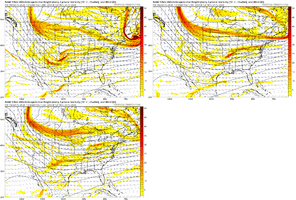
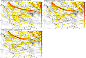
That’s always the risk. Of course next weekend it looks like we might want a bit of help from that ridge.I’m nervous about the ATR doing what it normally does last minute
-
Hello, please take a minute to check out our awesome content, contributed by the wonderful members of our community. We hope you'll add your own thoughts and opinions by making a free account!
You are using an out of date browser. It may not display this or other websites correctly.
You should upgrade or use an alternative browser.
You should upgrade or use an alternative browser.
Wintry January 14-16th storm potential.
- Thread starter TheBatman
- Start date
I'd generally agree with that. It seems like no matter the model changes, the north central piedmont seems to be a good locationIf I lived north of a line from Texarkana ->oxford->florence->Chattanooga->Kingsport I'd be feeling good this morning. Along and north from shreveport->starkville->Birmingham->alpharetta->gsp->Clt->gso I'm feeling decent but hoping for the agreement and the minor changes. from Jackson->mgm->Augusta-cae->Fayetteville->rocky mount we need help
Last edited:
OK. Other than the obvious that this is a look from the end of the NAM run, does this look not scream another round of overrunning past the initial SE 'storm'?


Oh it's screams more than that. If the rest of the 12z suite is there at 84 hours good luck everyoneOK. Other than the obvious that this is a look from the end of the NAM run, does this look not scream another round of overrunning past the initial SE 'storm'?

Biggest issue with that map is it came from the 84hr NAM.Oh it's screams more than that. If the rest of the 12z suite is there at 84 hours good luck everyone
Parker
Member
NAM is a Tennessee special
View attachment 141681
The NAM was still a good 12-24 hours before precip could fill in to areas further to the south.
iGRXY
Member
This is trending stronger on the ICON
Here’s the thing about the NAM at this range… it sucks at temperatures and precip, but it’s often very good at placement of features.Biggest issue with that map is it came from the 84hr NAM.
Am I the only one that remembers just two days ago that the ICON put the SER on steroids and dumped everything out west
This is trending stronger on the ICON
I thought that was the UKIEAm I the only one that remembers just two days ago that the ICON put the SER on steroids and dumped everything out west
griteater
Member
Nice summary. I’m solidly in the Option #2 camp for a forecast as of now. Main area of accumulating snow in foothills and mountainsThe 00z/06z EPS and 06z GEFS still show the three scenarios we've seen in various modeling over the past 24 hours: 1) mostly dry east of the apps with only a front end band west of the apps, 2) a warmer scenario with a coastal forming but cold press not enough except in the western Piedmont / Mountains east of the apps, and 3) there are still a handful of members on both ensembles that show the late blooming, explosive cyclogenesis solution that would favor the eastern Piedmont / Coastal Plain as cold gets wrapped into the system.
IMO, there's still time for it to go in any direction, but I definitely favor either 2 or 3.
Yeah to get this east, we need to press the cold boundary more early then go sharp with the wave late
It was bothI thought that was the UKIE
UKMET had a decent ice storm last night with this one.
Just minor differences lol.


Chattownsnow
Member
I really want to agree with you on that, but I just can't fully. I think inside of 60 the NAM begins to stabilize with the synoptic scale features, but it's pretty erratic otherwise (and I'm not just talking about this event). But you can see it's really bouncing around the last 3 runs at h5. (I know this is 12z NAM and 6z GFS, but just showing how the 72 hour forecast of each has changed over the past 3 runs).Here’s the thing about the NAM at this range… it sucks at temperatures and precip, but it’s often very good at placement of features.

Compare the last 3 runs of the NAM to the GFS, and you can see how erratic it has been.

Yeah I certainly wouldn’t trust it when it’s shuffled around like that. I do remember that in the 2nd storm of January 2022, the long range NAM was the first to identify that storm was going to be a bigger deal for the NC Piedmont in its H5 chartsI really want to agree with you on that, but I just can't fully. I think inside of 60 the NAM begins to stabilize with the synoptic scale features, but it's pretty erratic otherwise (and I'm not just talking about this event). But you can see it's really bouncing around the last 3 runs at h5. (I know this is 12z NAM and 6z GFS, but just showing how the 72 hour forecast of each has changed over the past 3 runs).
View attachment 141685
Compare the last 3 runs of the NAM to the GFS, and you can see how erratic it has been.
View attachment 141688
RoddyPiper
Member
Nothing much going east of there if that solution is correct with the placement of features.View attachment 141686RDPS basically nukes all of Tennessee. Run ends before things moved east of there though
JLL1973
Member
gfs is probably going to be a nice hit for the midsouth area
Cary_Snow95
Member
Think I’m throwing in the towel in Central NC. We’ve seen a lot of good trends but i think it’s asking too much at this lead. I’d expect cold air to be a problem this far east. Seems like a mountains and foothills storm imo.

