ForsythSnow
Moderator
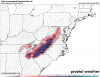
Per the NAM, there isn't any CAPE, no updraft helicity, and no sign of severe WX. The line only lasts a couple hours outside the temp change and quickly falls apart as well. It may look severe to you, but I see nothing outside a strong wind gust.The 3km NAM wants to develop an embedded squall line along the edge of the very sharp CAD boundary late on Sunday. Can't entirely rule out a threat for severe weather in this case especially those along and just east of the boundary. There will be an area of significantly enhanced storm relative helicity and baroclinicity wherever the SE edge of the CAD dome sets up
View attachment 3739