-
Hello, please take a minute to check out our awesome content, contributed by the wonderful members of our community. We hope you'll add your own thoughts and opinions by making a free account!
You are using an out of date browser. It may not display this or other websites correctly.
You should upgrade or use an alternative browser.
You should upgrade or use an alternative browser.
Wintry 2/3-2/4 Mixed Bag NC, SC, NE GA
- Thread starter Blue_Ridge_Escarpment
- Start date
ForsythSnow
Moderator
You know that's the 12KM NAM and we are in a very short range, so use the 3 KM. It's better. Here is where the run expects sleet and ZR. Mind I said sleet too. Second image shows why.View attachment 3758 12k NAM /latest run! Hug the NAM! Yes i know, there's not snow! Boom! Coutesy AmWX!


gawxnative
Member
You know that's the 12KM NAM and we are in a very short range, so use the 3 KM. It's better. Here is where the run expects sleet and ZR. Mind I said sleet too. Second image shows why.
View attachment 3759 View attachment 3759 View attachment 3759
gawxnative
Member
Well at least you made it into the SWS that FFC just issued...You know that's the 12KM NAM and we are in a very short range, so use the 3 KM. It's better. Here is where the run expects sleet and ZR. Mind I said sleet too. Second image shows why.
View attachment 3759 View attachment 3759 View attachment 3759
That looks even better for MBY!! There's a lot of high lollipops in NEGA!You know that's the 12KM NAM and we are in a very short range, so use the 3 KM. It's better. Here is where the run expects sleet and ZR. Mind I said sleet too. Second image shows why.
View attachment 3759 View attachment 3759 View attachment 3759
The NAM shows wintry precip near Chattanooga yet there's not even a SWS out for that area.
ForsythSnow
Moderator
Yep, and they now have Forsyth getting a lot more time than expected. Have to see the specifics tonight to see if the models are going to underplay the CAD or get it right.Well at least you made it into the SWS that FFC just issued...
packfan98
Moderator
Here's the best candidates for ice accrual. Take a look at where this map has below freezing temps.


Looks like Georgia is out of the game.Here's the best candidates for ice accrual. Take a look at where this map has below freezing temps.

Kylo
Member
Yeah, latest run only gives me .85 of accumulated ice!!! Glad it's on an island!
Kylo
Member
No one wants that! I need my trees! Verbatim it's prob not right. But it just confirms the colder stouter wedge trend shown on the NAMYeah, latest run only gives me .85 of accumulated ice!!! Glad it's on an island!

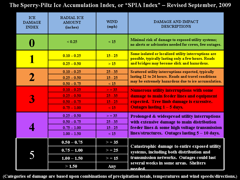
Figured I'd post this as a reminder.
Read the GSP discussion, mentioned it could get windy at some point tomorrow! RGEM has my back yard in the 2-3 category
ForsythSnow
Moderator
HRRR may be looking colder each run, and also seems to keep temps 33-36 and rain here. Seems very close, and if we keep the winds out of the NE like it shows, there are going to be issues, especially if the low goes south and pulls even more cold air down.
With temps forecast to be above freezing pretty much everywhere by noon tomorrow I would think this will be a low impact event ?
ForsythSnow
Moderator
Not according to the other runs. You can't go by that one map posted ealier, but all of the SR models and their trends. If they go the Here's what and trend colder, low impact is going to turn into ice storm. It all comes down to wind direction, low temps, temps when they wetbulb, low track, and start time.With temps forecast to be above freezing pretty much everywhere by noon tomorrow I would think this will be a low impact event ?
Aren't you forecast to be 45+ tomorrow afternoon ?Not according to the other runs. You can't go by that one map posted ealier, but all of the SR models and their trends. If they go the Here's what and trend colder, low impact is going to turn into ice storm. It all comes down to wind direction, low temps, temps when they wetbulb, low track, and start time.
ForsythSnow
Moderator
I looked at the models and it's at the end of the day, like evening when the rain stops.Aren't you forecast to be 45+ tomorrow afternoon ?


